Karpathos
From CruisersWiki
Summercruise (Talk | contribs) (→Diafani) |
Summercruise (Talk | contribs) (→Diafani) |
||
| Line 64: | Line 64: | ||
====Diafani==== | ====Diafani==== | ||
| - | GPS: {{Coord|35|45|N|27|12|E|}} | + | GPS: {{Coord|35|45|N|27|12|E|}} |
| - | + | {| class="infobox " style="width: 50em; text-align: right font-size: 90%;" | |
| - | + | ||
| - | + | ||
| - | + | ||
| - | {| class="infobox | + | |
|- | |- | ||
| - | | | + | | style="text-align:left;" |The new port was built and completed in 1995 on the NE coast of Karpathos now permits large Ferry Boats from Rhodes and Piraeus to dock in Diafani. Anchor stern to. Very helpful Greek will assist you, and drive you to Olympos, also has a great restaurant, not to be missed. ... more anon - |
| - | + | |<googlemap lat="35.755324" lon="27.212985" zoom="16" width="250" height="250" selector="no" controls="small">} | |
| + | --~~~~ | ||
===Anchorages=== | ===Anchorages=== | ||
Revision as of 15:50, 10 July 2009
Contents |
Kárpathos
| | Coords: {35°30.7′N, 27°12.8′E Chartlet: Chartlet Gallery: Photos |
Background
Kárpathos (Κάρπαθος), the Venetian Scarpanto, is one of the largest Dodecanese islands. Its highest mountain is Mt. Kalilimni at 1,188 m (3,900 ft). The island, with an area of 324.800 km2, is divided by this mountain in to two almost separate parts the South with most of the fertile land and inhabitants and the much wilder and isolated North. It is in the North and especially in the village of Olympos that, because of the isolation and now for, I suspect, tourist reasons, some of the folkloric customs and costumes are preserved.
Because Karpathos is isolated, it has very few anchorages, and the surrounding Karpathian Sea is notorious for its bad weather, Karpathos is very seldom visited by yachts. However, precisely for these reasons, Karpathos is one of the least spoiled islands in the Aegean and worthy of exploration.
In ancient times the island was named Porfiris, after the red dye extracted from a sea cell on the island. This dye was exported and up to the Byzantine times was used to color the garments of kings and emperors. Another ancient name for the island was Tetrapolis originating from its four cities: Vrykous, Possidion, Arkesia, and Nissyros. By the time of Homer it was called by its present name: Karpathos. It is believed that the name originates from Arpaktos or "robbery" because Karpathos was always an island of pirates. A few Mycenian artifacts have been excavated near of Pigadia.
By the middle ages pirates dominated the island and the city of Arkassa was a major slave market. In 1206 the island fell under the Frankish crusaders, to be followed by the Venetians. During the Ottoman times the Turks stayed away from this lawless island. It is said that many sunken pirate treasure lie in the bays of Vrontis and Arkassa.
In the early part of the 20th century, Karpathos, like the rest of the Dodecanese was under Italian occupation. During the World War II about 6,000 Italian troops were based on the island. After the war, Karpathos became part of Greece.
Because of the isolation of the island and poor conditions many of its inhabitants migrated to the US, and later to Australia. A sizable number of these immigrants have now returned and have brought back a sizable wealth. Karpathos today has one of of the highest university graduate population rate in Europe.
Karpathos also, has a very strong musical tradition. Like Crete the 15-syllable improvised mantinades (couplets) are very popular especially in the more isolated norther villages. Two Austrians, Rudolph Maria Brandl and Diether Reinsch after a ten year study and recordings published in 1992 a many volume work on the subject titled: Die Volksmusik der Insel Karpathos.
Charts
- BA 2824 Scarpanto (Karpathos) and Kasos islands
- Imray-Tetra G35 Dodecanese and the Coast of Turkey
- NIMA 54400 Nisos Samos to Nisos Rhodhos
- NIMA 2824 Scarpanto (Karpathos) and Kasos islands
- Greek 452 Rhodos to Castelorizo
Radio Nets
Also see Cruiser's Nets
- Greek Coast Guard - VHF channel 12, Tel. +30 2450 22 227
- Olympia Radio - VHF channel 03
Approaches to Karpathos are straightforward but there are very strong gusts during the meltemi season.
Ports and Popular Stops
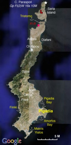
Karpathos has only one harbor, of questionable safety, and considering the size of the island only a few anchorages.
Pigadia
| GPS: 35°30.7′N, 27°12.8′E
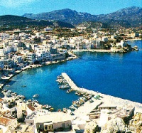
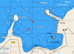
Pigadia(Πυγάδια) or Port Karpathos is the only harbor in the island of Karpathos. It is exposed to the NE and with either the or south winds develops serious swell. If there is room, and if your draft allows, moor stern-to in the inner fishing harbor. Otherwise, moor stern-to with long scope. Leave boat unattended only in settled weather. Warning: The harbor is subject to very strong gusts and it can be uncomfortable and even dangerous with the meltemi. It is better to anchor in Pigadia Bay, just 2 nM north of the harbor. |
Diafani
GPS: 35°45′N, 27°12′E
| The new port was built and completed in 1995 on the NE coast of Karpathos now permits large Ferry Boats from Rhodes and Piraeus to dock in Diafani. Anchor stern to. Very helpful Greek will assist you, and drive you to Olympos, also has a great restaurant, not to be missed. ... more anon - |


