Korinthiakos Kolpos
From CruisersWiki
Istioploos (Talk | contribs) (Added Chartlets) |
Istioploos (Talk | contribs) (Rearranged and added some new material) |
||
| Line 6: | Line 6: | ||
===Charts=== | ===Charts=== | ||
| - | BA 1600 Korinthiakós Kólpos | + | ; BA |
| - | + | : 1600 Korinthiakós Kólpos | |
| - | Imray-Tetra G13 Gulfs of Patras and Corinth | + | ; Imray-Tetra |
| - | + | : G13 Gulfs of Patras and Corinth | |
| - | NIMA 54289 Korinthiakos Kolpos | + | ; NIMA |
| - | + | : 54289 Korinthiakos Kolpos | |
| - | Greek | + | ; Greek |
| + | : 232 Korinthiakos Kolpos | ||
===Radio Nets=== | ===Radio Nets=== | ||
| Line 19: | Line 20: | ||
* Olympia Radio - VHF channels 02, 64, & 85 | * Olympia Radio - VHF channels 02, 64, & 85 | ||
| - | === | + | ===Weather=== |
The prevailing wind in Korinthiakos Kolpos in the summer is from the west and it rarely exceeds force 6. Like the ''meltemi'' it reaches it peak in the middle of the day and subsides in the evening. In the autumn and spring the wind can be either from the east or from the west. | The prevailing wind in Korinthiakos Kolpos in the summer is from the west and it rarely exceeds force 6. Like the ''meltemi'' it reaches it peak in the middle of the day and subsides in the evening. In the autumn and spring the wind can be either from the east or from the west. | ||
| - | <font color="red">Danger:</font> From the late autumn to the early spring the weather can be very volatile with violent thunderstorms. I have experienced very severe weather, force 9, while approaching [[#Corinth|Corinth]]. --[[User:Istioploos|Istioploos]] | + | <font color="red">Danger:</font> From the late autumn to the early spring the weather can be very volatile with violent thunderstorms. I have experienced very severe weather, force 9, while approaching [[#Corinth|Corinth]]. --[[User:Istioploos|Istioploos]] |
| + | |||
| + | ===Approach and Navigation=== | ||
| + | Sailing from west to east you enter the gulf from the [[Patraikos_Kolpos|Gulf of Patras]] via the [[Patraikos_Kolpos#Rio-Antirio Bridge|Rio-Antirio Strait]]. To reach the Aegean, you exit the Gulf of Corinth via the [[Corinth Canal]]. | ||
| - | = | + | <font color="red">Warning:</font> There is no problem passing under the bridge, but be aware that the west going traffic keeps to the left rather than to the right. Follow the Green [http://www.cgate.co.il/eng/Seamanship/iala_a.htm IALA A] symbol. |
| - | + | ||
===Ports and Popular Stops=== | ===Ports and Popular Stops=== | ||
====Nafpaktos==== | ====Nafpaktos==== | ||
{| | {| | ||
| - | |valign="top"| | + | |valign="top"|[[image:World_icon.png]] {{Coord|38|23.51|N|21|49.75|E|}}<br/> |
[http://en.wikipedia.org/wiki/Nafpaktos Nafpaktos] or Navpaktos (Ναύπακτος) or Lepanto is a jewel of a tiny mediaeval harbor well protected from from the the prevailing winds although SW and SE winds can cause some uncomfortable swell. The waterfront of the town is delightful. Unfortunately there are two problems that make this idyllic harbor less so: It is small and it is hard to find room (arrive early), and it is very noisy. The nose comes from the heavy truck traffic and from the music at night. I mean real objectionable blearing music form a night club at the E entrance, just a few meters away from your yacht. | [http://en.wikipedia.org/wiki/Nafpaktos Nafpaktos] or Navpaktos (Ναύπακτος) or Lepanto is a jewel of a tiny mediaeval harbor well protected from from the the prevailing winds although SW and SE winds can cause some uncomfortable swell. The waterfront of the town is delightful. Unfortunately there are two problems that make this idyllic harbor less so: It is small and it is hard to find room (arrive early), and it is very noisy. The nose comes from the heavy truck traffic and from the music at night. I mean real objectionable blearing music form a night club at the E entrance, just a few meters away from your yacht. | ||
| Line 40: | Line 43: | ||
=====Last Visited & Details Checked (and updated here)===== | =====Last Visited & Details Checked (and updated here)===== | ||
''Date of member's visit to this Port/Stop & this page's details validated'': | ''Date of member's visit to this Port/Stop & this page's details validated'': | ||
| - | * June 1995 --[[User:Istioploos|Istioploos]] | + | * June 1995 --[[User:Istioploos|Istioploos]] [[Image:Greece_Icon.png]] |
* | * | ||
| Line 48: | Line 51: | ||
====Galaxidhi==== | ====Galaxidhi==== | ||
{| | {| | ||
| - | |valign="top"| | + | |valign="top"|[[image:World_icon.png]] {{Coord|38|22.65|N|22|23.34|E|}} |
[http://en.wikipedia.org/wiki/Galaxidi Galaxidhi] (Γαλαξίδι) is harbor in the mainland. The town has had a long history with shipping and shipbuilding. Today it is an upscale picturesque town popular with Athenians. It is good place to leave your boat for a visit to [[#Delphi|Delphi]]. | [http://en.wikipedia.org/wiki/Galaxidi Galaxidhi] (Γαλαξίδι) is harbor in the mainland. The town has had a long history with shipping and shipbuilding. Today it is an upscale picturesque town popular with Athenians. It is good place to leave your boat for a visit to [[#Delphi|Delphi]]. | ||
| Line 62: | Line 65: | ||
=====Last Visited & Details Checked (and updated here)===== | =====Last Visited & Details Checked (and updated here)===== | ||
''Date of member's visit to this Port/Stop & this page's details validated'': | ''Date of member's visit to this Port/Stop & this page's details validated'': | ||
| - | * July 1995 --[[User:Istioploos|Istioploos]] | + | * July 1995 --[[User:Istioploos|Istioploos]] [[Image:Greece_Icon.png]] |
* | * | ||
| Line 68: | Line 71: | ||
|} | |} | ||
====Itea==== | ====Itea==== | ||
| - | + | [[image:World_icon.png]] {{Coord|38|25.74|N|22|25.37|E|}} - [http://mapserver.mytopo.com/homepage/index.cfm?lat=38.429&lon=22.422833&scale=24000&zoom=50&type=1 Chartlet], [http://www.panoramio.com/map/#lt=38.429&ln=22.422833&z=0&k=0&a=1&tab=2 Photos]<br/> | |
[http://en.wikipedia.org/wiki/Itea%2C_Greece Itea] (Ιτέα) is a small commercial harbor, used mostly for agricultural products. | [http://en.wikipedia.org/wiki/Itea%2C_Greece Itea] (Ιτέα) is a small commercial harbor, used mostly for agricultural products. | ||
| Line 77: | Line 80: | ||
====Corinth==== | ====Corinth==== | ||
{| | {| | ||
| - | |valign="top"| | + | |valign="top"|[[image:World_icon.png]] {{Coord|37|56.47|N|22|56.28|E|}} |
[http://en.wikipedia.org/wiki/Corinth Corinth] or Kórinthos (Κόρινθος) is a large city on the SE of the Gulf of Corinth. It is a good place to leave the yacht while visiting the many interesting archeological sites within a few hours drive. | [http://en.wikipedia.org/wiki/Corinth Corinth] or Kórinthos (Κόρινθος) is a large city on the SE of the Gulf of Corinth. It is a good place to leave the yacht while visiting the many interesting archeological sites within a few hours drive. | ||
| Line 86: | Line 89: | ||
=====Last Visited & Details Checked (and updated here)===== | =====Last Visited & Details Checked (and updated here)===== | ||
''Date of member's visit to this Port/Stop & this page's details validated'': | ''Date of member's visit to this Port/Stop & this page's details validated'': | ||
| - | * September 2004 --[[User:Istioploos|Istioploos]] | + | * September 2004 --[[User:Istioploos|Istioploos]] [[Image:Greece_Icon.png]] |
* | * | ||
| + | |||
===Marinas & Yacht Clubs=== | ===Marinas & Yacht Clubs=== | ||
None. | None. | ||
| Line 97: | Line 101: | ||
====Anemokambi==== | ====Anemokambi==== | ||
{| | {| | ||
| - | |valign="top"| | + | |valign="top"|[[image:World_icon.png]] {{Coord|38|21.07|N|22|22.93|E|}} |
Anemokámbi (Ανεμοκάμπι) or Andromaki or Ayios Andreas is relative isolated, just some houses on the S side, almost landlocked cove on the mainland, a few miles W of [[#Galaxidhi|Galaxidhi]]. Unfortunately there is a fish farm nearby (N entrance). | Anemokámbi (Ανεμοκάμπι) or Andromaki or Ayios Andreas is relative isolated, just some houses on the S side, almost landlocked cove on the mainland, a few miles W of [[#Galaxidhi|Galaxidhi]]. Unfortunately there is a fish farm nearby (N entrance). | ||
| Line 104: | Line 108: | ||
=====Last Visited & Details Checked (and updated here)===== | =====Last Visited & Details Checked (and updated here)===== | ||
''Date of member's visit to this Port/Stop & this page's details validated'': | ''Date of member's visit to this Port/Stop & this page's details validated'': | ||
| - | * June 1995 --[[User:Istioploos|Istioploos]] | + | * June 1995 --[[User:Istioploos|Istioploos]] [[Image:Greece_Icon.png]] |
* | * | ||
====Ayioi Saranda==== | ====Ayioi Saranda==== | ||
| - | + | [[image:World_icon.png]] {{Coord|38|21.78|N|22|37.15|E|}} - [http://mapserver.mytopo.com/homepage/index.cfm?lat=38.363&lon=22.619167&scale=24000&zoom=50&type=1 Chartlet], [http://www.panoramio.com/map/#lt=38.363&ln=22.619167&z=0&k=0&a=1&tab=2 Photos]<br/> | |
Ayioi Saranda (Άγιοι Σαράντα - Forty Saints) or Saranti is is a small village the bay just few nM E of [[#Galaxidhi|Galaxidhi]]. It is well protected from the prevailing winds. You can either anchor off in 10-15 m or anchor and tie to the small quay. There is good fish restaurant here. A pleasant anchorage. | Ayioi Saranda (Άγιοι Σαράντα - Forty Saints) or Saranti is is a small village the bay just few nM E of [[#Galaxidhi|Galaxidhi]]. It is well protected from the prevailing winds. You can either anchor off in 10-15 m or anchor and tie to the small quay. There is good fish restaurant here. A pleasant anchorage. | ||
=====Last Visited & Details Checked (and updated here)===== | =====Last Visited & Details Checked (and updated here)===== | ||
''Date of member's visit to this Port/Stop & this page's details validated'': | ''Date of member's visit to this Port/Stop & this page's details validated'': | ||
| - | * 1986 --[[User:Istioploos|Istioploos]] | + | * 1986 --[[User:Istioploos|Istioploos]] [[Image:Greece_Icon.png]] |
* | * | ||
====Loutraki==== | ====Loutraki==== | ||
| - | + | [[image:World_icon.png]] {{Coord|37|58.49|N|22|57.87|E|}} - [http://mapserver.mytopo.com/homepage/index.cfm?lat=37.974833&lon=22.9645&scale=24000&zoom=50&type=1 Chartlet], [http://www.panoramio.com/map/#lt=37.976105&ln=22.965074&z=2&k=0&a=1&tab=2 Photos]<br/> | |
Loutráki (Λουτράκι) or Ormos Loutrakíou is an open bay N of [[#Corinth|Corinth]] and the Canal. It offers shelter from the NE wind but is open to the W and S. There large hotels and it can be noisy. Anchor in 3-6 m. The bottom is sand and weed with some rocks and the holding is not everywhere good. | Loutráki (Λουτράκι) or Ormos Loutrakíou is an open bay N of [[#Corinth|Corinth]] and the Canal. It offers shelter from the NE wind but is open to the W and S. There large hotels and it can be noisy. Anchor in 3-6 m. The bottom is sand and weed with some rocks and the holding is not everywhere good. | ||
=====Last Visited & Details Checked (and updated here)===== | =====Last Visited & Details Checked (and updated here)===== | ||
''Date of member's visit to this Port/Stop & this page's details validated'': | ''Date of member's visit to this Port/Stop & this page's details validated'': | ||
| - | * July 1995 --[[User:Istioploos|Istioploos]] | + | * July 1995 --[[User:Istioploos|Istioploos]] [[Image:Greece_Icon.png]] |
* | * | ||
| Line 129: | Line 133: | ||
====Trizonia==== | ====Trizonia==== | ||
[[Image:Greece_Trizonia_h.jpg|250px|thumb|right|Chart of Trizonia - [http://www.panoramio.com/map/#lt=38.369605&ln=22.076147&z=1&k=0&a=1&tab=2 Photos]<br/>''Click for larger view'']] | [[Image:Greece_Trizonia_h.jpg|250px|thumb|right|Chart of Trizonia - [http://www.panoramio.com/map/#lt=38.369605&ln=22.076147&z=1&k=0&a=1&tab=2 Photos]<br/>''Click for larger view'']] | ||
| - | + | [[image:World_icon.png]] {{Coord|38|22.08|N|22|04.66|E|}}<br/> | |
Trizónia (Τριζόνια) is small island on the NW side of the Corinthian Gulf. There is only a small hamlet on the island, yet there are 2-3 restaurants serving the local specialty: crayfish. Sometime in the early 90's construction began on a marina. It is not yet finished, and it is free. Moor side-to or anchor and back up on one of the moles. Alternatively you can always anchor off in 3-6 m depth. The bottom is mud and weed and provides good holding. The cove provides an excellent all around shelter. Many boats have wintered here. Despite the "marina" it is an attractive anchorage. | Trizónia (Τριζόνια) is small island on the NW side of the Corinthian Gulf. There is only a small hamlet on the island, yet there are 2-3 restaurants serving the local specialty: crayfish. Sometime in the early 90's construction began on a marina. It is not yet finished, and it is free. Moor side-to or anchor and back up on one of the moles. Alternatively you can always anchor off in 3-6 m depth. The bottom is mud and weed and provides good holding. The cove provides an excellent all around shelter. Many boats have wintered here. Despite the "marina" it is an attractive anchorage. | ||
=====Last Visited & Details Checked (and updated here)===== | =====Last Visited & Details Checked (and updated here)===== | ||
''Date of member's visit to this Port/Stop & this page's details validated'': | ''Date of member's visit to this Port/Stop & this page's details validated'': | ||
| - | * October 2004 --[[User:Istioploos|Istioploos]] | + | * October 2004 --[[User:Istioploos|Istioploos]] [[Image:Greece_Icon.png]] |
* | * | ||
====Alkonides==== | ====Alkonides==== | ||
| - | + | [[image:World_icon.png]] {{Coord|38|06.88|N|22|59.25|E|}} - [http://www.panoramio.com/map/#lt=38.114667&ln=22.987500&z=3&k=0&a=1&tab=2 Photos]<br/> | |
Alkonides (Αλκονίδες) is a very nice island on the SE of the Gulf of Corinth. It has lots of birds. Approach form the North. | Alkonides (Αλκονίδες) is a very nice island on the SE of the Gulf of Corinth. It has lots of birds. Approach form the North. | ||
| Line 145: | Line 149: | ||
=====Last Visited & Details Checked (and updated here)===== | =====Last Visited & Details Checked (and updated here)===== | ||
''Date of member's visit to this Port/Stop & this page's details validated'': | ''Date of member's visit to this Port/Stop & this page's details validated'': | ||
| - | * July 1995 --[[User:Istioploos|Istioploos]] | + | * July 1995 --[[User:Istioploos|Istioploos]] [[Image:Greece_Icon.png]] |
* | * | ||
===Routes/Passages To/From=== | ===Routes/Passages To/From=== | ||
| - | + | * [[Circumnavigating the Peloponnese]] | |
===Tourism & things to do ashore=== | ===Tourism & things to do ashore=== | ||
| + | {| class="wikitable" align=right | ||
| + | |- | ||
| + | |[[Image:Galaxidi_Boat.jpg|250px]]<br/><small>Boat Painting<br />Galxidi Nautical Museum<br/>''Click for larger view</small> | ||
| + | |- | ||
| + | |[[Image:Delphi1.jpg|250px]]<br/><small>Delphi<br/>''Click for larger view'</small> | ||
| + | |- | ||
| + | |[[Image:Delphi2.jpg|250px]]<br/><small>The Charioteer of Delphi<br/>''Click for larger view''</small> | ||
| + | |- | ||
| + | |[[Image:Mycenae1.jpg|250px]]<br/><small>The Gates of Mycenae<br/>''Click for larger view''</small> | ||
| + | |} | ||
====In Nafpaktos==== | ====In Nafpaktos==== | ||
Walk around the ramparts of the harbor. Also, if you have time walk up to the [http://www.greeka.com/sterea/nafpaktos/nafpaktos-architecture/nafpaktos-venetian-castle.htm castle] with its distinct bell-tower. | Walk around the ramparts of the harbor. Also, if you have time walk up to the [http://www.greeka.com/sterea/nafpaktos/nafpaktos-architecture/nafpaktos-venetian-castle.htm castle] with its distinct bell-tower. | ||
====In Galaxidi==== | ====In Galaxidi==== | ||
| - | + | Other than wandering in it lovely streets you should visit the [http://www.culture.gr/h/1/eh151.jsp?obj_id=3351 Nautical Museum] which houses a good collection of 19th century model ships (built in Galaxidhi), paintings, figureheads, and nautical instruments. Also worth visiting is the [http://odysseus.culture.gr/h/1/eh151.jsp?obj_id=3418 Archaeological Collection] which is housed within the Nautical Museum. | |
| - | + | ||
| - | + | ||
| - | + | ||
| - | + | ||
==== Delphi==== | ==== Delphi==== | ||
From [[#Galaxidhi|Galaxidhi]] you can take a taxi or a local bus to [http://en.wikipedia.org/wiki/Delphi Delphi], about 10 km. Delphi is one of the most significant archaeological sites in Greece. While in Delphi visit the [http://odysseus.culture.gr/h/1/eh151.jsp?obj_id=3404 Museum] which houses many masterpieces along with the breath taking [http://en.wikipedia.org/wiki/Charioteer_of_Delphi Charioteer]. | From [[#Galaxidhi|Galaxidhi]] you can take a taxi or a local bus to [http://en.wikipedia.org/wiki/Delphi Delphi], about 10 km. Delphi is one of the most significant archaeological sites in Greece. While in Delphi visit the [http://odysseus.culture.gr/h/1/eh151.jsp?obj_id=3404 Museum] which houses many masterpieces along with the breath taking [http://en.wikipedia.org/wiki/Charioteer_of_Delphi Charioteer]. | ||
| - | |||
| - | |||
| - | |||
| - | |||
====From Corinth==== | ====From Corinth==== | ||
| - | |||
From [[#Corinth|Corinth]] one can visit [http://en.wikipedia.org/wiki/Ancient_Corinth Ancient Corinth] (also the [http://www.ancientcorinth.net/museum.aspx Museum] there) and [http://en.wikipedia.org/wiki/Acrocorinth Acrocorinthos], as well as [http://humanities.uchicago.edu/orgs/isthmia/isthmia.html Isthmia] and the [http://odysseus.culture.gr/h/1/gh151.jsp?obj_id=3377 Isthmia Museum] (several of the exhibits there from [[West_Saronikos#Kechries|Kechries]] have been found by my wife Dr. Alice S. Riginos and even a few underwater finds by me --[[User:Istioploos|Istioploos]] 16:48, 9 May 2008 (MDT)). | From [[#Corinth|Corinth]] one can visit [http://en.wikipedia.org/wiki/Ancient_Corinth Ancient Corinth] (also the [http://www.ancientcorinth.net/museum.aspx Museum] there) and [http://en.wikipedia.org/wiki/Acrocorinth Acrocorinthos], as well as [http://humanities.uchicago.edu/orgs/isthmia/isthmia.html Isthmia] and the [http://odysseus.culture.gr/h/1/gh151.jsp?obj_id=3377 Isthmia Museum] (several of the exhibits there from [[West_Saronikos#Kechries|Kechries]] have been found by my wife Dr. Alice S. Riginos and even a few underwater finds by me --[[User:Istioploos|Istioploos]] 16:48, 9 May 2008 (MDT)). | ||
| Line 175: | Line 180: | ||
===Fuel, Water, & Electricity=== | ===Fuel, Water, & Electricity=== | ||
| - | + | ; Fuel | |
| - | + | ; In [[#Nafpaktos|Nafpaktos]] the local gas station on the W side of the harbor runs a long hose to the quay | |
| - | + | ; I was told that arrangements can be made in [[#Galaxidhi|Galaxidhi]] for a mini-tanker to deliver fuel, but have not used it--[[User:Istioploos|Istioploos]] | |
| - | + | : In [[#Corinth|Corinth]] a mini tank can be called | |
| - | + | ; Water | |
| - | + | : In [[#Nafpaktos|Nafpaktos]] there is an outlet is on the S mole | |
| - | + | : On the quay of [[#Galaxidhi|Galaxidhi]] | |
| - | + | : There is an outlet on the quay [[#Corinth|Corinth]] but it may be locked. Ask for the attendant | |
| - | + | : In the hamlet of [[#Trizonia|Trizonia]] | |
| - | + | ; Electricity | |
| - | + | : N/A (Not Available) | |
| - | + | ||
| - | N/A | + | |
===Laundry=== | ===Laundry=== | ||
| Line 193: | Line 196: | ||
* | * | ||
| - | ===Grocery Stores=== | + | ===Grocery & Supply Stores=== |
* There are several stores in [[#Nafpaktos|Nafpaktos]] | * There are several stores in [[#Nafpaktos|Nafpaktos]] | ||
* Good provision shopping in [[#Galaxidhi|Galaxidhi]] | * Good provision shopping in [[#Galaxidhi|Galaxidhi]] | ||
| Line 220: | Line 223: | ||
===References & Publications=== | ===References & Publications=== | ||
| - | See [[Greece#References_&_Publications|Greece]] | + | ''See [[Greece#References_&_Publications|Greece]]''. |
===Cruiser's Friends=== | ===Cruiser's Friends=== | ||
Revision as of 14:02, 19 January 2010
Korinthiakos Kolpos
Background
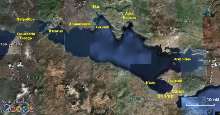
Korinthiakos Kolpos (Κορινθιακός Κόλπος) or Gulf of Corinth is dominated by the large commercial harbor of Corinth (Κόρινθος). It is bounded on the west by the Rio-Antirio strait leading to the Gulf of Patras, to the north by mainland Greece, to the east by the Corinth Canal leading to the Saronic Gulf, and to the south by northern Peloponnese. The gulf is not a favored cruising ground but it is passage route of yachts coming or going from the Ionian Sea to the Aegean. Nevertheless there are here several pleasant ports and anchorages.
Charts
- BA
- 1600 Korinthiakós Kólpos
- Imray-Tetra
- G13 Gulfs of Patras and Corinth
- NIMA
- 54289 Korinthiakos Kolpos
- Greek
- 232 Korinthiakos Kolpos
Radio Nets
Also see Cruiser's Nets
- Coast Guard - VHF channel 12, tel. +30 27410 28 888
- Olympia Radio - VHF channels 02, 64, & 85
Weather
The prevailing wind in Korinthiakos Kolpos in the summer is from the west and it rarely exceeds force 6. Like the meltemi it reaches it peak in the middle of the day and subsides in the evening. In the autumn and spring the wind can be either from the east or from the west.
Danger: From the late autumn to the early spring the weather can be very volatile with violent thunderstorms. I have experienced very severe weather, force 9, while approaching Corinth. --Istioploos
Sailing from west to east you enter the gulf from the Gulf of Patras via the Rio-Antirio Strait. To reach the Aegean, you exit the Gulf of Corinth via the Corinth Canal.
Warning: There is no problem passing under the bridge, but be aware that the west going traffic keeps to the left rather than to the right. Follow the Green IALA A symbol.
Ports and Popular Stops
Nafpaktos
Nafpaktos or Navpaktos (Ναύπακτος) or Lepanto is a jewel of a tiny mediaeval harbor well protected from from the the prevailing winds although SW and SE winds can cause some uncomfortable swell. The waterfront of the town is delightful. Unfortunately there are two problems that make this idyllic harbor less so: It is small and it is hard to find room (arrive early), and it is very noisy. The nose comes from the heavy truck traffic and from the music at night. I mean real objectionable blearing music form a night club at the E entrance, just a few meters away from your yacht. Anchor in about 3 m depth and back up to the SE mole. Warning: Be prepared to be squeezed by boats arriving after you. Last Visited & Details Checked (and updated here)Date of member's visit to this Port/Stop & this page's details validated:
|
Galaxidhi
Galaxidhi (Γαλαξίδι) is harbor in the mainland. The town has had a long history with shipping and shipbuilding. Today it is an upscale picturesque town popular with Athenians. It is good place to leave your boat for a visit to Delphi. The harbor offers a good all around shelter although there can be some swell with NE winds. Backup to the quay after anchoring in 3-4 m depth. The bottom is mud and weed and provides good holding. Danger: In the entrance to the harbor stay clear of the small island of Ayios Yioryios and its surrounding reefs. Use a good large scale chart.
Last Visited & Details Checked (and updated here)Date of member's visit to this Port/Stop & this page's details validated:
|
Itea
![]() 38°25.74′N, 22°25.37′E - Chartlet, Photos
38°25.74′N, 22°25.37′E - Chartlet, Photos
Itea (Ιτέα) is a small commercial harbor, used mostly for agricultural products.
Itea is a port of entry, however, since very few yachts call here, it may be better to clear into/out of Greece in more mainstream port where the bureaucratic procedures are more streamlined.
The harbor is safe and it is good alternative to Galaxidhi for leaving the boat for a visit to [[#Delphi|Delphi].
Corinth
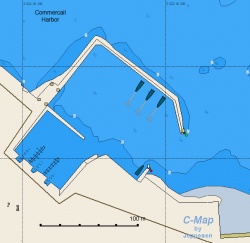
Corinth or Kórinthos (Κόρινθος) is a large city on the SE of the Gulf of Corinth. It is a good place to leave the yacht while visiting the many interesting archeological sites within a few hours drive. While Corinth is mainly a commercial harbor there is a small yacht harbor within the commercial port. It provides good all around shelter. There are floating docks which make it rather crowded. Either anchor in 3-4 m or take one of the layed moorings and back up to the dock. The bottom is mud and provides good holding. Danger: With strong NE winds entering and leaving the commercial harbor can be dangerous. Last Visited & Details Checked (and updated here)Date of member's visit to this Port/Stop & this page's details validated:
Marinas & Yacht ClubsNone. |
Anchorages
Anemokambi
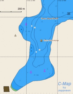
Anemokámbi (Ανεμοκάμπι) or Andromaki or Ayios Andreas is relative isolated, just some houses on the S side, almost landlocked cove on the mainland, a few miles W of Galaxidhi. Unfortunately there is a fish farm nearby (N entrance). Anchor in 3-10 m. The bottom is mud and weed, good holding. Last Visited & Details Checked (and updated here)Date of member's visit to this Port/Stop & this page's details validated:
Ayioi Saranda
Last Visited & Details Checked (and updated here)Date of member's visit to this Port/Stop & this page's details validated:
Loutraki
Last Visited & Details Checked (and updated here)Date of member's visit to this Port/Stop & this page's details validated:
|
Offshore Islands
Trizonia
![]() 38°22.08′N, 22°04.66′E
38°22.08′N, 22°04.66′E
Trizónia (Τριζόνια) is small island on the NW side of the Corinthian Gulf. There is only a small hamlet on the island, yet there are 2-3 restaurants serving the local specialty: crayfish. Sometime in the early 90's construction began on a marina. It is not yet finished, and it is free. Moor side-to or anchor and back up on one of the moles. Alternatively you can always anchor off in 3-6 m depth. The bottom is mud and weed and provides good holding. The cove provides an excellent all around shelter. Many boats have wintered here. Despite the "marina" it is an attractive anchorage.
Last Visited & Details Checked (and updated here)
Date of member's visit to this Port/Stop & this page's details validated:
- October 2004 --Istioploos

Alkonides
![]() 38°06.88′N, 22°59.25′E - Photos
38°06.88′N, 22°59.25′E - Photos
Alkonides (Αλκονίδες) is a very nice island on the SE of the Gulf of Corinth. It has lots of birds. Approach form the North.
Danger: There are large, just below the surface, boulders. Have a lookout at the bow while approaching.
Last Visited & Details Checked (and updated here)
Date of member's visit to this Port/Stop & this page's details validated:
- July 1995 --Istioploos

Routes/Passages To/From
Tourism & things to do ashore
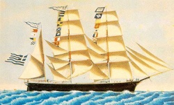 Boat Painting Galxidi Nautical Museum Click for larger view |
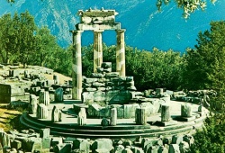 Delphi Click for larger view' |
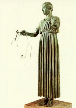 The Charioteer of Delphi Click for larger view |
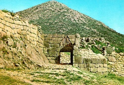 The Gates of Mycenae Click for larger view |
In Nafpaktos
Walk around the ramparts of the harbor. Also, if you have time walk up to the castle with its distinct bell-tower.
In Galaxidi
Other than wandering in it lovely streets you should visit the Nautical Museum which houses a good collection of 19th century model ships (built in Galaxidhi), paintings, figureheads, and nautical instruments. Also worth visiting is the Archaeological Collection which is housed within the Nautical Museum.
Delphi
From Galaxidhi you can take a taxi or a local bus to Delphi, about 10 km. Delphi is one of the most significant archaeological sites in Greece. While in Delphi visit the Museum which houses many masterpieces along with the breath taking Charioteer.
From Corinth
From Corinth one can visit Ancient Corinth (also the Museum there) and Acrocorinthos, as well as Isthmia and the Isthmia Museum (several of the exhibits there from Kechries have been found by my wife Dr. Alice S. Riginos and even a few underwater finds by me --Istioploos 16:48, 9 May 2008 (MDT)).
Further away from Corinth there the most important Bronze Age sites of Mycenae (the citadel, the tombs, the museum) and Tiryns.
Fuel, Water, & Electricity
- Fuel
- In Nafpaktos the local gas station on the W side of the harbor runs a long hose to the quay
- I was told that arrangements can be made in Galaxidhi for a mini-tanker to deliver fuel, but have not used it--Istioploos
- In Corinth a mini tank can be called
- Water
- In Nafpaktos there is an outlet is on the S mole
- On the quay of Galaxidhi
- There is an outlet on the quay Corinth but it may be locked. Ask for the attendant
- In the hamlet of Trizonia
- Electricity
- N/A (Not Available)
Laundry
Grocery & Supply Stores
- There are several stores in Nafpaktos
- Good provision shopping in Galaxidhi
- In the town of Corinth there is excellent provision shopping
- Limited provisions in the store in Trizonia
Eateries
- The taverna under the large plane tree in Nafpaktos has a wonderful assortment of mezedes (appetizers) to accompany your ouzo
- Very good grilled chicken at a restaurant at the S end of the Galaxidhi harbor
- There are several restaurants on the waterfront of Corinth
- Good fish restaurant in Ayioi Saranda
- In Trizonia Lizzie's Yachting Club run by Allison, a British lady, has good food and a wonderful view. The food in the hamlet is also good.
Motorbike & Car Rentals
- Can be rented in the town of Corinth
Marine Stores & Facilities
Submit addresses and contact details of marine related businesses that are of interest to cruisers.
Repairs
Transportation
From most ports there is bus to Athens. From Patras and Corinth there is also a train.
References & Publications
See Greece.
Cruiser's Friends
Contact details of "Cruiser's Friends" that can be contacted for local information or assistance.
Forum Discussions
List links to discussion threads on the Cruiser Log Forum
External Links
- Korinthiakos Kolpos
- Nafpaktos (Wikipedia)
- Delphi
Personal Notes
Personal experiences?
Last Visited & Details Checked (and updated here)
See individual ports in this page.
| |
|---|
| | HOMEPAGE | Wiki Contents | Mediterranean | Greece | Korinthiakos Kolpos | |
.
