Lastovo
From CruisersWiki
(→Anchorages) |
(→Last Visited & Details Checked (and updated here)) |
||
| Line 132: | Line 132: | ||
''Date of member's visit to this Port/Stop & this page's details validated'': | ''Date of member's visit to this Port/Stop & this page's details validated'': | ||
* July 2005 --[[User:Atheneoflymington|Athene of Lymington]] 16:20, 15 November 2012 (GMT) | * July 2005 --[[User:Atheneoflymington|Athene of Lymington]] 16:20, 15 November 2012 (GMT) | ||
| + | * July 2015 -- Zebahdy of London | ||
Revision as of 04:52, 2 July 2015
Lastovo Island, Croatia
An online cruising guide for yachts sailing to Lastovo Island in Croatia.
| | |
| | 42°45.24′N, 16°52.44′E |
|---|---|
| | Photo gallery |
| | Local chartlet |
| | Interactive map of harbours and anchorages |
Lastovo Island lies off the mainland coast of Croatia, 10 miles S of the island of Korcula and 60 miles NNE of the harbour of Vieste at the tip of the Gargano Peninsula in Italy.
For may years it was a military island and access has only been permitted to visiting yachts for the past 15 years. This fact, plus Lastovo’s relative remoteness, has preserved the island almost totally unspoilt. Since 2006[1] Lastovo and the surrounding islands have been included in the Croatian nature park Lastovsko Otocje. While yachts are permitted there is a daily charge per person for visiting.
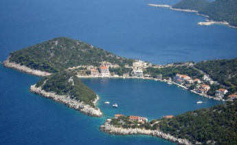
There is only one sizeable settlement on the island, that of Lastovo Town, defended by a hilltop castle. Most of the island’s economy was formerly based on agriculture, especially viticulture, and supplying the needs of the military personnel based there; today tourism is increasingly important. While one would not describe Lastovo as a ‘must see’ destination in the sense of other Croatian national parks, such as the Kornati Islands or the bay of Telascica on Dugi Otok, the island has an understated charm and is a good stopping off point for a yacht arriving from or departing for the Italian coast. There is one main harbour, in the sheltered inlet of Luka Velji Lago, where there is a yacht quay and anchorage, plus additional sheltered anchorages at Mali Lago and Zaklopatica on the N side of the island and Skrivena Luka on the S side.
Charts
- British Admiralty
- 1574
- 2712
- Croatian charts
- MK22
- MK23
- Imray
- M26 (Split to Dubrovnik)
Radio Nets
Also see World Cruiser's Nets.
Weather
Diurnal winds among the Croatian islands are mostly moderate during the summer months, predominantly from NW and rarely exceeding force 4/5, although gusting is common in narrow channels between islands and on the lee side of headlands. At night, katabatic winds off the mountains affect some of the islands close to the mainland coast. During early spring and (especially) autumn conditions can be more unsettled, occasionally accompanied by violent thunderstorms - luckily of short duration - with winds of 30-35 knots or more and vicious, steep seas. In the winter the sudden, violent N wind off the mountains, the bora, is much to be feared, especially along the coast from Rijeka down to Zadar, although its effects can be felt as far south as Split.
Equally prevalent in winter - although not uncommon in summer - is the scirocco, a S/SE wind that blows up from North Africa, usually in advance of a depression moving E across the Mediterranean. Unlike the bora, the scirocco only occasionally exceeds gale force, but is still a phenomenon to be wary of, especially if on a lee coast.
For sources of weather forecasting, see Croatia.
Check-in facilities (Customs and Immigration)
The harbour of Ubli in Velji Lago is a year round port of entry.
Berthing options
There are a total of four berthing options on the island, the main harbour of Velji Lago, which has a ‘mini marina’ at the hamlet of Pasadur operated by the island’s main hotel, Hotel Solitudo, plus a quay at the former military port of Ubli where a yacht can clear in and a snug anchorage on its NW side; an anchorage at Mali Lago on the N side of the island (which is connected to Velji Lago by a shallow small craft channel); a further anchorage at the village of Zaklopatica, also on the N side; and finally a sheltered anchorage at the hamlet of Skrivena at the SE end of the island. Click on link at top right of page for Interactive map of harbours and anchorages or for full details see below.
Ports
Click on link below for details.
Anchorages
For details of the anchorage in Velji Lago, click on link above.
Mali Lago ![]() 42°46.14′N, 16°49.68′E
42°46.14′N, 16°49.68′E
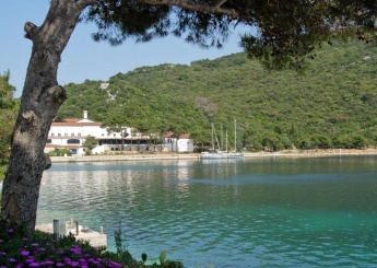
The anchorage of Mali Lago is situated at the top of a winding inlet entered via a mile-long dogleg channel at the NW end of the island. There are several islets and shoal patches to be avoided on the W side of the entrance. The anchorage is at the top of the inlet in depths of 6.0 - 8.0 metres. Holding is good in sand, shingle and weed. The setting here is beautiful, with azure blue water and almost tropical vegetation. A shallow channel spanned by a road bridge connects Mali Lago with the larger inlet of Velji Lago to the S. Shelter in Mali Lago is excellent in all conditions. Restaurants are within walking distance.
Skrivena ![]() 42°43.91′N, 16°53.58′E
42°43.91′N, 16°53.58′E
The anchorage of Skrivena lies towards the SE end of the island. The bay is easily identified by a lighthouse on the headland S of the entrance and a red light structure on the peninsula on the N side. Skrivena is entered from SW and, once around the headland to port, offers perfect shelter in all conditions. Depths in the entrance are 6.0 - 8.0 metres and in the centre of the bay 15.0 metres. Anchor at the head of the bay in 8.0 - 10.0 metres. The holding is good in mud and weed. Alternatively berth on the pontoon of the restaurant called Porto Rosso on the W side of the bay, where there are laid moorings for 30 yachts. Depths here are around 2.5 - 4.0 metres. There is water and electricity on the pontoon. The restaurant has wi-fi, showers and a laundry. The charge for 14.9m in 2015 was 300kn. There is no obligation to eat in the restaurant. A taxi from Porto Rosso to the village of Lastovo costs 90Kn each way (June 2015).
Zaklopatica ![]() 42°46.38′N, 16°52.5′E
42°46.38′N, 16°52.5′E
The anchorage of Zaklopatica lies on the N side of Lastovo Island, in a small bay protected from N by an islet. The entrance channel is to the E of the islet and has depths of 7.0 metres. Shelter in the bay is good in all conditions except strong NE winds, which send in an uncomfortable swell. Anchor at the S end of the bay in 6.0 - 7.0 metres. The holding is good in sand and weed. If you anchor in the north side, take a line baack to the island. Alternatively there are several restaurants on the S shore of the bay which provide moorings on the quay for patrons in depths of 3.0 - 4.0 metres. Both Triton and the rather upmarket Augusta Insula Restaurant, provide waterand electricity for patrons and also produce their own red and white wines.
Offshore Islands
Marinas & Yacht Clubs
None.
Yacht Services and Repairs
None.
Fuel, Water, & Electricity
Fuel berth at quay of Ubli at SE end of Velji Lago bay (0600 - 2200). Water and electricity at Hotel Solitudo quay in Velji Lago and restaurant moorings in Zaklopatica and Skrivenica.
Things to do Ashore
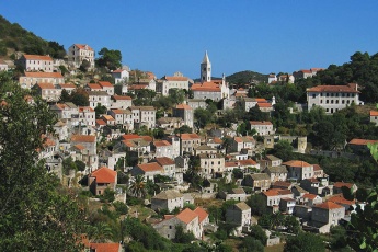
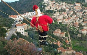
Lastovo Town is an atmospheric place, with narrow alleys lined with old stone houses climbing up the steep slopes of a natural amphitheatre. Practically every square metre that is not built on is cultivated and the village is enveloped with vineyards and vegetable plots. The main 16th century church of Sts Cosman and Damien is well worth a visit and is filled with paintings and artifacts. A unique tradition on the island is the Poklad (Shrove Tuesday) festival, at the culmination of which the population celebrates the memory of the treatment meted out to the messenger of Catalan pirates demanding the island’s surrender. A dummy is lowered down a long rope, with fireworks exploding under its feet, before finally being burned in the town square amidst much merrymaking. How the original messenger responded to this treatment is not recorded …
Transportation
- Regular ferries to Split on mainland from Ubli quay in Velji Lago.
- Seasonal high speed catamaran to Dubrovnik.
- Buses from Ubli to Lastovo Town.
Routes/Passages To/From
Cruiser's Friends
Contact details of "Cruiser's Friends" that can be contacted for local information or assistance.
Forum Discussions
List links to discussion threads on partnering forums. (see link for requirements)
External Links
- The official page of Lastovo Tourist Board
- Lastovo Tourism website
- Augusta Insula Restaurant website
Also see Croatia.
References & Publications
See Croatia.
Personal Notes
Personal experiences?
Last Visited & Details Checked (and updated here)
Date of member's visit to this Port/Stop & this page's details validated:
- July 2005 --Athene of Lymington 16:20, 15 November 2012 (GMT)
- July 2015 -- Zebahdy of London
|
|---|
|
Names: Lighthouse, Athene of Lymington |
| |
|---|
| | HOMEPAGE | Wiki Contents | Southern Europe | Mediterranean | Adriatic Sea | Croatia | Lastovo |


