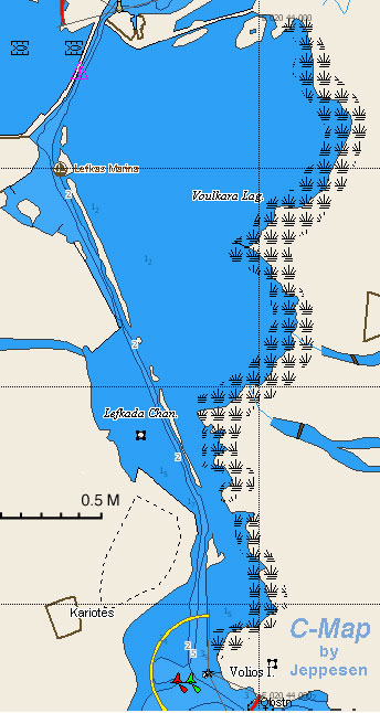
Lefkas Canal
From CruisersWiki
(→Lefkas Canal) |
(→Lefkas Canal) |
||
| Line 12: | Line 12: | ||
| imagetext=Lefkas Canal chartlet | | imagetext=Lefkas Canal chartlet | ||
}}{{TOCleft}} | }}{{TOCleft}} | ||
| - | + | Lefkas Canal runs for around 3.5 miles through the low-lying land at the NE end of the island and divides it from the Greek mainland. | |
| + | |||
| + | The canal, which is dredged to a depth of 5.0 – 6.0 metres along most of its length, is shallow in places, especially at its N entrance, where depths are sometimes little more than 3.5 – 4.0 metres, and about two thirds of the way down from the N, where depths reduce at one point to around 3.5 metres. | ||
| + | |||
| + | The N part of the canal runs between training walls as far as Lefkas Town and is marked by poles (a few of them with red and green markers) for the rest of its length until arriving at the three pairs of buoys at the S end. In places, the channel is quite narrow, and north-going and south-going yachts may be competing for the deeper water in the centre of the channel. | ||
| + | |||
| + | There is a speed limit of 4.0 knots in the canal and sometimes an appreciable current of 1.0 – 1.5 knots, usually S-going. | ||
| + | |||
| + | The road from the mainland passes over the canal at its N end via a floating bridge which opens on the hour from 0600 – 2100 but only on request outside those times. The bridge keeps listening watch on VHF channel 12. | ||
==Charts== | ==Charts== | ||
Revision as of 18:06, 2 March 2015
Lefkas Canal
| Lefkas Canal
| |
North Entrance
| |
South Entrance
| |
|
Lefkas Canal runs for around 3.5 miles through the low-lying land at the NE end of the island and divides it from the Greek mainland.
The canal, which is dredged to a depth of 5.0 – 6.0 metres along most of its length, is shallow in places, especially at its N entrance, where depths are sometimes little more than 3.5 – 4.0 metres, and about two thirds of the way down from the N, where depths reduce at one point to around 3.5 metres.
The N part of the canal runs between training walls as far as Lefkas Town and is marked by poles (a few of them with red and green markers) for the rest of its length until arriving at the three pairs of buoys at the S end. In places, the channel is quite narrow, and north-going and south-going yachts may be competing for the deeper water in the centre of the channel.
There is a speed limit of 4.0 knots in the canal and sometimes an appreciable current of 1.0 – 1.5 knots, usually S-going.
The road from the mainland passes over the canal at its N end via a floating bridge which opens on the hour from 0600 – 2100 but only on request outside those times. The bridge keeps listening watch on VHF channel 12.
Charts
Please provide a good map or chart that clearly shows details (depths, where to dock, scale etc.) of the harbor.
Give charts applicable to this port or refer to a Chart section of another page (Country or Region) that lists the charts.
- Source
- Chart Number - Chart Name
- Chart Number - Chart Name
- Source
- Chart Number - Chart Name
Radio Nets
Also see World Cruiser's Nets.
Entrance 1
Provide any navigation notes especially any dangers or peculiar local conditions here.
Entrance 1
Provide any navigation notes especially any dangers or peculiar local conditions here.
Routes/Passages To/From
List popular passages/routes, timing, etc.
Cruiser's Friends
Contact details of "Cruiser's Friends" that can be contacted for local information or assistance.
Forum Discussions
List links to discussion threads on partnering forums. (see link for requirements)
External Links
List links external to the wiki such as in Wikepedia.
References & Publications
Books, Guides, etc. Use the Reference template or not at your discretion. For example:
-
{{Reference|Rod Heikel|Greek Waters Pilot|Imray Laurie and Wilson, Cambridgeshire|9780852889718}}, expands to - Rod Heikell, Greek Waters Pilot Imray, Laurie and Wilson, Cambridgeshire, ISBN 9780852889718
- Author, Title, Publisher, ISBN ISBN number
- Author, Title, Publisher, ISBN ISBN number
You may want to remove the above entries and use instead a link to the Country or Region that lists the relevant references. If so enter, after removing {{MagentaText|xx}}, the following:
See [[Country or Region#References_&_Publications|Coutry or Region]].
If you do not use the above link, please remove it.
Personal Notes
Personal experiences?
Last Visited & Details Checked (and updated here)
Date of member's visit to this Port/Stop & this page's details validated:
|
|---|
|
Names: |
| |
|---|
| | HOMEPAGE | Wiki Contents | [[Place Page Links Here]] | [[Place Page Links Here]] | [[This Caal]] | |
