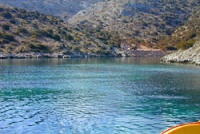
Lipsi
From CruisersWiki
Lipsi
GPS: 37°17.7′N, 26°45.5′E
Background
Lipsi (Λειψοί) is a small but neat island. Its town, and harbor, is very attractive and well kept. It seems that many of today's inhabitants had at one time immigrated to Australia and have now returned. They brought with them a certain amount of affluence and a more cosmopolitan outlook than one would expect on such a small island.
Charts
- BA 2682 Kolpos Patalion to Nisos Nisiros
- BA 3927 Patmos, Arki and Lipso
- Imray-Tetra G34 Southern Cyclades
- NIMA 54400 Samos to Rodhos
- Greek 451 Leros to Rhodos
Radio Nets
Also see Cruiser's Nets
- Coast Guard - VHF channel 12, tel. +30 22470 41 133
- Olympia Radio - channel 24
Approaches to Lipsi are without problems.
Ports and Popular Stops
There are several coves but only one harbor.
Lipsi Harbor
GPS: 37°17.7′N, 26°45.5′E
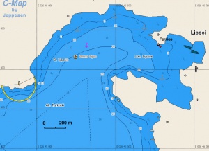
The small harbor of Lipsi (Λειψοί), is at the SW of the island. There is a light (Fl W 3s 6M) at the N entrance. It is very well protected from all the winds but there are very strong gusts during the meltemi. One can moor either stern-to or alongside the new concrete quay or the floating dock.
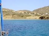
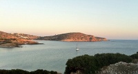
It is also possible to anchor offshore in two small coves just W of the quay one is under a nice church (GPS: 37°17.8′N, 26°45.3′E) and the other is just N of it (GPS: 37°17.9′N, 26°45.5′E) anchor in 6-7 m over sand, good holding.
On the E of the harbor, is a fairly large bay (GPS: 37°17.5′N, 26°45.8′E) that affords excellent protection from the southerlies. The water here is muddy and the bottom is mostly mud and weed. Anchor in 5 m and be sure to test the holding.
The town is a very pleasant with many attractive places to eat, especially in the summer months.
Last Visited & Details Checked (and updated here)
Date of member's visit to this Port/Stop & this page's details validated:
- May 2008 --Istioploos 14:32, 6 June 2008 (MDT)
Anchorages
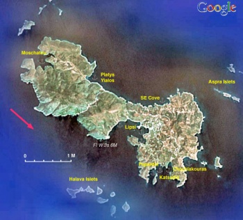
Katsadiá & Papardiá
There are two coves here: Katsadiá (Κατσαδιά) (GPS: 37°16.9′N, 26°46.3′E) and Papardiá (Παπαρδιά) (GPS: 37°16.8′N, 26°46.2′E). These coves are also known as Limni or Lira, because of the little island named Lira (Λύρα) or Lera at its entrance, it is on the southern side of the Lipsi which is not heavily inhabited. Both are a wonderful coves, well protected from the meltemi and have very clear emerald-green waters with a sandy bottom. A few bathers come during the day and there are one or two tents with overnight campers. It is a favorite anchorage of many yachts as there are two other coves near by. Anchor over a patch of sand at 6 m depth on either cove and let out over 45 m of chain just behind Lira. Very good holding (but not everywhere) despite the very strong gusts. One can walk to town about 40 minutes away.
Last Visited & Details Checked (and updated here)Date of member's visit to this Port/Stop & this page's details validated:
|
Platis Yialos
GPS: 37°18.8′N, 26°44.5′E
Platis Yialos or Platys Gialos (Πλατύς Γιαλός) lies at the NE side of the island. It is protected form the Southern wind and from the NW but it is exposed to the NE. It is a very pleasant cove, a bathing favorite of the locals (only 3 km from the town). The bottom is sand and affords good holding. Anchor at 4-5 m. There is a small taverna which operates only during the day.
Last Visited & Details Checked (and updated here)
Date of member's visit to this Port/Stop & this page's details validated:
- October 2008 --Istioploos 13:31, 2 November 2008 (UTC)
Moschatou
GPS: 37°19.2′N, 26°43.2′E
Moschatou (Μοσχάτου) is a very well protected anchorage is on the NW side of the island. It consists of four coves but the N and E are completely taken over by a fish farm. The Southern (GPS: 37°19′N, 26°43.2′E) and the SW afford good all weather protection. Anchor at 5 m and take 2 lines ashore, left and right to prevent the boat to swing to the rocks. A dirt road leads to Platis Yialos.
Last Visited & Details Checked (and updated here)
Date of member's visit to this Port/Stop & this page's details validated:
- May 2004 --Istioploos 14:32, 6 June 2008 (MDT)
Chochlakouras
GPS: 37°17.1′N, 26°47.1′E
This a pleasant enough cove which offers some protection from the meltemi. Anchor on sand in 4-5 m, good holding.
Last Visited & Details Checked (and updated here)
Date of member's visit to this Port/Stop & this page's details validated:
- September 2002 --Istioploos 14:32, 6 June 2008 (MDT)
SE Cove
GPS: 37°18.3′N, 26°46.6′E
This pleasant and deserted cove is exposed to the N and is not a suitable anchorage for the meltemi, it does however offer excellent protection from the S winds. Anchor in 5-6 m over sand, good holding, however I was told by local fishermen that there have been problems here.
Last Visited & Details Checked (and updated here)
Date of member's visit to this Port/Stop & this page's details validated:
- May 2007 --Istioploos 14:32, 6 June 2008 (MDT)
Routes/Passages To/From
Popular passages/routes, timing, etc.
Tourism & things to do ashore
There are no sights here. Just enjoy the beautiful beaches and take long walks.
Fuel, Water, & Electricity
- Fuel - There is a gas station but it is rarely open and only 14:00 to 15:00
- Water - There is an installation at the docks but no service available yet (2007).
- Electricity - At the docks
Laundry
N/A.
Grocery Stores
- A small mini-market near the concrete quay
- Some shopping for provisions up the hill at the village
- A bakery at left of the path to the village
Eateries
- Many restaurants in the harbor, reasonably priced fish at the Theologos.
- At the small square in the village a grill, the Nave, has very good local grilled chicken.
- The small café with blue chairs and tents just to the right of the yacht quay has no name but it is very popular with the locals who call it Nikos'. It serves, in my opinion, the best grilled octopus this side of the Aegean.
Motorbike & Car Rentals
Motorbikes can be rented at the foot of the village.
Marine Stores & Facilities
None.
Repairs
N/A.
Transportation
There are daily hydrofoils in the summer to Kos, Samos, Patmos, and Leros.
References & Publications
See Greece.
Cruiser's Friends
Contact details of "Cruiser's Friends" that can be contacted for local information or assistance.
Forum Discussions
List links to discussion threads on the Cruiser Log Forum
External Links
- Lipsi (Wikipedia)
Personal Notes
Personal experiences?
Last Visited & Details Checked (and updated here)
See individual ports in this page.
| |
|---|
| | HOMEPAGE | Wiki Contents | Mediterranean | Aegean Sea | Greece | Lipsi | |
.
