Los Angeles
From CruisersWiki
Lighthouse (Talk | contribs) |
Lighthouse (Talk | contribs) (→Anchorages) |
||
| Line 71: | Line 71: | ||
===Anchorages=== | ===Anchorages=== | ||
| - | The ports of Los Angeles and Long Beach have set | + | <googlemap lat="33.738616" lon="-118.184052" type="map" zoom="11"> |
| + | 33.759455, -118.181992, Grissom Island | ||
| + | 33.75289, -118.159504, White Island & Anchorage | ||
| + | 33.741185, -118.162594, Freeman Island & Anchorage | ||
| + | 33.739901, -118.13942, Chaffee Island & Anchorage | ||
| + | 33.715344, -118.282413, Cabrillo Anchorage</googlemap> | ||
| + | The ports of Los Angeles and Long Beach have set aside many safe areas for vessel anchorage. | ||
Located within Long Beach Harbor are four man made islands built by the oil consortium THUMS. These islands were built to resemble resort islands to blend in with the surrounding coastal environment. THUMS is a model operation that demonstrates how technology can be used to mitigate the impact of oil operations on sensitive environments. THUMS derived its name from the original consortium of Texaco, Humble, Unocal, Mobil and Shell that operated the field. | Located within Long Beach Harbor are four man made islands built by the oil consortium THUMS. These islands were built to resemble resort islands to blend in with the surrounding coastal environment. THUMS is a model operation that demonstrates how technology can be used to mitigate the impact of oil operations on sensitive environments. THUMS derived its name from the original consortium of Texaco, Humble, Unocal, Mobil and Shell that operated the field. | ||
The four islands, Grissom, White, Chaffee and Freeman, were named after the first astronauts who died in the line of duty early in the U.S. space program. Located between a few hundred yards to 1.5 miles offshore in Long Beach Harbor, they provide a safe haven for vessel anchorage. | The four islands, Grissom, White, Chaffee and Freeman, were named after the first astronauts who died in the line of duty early in the U.S. space program. Located between a few hundred yards to 1.5 miles offshore in Long Beach Harbor, they provide a safe haven for vessel anchorage. | ||
| - | |||
| - | |||
| - | |||
* | * | ||
* | * | ||
Revision as of 08:17, 17 March 2008
Los Angeles (Long Beach)
Background
The history and background of Long Beach, California is best observed on Wikipedia
In recent years, the City of Long Beach has undergone substantial urban redevelopment which started with the revitalization of the Long Beach waterfront including the building of Rainbow Harbor and Shoreline Marina. Today, visitors to Long Beach will find a colorful, vibrant and tourist friendly atmosphere with an endless array of sites, stores, restaurants and entertainment coupled with free public transportation on the water and off. Visit Long Beach
Charts
Submit the chart details that are required for safe navigation.
Radio Nets
The Shoreline Amateur Radio Association (SARA) is a group of Shoreline members who are, or want to be licensed Amateur Radio Operators dedicated to serving Shoreline Yacht Club and the local community through communication and education. SARA operates and maintains Amateur Radio Station K6SYC at Shoreline Yacht Club. SARA also maintains SYC's Marine Radio station, KYL910, in support of SYC's on-the-water activities. SARA also maintains the new K6SYC weather station at the Yacht Club.
Approach
Navigation Details? Permissions for entry?
Check-in facilities
(05/23/2007) From the Official Webpage
How do I report?
Arrivals may be made at any of the locations below. Call the phone number in advance of your arrival to receive specific reporting instructions: Phone-in Arrivals: (562) 366-3200
What information do I have to have when I call?
Vessel masters must have the following information available:
- Name, date of birth and citizenship of all persons on board (including passport number)
- Name of the boat and/or boat registration number
- CBP user fee decal number (if 30 feet or longer)
- Homeport and current location
- Return contact number.
Reporting Locations
- Long Beach/Los Angeles Area Arrivals: Regular hours of service are Monday through Friday 8 a.m. – 5 p.m.
- Parker’s Lighthouse. 435 Shoreline Village Drive, Waterfront, Long Beach, CA
- Pier 202, 1250 Pier F Street, Long Beach, CA
- Port Hueneme/Ventura Area Arrivals: Regular hours of service are Monday through Friday 8 a.m. – 5 p.m.
- Ventura Harbormaster Dock. 1603 Anchorsway Drive, Ventura, CA
Weather
Sources for weather forecasts. Sources of weather forecasting here:
- Weather Underground
- National Oceanic and Atmospheric Administration (NOAA)
- SAILFLOW Weather Where You Sail
Health and Security
?
Marinas & Yacht Clubs
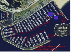
The Long Beach Shoreline (Downtown) Marina opened in 1982 and has 1844 slips for recreational boaters. During 2005 & 2006, Shoreline received a complete renovation with the building of state-of-the-art docks and slips, with cable TV and wireless internet. Shoreline Marina is located between the Queen Mary and the Long Beach Convention Center, in the heart of downtown Long Beach.
- Alamitos Bay Marina
The Alamitos Bay Marina was opened in the late 1950's and early 1960's. There are 1991 slips located throughout the Alamitos Bay area. Alamitos Bay is located in the southeastern corner of Los Angeles County at the intersection of Pacific Coast Highway and Second Street. Guest slips are available at $.75 per foot per night. - Alamitos Bay Yacht Club
- Navy Yacht Club
- Long Beach Yacht Club
- Seal Beach Yacht Club
Routes to/from
Popular routes, timing, etc.
Anchorages
The ports of Los Angeles and Long Beach have set aside many safe areas for vessel anchorage.
Located within Long Beach Harbor are four man made islands built by the oil consortium THUMS. These islands were built to resemble resort islands to blend in with the surrounding coastal environment. THUMS is a model operation that demonstrates how technology can be used to mitigate the impact of oil operations on sensitive environments. THUMS derived its name from the original consortium of Texaco, Humble, Unocal, Mobil and Shell that operated the field.
The four islands, Grissom, White, Chaffee and Freeman, were named after the first astronauts who died in the line of duty early in the U.S. space program. Located between a few hundred yards to 1.5 miles offshore in Long Beach Harbor, they provide a safe haven for vessel anchorage.
Tourism & things to do ashore
Marine stores
Submit addresses and contact details of marine related businesses that are of interest to cruisers.
Offshore Islands
References & Publications
Publications, Guides, etc.
Cruiser's Friends
Contact details of "Cruiser's Friends" that can be contacted for local information or assistance.
Forum Discussions
List links to discussion threads on the Cruiser Log Forum
External Links
Links to relevant websites.
Personal Notes
Personal experiences?
.


