Milwaukee
From CruisersWiki
Milwaukee Cruising Guide
Background
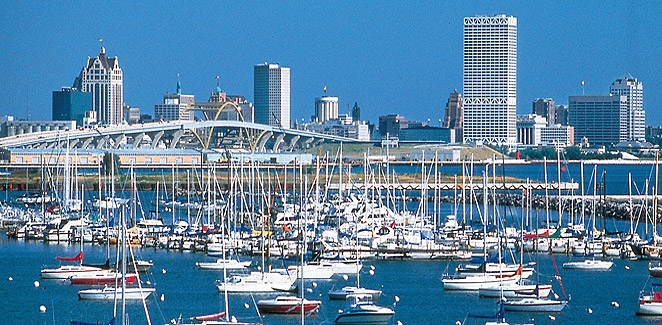
Milwaukee is the largest city in the state of Wisconsin, United States. The city of Milwaukee is the 22nd largest city in the United States. The city is located in the southeastern portion of the state on the western shore of Lake Michigan.
Submit details about the sailing/cruising in the area, etc.
Charts
Submit the chart details that are required for safe navigation.
Radio Nets
Also see Cruiser's Nets
Weather
Local weather conditions?
Sources for Weather forecasts:
United States Coast Pilot 6 2005 (35th edition) Great Lakes
The United States Coast Pilot is published by the National Ocean Service (NOS), National Oceanic and Atmospheric Administration (NOAA), pursuant to the Act of 6 August 1947 (33 U.S.C. 883a and b), and the Act of 22 October 1968 (44 U.S.C. 1310).
Charts 14904, 14924 (692) Milwaukee Harbor, serving the city of Milwaukee, Wis., is one of the major ports on the Great Lakes. The harbor is at the mouth of the Milwaukee River, which flows into Milwaukee Bay, a broad indentation on the W side of Lake Michigan about 80 miles N of Chicago Harbor. The harbor comprises an outer harbor formed by breakwaters paralleling the shore and an inner harbor in Milwaukee River, Menomonee River, and Kinnickinnic River. The principal cargoes handled in the port are general cargo, steel products, coal, cement, and grain. Freighters and petroleum tankers ply the waters year round between this port and other ports on S Lake Michigan.
Prominent features (693) Prominent are lighted television towers 4.5 miles N of the Milwaukee River mouth, the First Wisconsin Center 0.95 mile NNW of the river mouth, a stack 0.4 mile SW of the river mouth, the Allen-Bradley Co. clock and temperature towers 1 mile SW of the river mouth, and an apartment building close SW of the Coast Guard Base at the S end of the outer harbor.
(694) Milwaukee Breakwater Light (43°01.6'N., 87°52.9'W.), 61 feet above the water, is shown from a black lantern on a white square structure on the end of the breakwater on the N side of the main entrance channel; a fog signal is at the light.
Small-craft facilities (743) S of the outer harbor, a series of breakwaters parallels the SW shore of Milwaukee Bay for about 2 miles. The basin thus formed provides good anchorage for small-craft, and gasoline and diesel fuel are available at the yacht club at the N end. The basin may be entered from the S end of the outer harbor, marked by a light, or through a breakwater gap marked by a lighted buoy about 0.7 mile S of the outer harbor. The open S end of the basin and the small breakwater gap 0.45 mile NW should not be used without local knowledge.
(744) The municipal marina at the N end of the outer harbor provides transient berths, gasoline, diesel fuel, water, ice, electricity, sewage pump-out, and launching ramps. A marina on the W side of the mouth of Kinnickinnic River provides gasoline, diesel fuel, sewage pump-out, and marine supplies. A 60-ton stiff-leg crane is available for complete hull and engine repairs. A repair yard on the E side of Kinnickinnic River 1.1 miles above the mouth has a 20-ton hoist and makes hull and small engine repairs. A detached crescent-shaped breakwater, marked at each end by a private day beacon, is 300 feet N of the Municipal Passenger Pier.
Marinas & Yacht Clubs
- McKinley Marina. 1750 N. Lincoln Memorial Drive, Milwaukee, WI 53202. (414) 273-5224
Official Boating Season: May 1–Oct 31
McKinley Marina, Milwaukee County's only public lakefront marina, offers 655 slips with floating docks, security, parking, electricity, water, and many amenities included in the annual rental fee.
Full-service fuel docks with pump-out facilities and a convenience/ships store with marine maintenance and safety supplies are also available.
For tenants' convenience, the award-winning open-air pavilion offers lower-level restroom and shower facilities.
Transient Daily Slip Rentals, 2008 Rates (subject to 5.6% sales tax) = $31.50 + $2.63 per foot over 25 feet.
Anchorages
List details of all safe anchorages in the area.
Offshore Islands
List Islands
Tourism & things to do ashore
List places of interest, tours, etc.
Fuel, Water, & Electricity
Laundry
Grocery & Supply Stores
Eateries
Internet/WiFi
Available?
Motorbike & Car Rentals
Marine Stores & Facilities
Submit addresses and contact details of marine related businesses that are of interest to cruisers.
Repairs
Garbage Disposal
?
Transportation
Transportation (local and/or international)
Routes/Passages To/From
Popular passages/routes, timing, etc.
References & Publications
Publications, Guides, etc.
Cruiser's Friends
Contact details of "Cruiser's Friends" that can be contacted for local information or assistance.
Forum Discussions
List links to discussion threads on partnering forums. (see link for requirements)
External Links
Links to relevant websites.
Personal Notes
Personal experiences?
Last Visited & Details Checked (and updated here)
Date of member's visit to this Port/Stop & this page's details validated:
| This page has an outline in place but needs completing. Please contribute if you can to help it grow further. Click on Comments to suggest further content or alternatively, if you feel confident to edit this page, click on the edit tab at the top and enter your changes directly. |
|
|---|
|
Names: |
| |
|---|
| | HOMEPAGE | Wiki Contents | United States | Great Lakes | Lake Michigan | Milwaukee | |

