Mola di Bari
From CruisersWiki
Lighthouse (Talk | contribs) m (Text replace - "List links to forum discussion threads" to "List links to discussion threads on partnering forums. (see link for requirements)") |
m (Text replace - "==References & Publications==" to "==References==") |
||
| (35 intermediate revisions not shown) | |||
| Line 1: | Line 1: | ||
| - | + | {{IsPartOf|Mediterranean|Adriatic Sea|Italy|Adriatic Coast of Italy}} | |
| - | {| | + | {{TOC block}} |
| - | | | + | |
| - | | | + | |
| - | + | ||
| - | + | ||
| - | + | ||
| - | + | ||
| - | + | ||
| - | + | ||
| - | + | ||
| - | + | ||
| - | + | ||
| - | + | ||
| - | + | ||
| - | + | {{Infobox | |
| - | + | | lat= 41.05987|lon=17.0992 | |
| - | + | | name= Mola di Bari | |
| + | | portofentry= | ||
| + | | zoom= 15 | ||
| + | | chartlet = y | ||
| + | | image= MolaBariHarbour.jpg | ||
| + | | imagetext= Mola di Bari harbour from NE (the E breakwater is out of the picture) | ||
| + | | summary= Mola di Bari is a small fishing and yacht harbour on the Adriatic coast of [[Italy]] 65 miles NW of the port of [[Brindisi]] and 12 miles SE of the larger harbour of [[Bari]]. While frequently crowded, it is usually possible for a medium-sized yacht of up to about 15 metres to squeeze in somewhere here. At peak times (and for yachts much over 15 metres), [[Bari]] is a better proposition two hours to the NW. Shelter is very good here following the completion several years ago of a new 700 metre eastern breakwater protecting the harbour from easterlies. | ||
| + | | notes= | ||
| + | | news= | ||
| + | }} | ||
==Charts== | ==Charts== | ||
| - | + | ; British Admiralty | |
| - | ; | + | : 186 Vlore to Bar and Brindisi to Vieste |
| - | : | + | ; Italian charts |
| - | : | + | : 921 |
| + | : 30 From Torre Scanzano to Taranto, with the Armeleia Shallows | ||
| + | : 196 | ||
| - | == | + | ==Weather== |
| - | + | During the summer months, the prevailing winds in the Adriatic are light to moderate coastal sea breezes. In spring and autumn, northerly winds are more frequent and can quickly rise to near gale force, especially in the northern Adriatic, where the much-feared “bora” is caused by high pressure over the mountains to the NE coupled with low pressure over southern Italy. Fortunately, the fiercest “bora” is normally to be expected in the winter months. Thunderstorms are occasionally experienced in spring and especially autumn and can be accompanied by violent winds of gale force and above. Luckily they are rarely long-lasting. In the southern Adriatic, the “scirocco”, a S/SE wind blowing up from North Africa which can last for several days, is more common. Unlike the “bora”, which can arrive without warning, a “scirocco” tends to build in strength over 24-48 hours, sometimes reaching gale force (especially in winter). | |
| - | * | + | |
| + | Sources for weather information: | ||
| + | * There is a continuous (computerized voice) weather forecast on VHF 68 - first in Italian and then followed with an English translation | ||
| + | * The same forecast is given in Italian and English on VHF coastal stations following a notification on channel 16 | ||
| + | * Navtex weather forecasts covering the Adriatic are broadcast from stations at Roma, Trieste, Kerkyra (Greece) and Split (Croatia) | ||
| - | == | + | ==Passages== |
| - | + | ''See [[Adriatic_Sea#Passages|Adriatic]]''. | |
| - | + | ==Communication== | |
| + | {{Green|Add here VHF channel for the coastguard, harbor masters. etc.}} | ||
* | * | ||
| + | * | ||
| - | + | ''Also see [[World MM Nets|World Cruiser's Nets]]''. | |
| - | + | ||
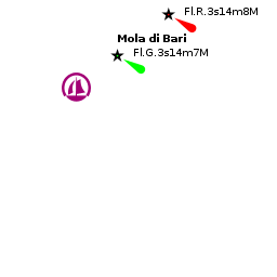
| - | == | + | ==Navigation== |
| - | + | A church with a distinctive onion-shaped dome is conspicuous SE of the harbour entrance. Entry to the outer harbour is from NNW between the long eastern breakwater and the western breakwater that encloses the inner harbour. Depths in the entrance are 5.5 - 7.0 metres. Once through the outer entrance, turn sharply to starboard to enter the inner harbour, taking care to stay no more than 20 - 30 metres off the western breakwater (but not too close because of ballasting). There is a shoal patch of less than 1.5 metres extending nearly 100 metres NE from the short, inner breakwater that is a trap for the unwary. Depths in the safe, starboard side of the channel into the inner harbour are 3.5 - 5.0 metres. | |
| - | == | + | ==Berthing== |
| - | + | Vising yachts normally berth where directed on the pontoons in the inner harbour, which are operated by the [[#Circolo Nautico Daphne|Circolo Nautico Daphne]]. An alternative options for shallow draught vessels is the pontoon in the outer harbour operated by the Italian [[#Lega Navale|Lega Navale]], which extends E from the root of the inner breakwater. | |
| - | + | ||
| - | + | ||
| - | ==Marinas & Yacht Clubs== | + | ===Marinas & Yacht Clubs=== |
| - | + | {{poi | lat= 41.06129| lon=17.09445 | |
| - | + | | type= marina | |
| - | + | | name= Circolo Nautico Daphne | |
| + | | altname= | ||
| + | | url = http://circolonauticodaphne.it | ||
| + | | zoom= 17 | ||
| + | | portofentry= | ||
| + | | image= | ||
| + | | imagetext= | ||
| + | | text= Depths here vary from 2.0 metres at the root to 3.5 metres at the end. Laid moorings at all berths. | ||
| + | : {{email|[email protected]}}; Tel/Fax: {{phone|39|080|4736419}}; Mobile: {{mob|39|347|40 77 399}}; VHF channel XX | ||
| + | : Address: Via Lungara Porto 13, 70042 Mola Di Bari (Ba), Italy | ||
| + | }} | ||
| + | |||
| + | {{poi | lat= 41.05934| lon=17.09762 | ||
| + | | type= marina | ||
| + | | name= Lega Navale | ||
| + | | altname= | ||
| + | | url = http://www.leganavale.it/strutture/Mola_di_bari | ||
| + | | zoom= 17 | ||
| + | | portofentry= | ||
| + | | image= | ||
| + | | imagetext= | ||
| + | | text= Depths at the pontoons are 1.5 - 2 metres. If there is no space on the pontoons, yachts are also permitted to berth alongside the western breakwater, where depths range from 2.0 metres at the root to 4.5 metres along the outer section. This is, however, sometimes full of fishing boats. | ||
| + | : {{email|[email protected]}}; Tel: {{phone|39|080|474 6465}}; Fax: {{fax|39|080|471 4021}}; VHF channel XX | ||
| + | : Address: Cala Loreto Porto, 70042 Mola di Bari (BA), Italy | ||
| + | }} | ||
==Anchorages== | ==Anchorages== | ||
| - | + | In settled weather, a small yacht could anchor in the SE corner of the outer harbour in depths of 3.5 - 4.0 metres. Holding is good in sand and mud. A second anchor might be necessary at avoid swinging into the shallows inshore or the fairway. The outer harbour is completely open to any winds or swell from NW round to NE. | |
| - | + | ||
| - | + | ||
| - | + | ||
| - | == | + | ==Amenities== |
| - | + | {{tlist | |
| - | + | ||
| - | + | ||
| - | + | |header|Facilities | |
| - | + | ||
| - | + | |Water| On the pontoons | |
| - | + | |Electricity| On the pontoons | |
| - | + | |Toilets| {{MagentaText|?}} | |
| - | + | |Showers| {{MagentaText|?}} | |
| - | + | |Laundry| N/A (Not Available) | |
| - | + | |Garbage| Bins near the harbour | |
| - | + | ||
| - | + | |header|Supplies | |
| - | + | |Fuel| On the inner breakwater (telephone for supplies) | |
| - | + | |Bottled gas| {{MagentaText|?}} | |
| - | + | |Chandlers| None | |
| - | + | |header|Services | |
| - | + | |Repairs| Slipway. Fixed crane (300 T). Travel lift (100 T). Some hard standing. Engine, electrical and electronic repairs. Wood, fiberglass and steel hull repairs. Divers | |
| - | + | |Internet| {{MagentaText|?}} | |
| + | |Mobile connectivity| {{MagentaText|?}} | ||
| + | |Vehicle rentals| Rental outlets in the town | ||
| + | }} | ||
| - | === | + | ==Provisioning== |
| - | + | Numerous provisions shops in the town. | |
| - | + | ||
| - | == | + | ==Eating out== |
| - | + | Restaurants and pizzerias around the harbour and in the town. | |
| - | == | + | ==Transportation== |
| - | * | + | * Buses to Grotte di Castellana and other local destinations. |
| - | * | + | * Local and international flights from Bari airport (30 kms). |
| + | * Trains to [[Bari]], [[Brindisi]] and connections to most major cities. | ||
| - | == | + | ==Tourism== |
| - | + | {{Image right|MolaCastle.jpg | Angiovin castle of Mola di Bari< }} | |
| + | {{Image right|MolaMatrice.jpg |Chiesa Matrice, Mola di Bari }} | ||
| - | + | There is not a great deal of tourist interest in Mola di Bari other than a squat, 16th century Angiovin castle built on the harbour by Charles I of Anjou and the Chiesa Matrice, a church dating back o the 13th century. The old town still retains its mediaeval street plan and is fun to explore. With transport, one can also visit the impressive cave system of Grotte di Castellana and the World Heritage site of Alberobello with its unique ''trulli'' houses. | |
| - | + | ||
| - | + | ||
| - | + | ||
| - | + | ||
| - | + | ||
| - | + | ||
| - | + | ||
| - | + | ||
| - | + | ||
| - | == | + | ==Friends== |
Contact details of "Cruiser's Friends" that can be contacted for local information or assistance. | Contact details of "Cruiser's Friends" that can be contacted for local information or assistance. | ||
* | * | ||
| - | == | + | ==Forums== |
| - | List links to discussion threads on [[Cruising Forums|partnering forums]]. (see link for | + | List links to discussion threads on [[Cruising Forums|partnering forums]]. (''see link for requirement''s) |
* | * | ||
| + | |||
| + | ==Links== | ||
| + | * {{wikipedia}} | ||
| + | * {{Wikivoyage}} | ||
* | * | ||
| - | + | ||
| + | ==References== | ||
| + | ''See [[Italy#References_&_Publications|Italy]]''. | ||
| - | + | {{Comments}} | |
| - | + | ||
* | * | ||
| - | |||
| - | |||
| - | + | {{Verified by}} | |
| - | + | * May 2005 --[[User:Atheneoflymington|Athene of Lymington]] 14:11, 27 December 2010 (UTC) | |
* | * | ||
| - | |||
| - | |||
| - | |||
| - | |||
| - | |||
| - | |||
| - | + | {{Page useable}} | |
| - | + | ||
| - | + | ||
| - | {{ | + | {{Contributors|[[User:Lighthouse|Lighthouse]], [[User:Atheneoflymington|Athene of Lymington]]}} |
| - | + | [[Category:Ports - Italy]] [[Category:Marinas - Italy]] [[Category:Anchorages - Italy]] | |
| - | + | ||
| - | + | ||
| - | + | ||
| - | + | ||
| - | + | ||
| - | + | ||
| - | + | ||
| - | [[Category: | + | |
| - | + | ||
| - | + | ||
| - | + | ||
Latest revision as of 12:06, 15 August 2018
| Mola di Bari
| |
| |
 Mola di Bari harbour from NE (the E breakwater is out of the picture) |
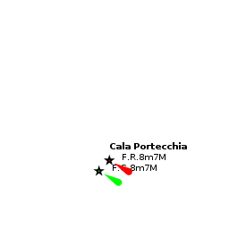
Mola di Bari is a small fishing and yacht harbour on the Adriatic coast of Italy 65 miles NW of the port of Brindisi and 12 miles SE of the larger harbour of Bari. While frequently crowded, it is usually possible for a medium-sized yacht of up to about 15 metres to squeeze in somewhere here. At peak times (and for yachts much over 15 metres), Bari is a better proposition two hours to the NW. Shelter is very good here following the completion several years ago of a new 700 metre eastern breakwater protecting the harbour from easterlies.
Charts
- British Admiralty
- 186 Vlore to Bar and Brindisi to Vieste
- Italian charts
- 921
- 30 From Torre Scanzano to Taranto, with the Armeleia Shallows
- 196
Weather
During the summer months, the prevailing winds in the Adriatic are light to moderate coastal sea breezes. In spring and autumn, northerly winds are more frequent and can quickly rise to near gale force, especially in the northern Adriatic, where the much-feared “bora” is caused by high pressure over the mountains to the NE coupled with low pressure over southern Italy. Fortunately, the fiercest “bora” is normally to be expected in the winter months. Thunderstorms are occasionally experienced in spring and especially autumn and can be accompanied by violent winds of gale force and above. Luckily they are rarely long-lasting. In the southern Adriatic, the “scirocco”, a S/SE wind blowing up from North Africa which can last for several days, is more common. Unlike the “bora”, which can arrive without warning, a “scirocco” tends to build in strength over 24-48 hours, sometimes reaching gale force (especially in winter).
Sources for weather information:
- There is a continuous (computerized voice) weather forecast on VHF 68 - first in Italian and then followed with an English translation
- The same forecast is given in Italian and English on VHF coastal stations following a notification on channel 16
- Navtex weather forecasts covering the Adriatic are broadcast from stations at Roma, Trieste, Kerkyra (Greece) and Split (Croatia)
Passages
See Adriatic.
Communication
Add here VHF channel for the coastguard, harbor masters. etc.
Also see World Cruiser's Nets.
A church with a distinctive onion-shaped dome is conspicuous SE of the harbour entrance. Entry to the outer harbour is from NNW between the long eastern breakwater and the western breakwater that encloses the inner harbour. Depths in the entrance are 5.5 - 7.0 metres. Once through the outer entrance, turn sharply to starboard to enter the inner harbour, taking care to stay no more than 20 - 30 metres off the western breakwater (but not too close because of ballasting). There is a shoal patch of less than 1.5 metres extending nearly 100 metres NE from the short, inner breakwater that is a trap for the unwary. Depths in the safe, starboard side of the channel into the inner harbour are 3.5 - 5.0 metres.
Berthing
Vising yachts normally berth where directed on the pontoons in the inner harbour, which are operated by the Circolo Nautico Daphne. An alternative options for shallow draught vessels is the pontoon in the outer harbour operated by the Italian Lega Navale, which extends E from the root of the inner breakwater.
Marinas & Yacht Clubs
Circolo Nautico Daphne
Depths here vary from 2.0 metres at the root to 3.5 metres at the end. Laid moorings at all berths.
- [email protected]; Tel/Fax: +39 (080) 4736419; Mobile: +39 (347) 40 77 399; VHF channel XX
- Address: Via Lungara Porto 13, 70042 Mola Di Bari (Ba), Italy
Depths at the pontoons are 1.5 - 2 metres. If there is no space on the pontoons, yachts are also permitted to berth alongside the western breakwater, where depths range from 2.0 metres at the root to 4.5 metres along the outer section. This is, however, sometimes full of fishing boats.
- [email protected]; Tel: +39 (080) 474 6465; Fax: +39 (080) 471 4021; VHF channel XX
- Address: Cala Loreto Porto, 70042 Mola di Bari (BA), Italy
Anchorages
In settled weather, a small yacht could anchor in the SE corner of the outer harbour in depths of 3.5 - 4.0 metres. Holding is good in sand and mud. A second anchor might be necessary at avoid swinging into the shallows inshore or the fairway. The outer harbour is completely open to any winds or swell from NW round to NE.
Amenities
| Facilities | |
|---|---|
| Water | On the pontoons |
| Electricity | On the pontoons |
| Toilets | ? |
| Showers | ? |
| Laundry | N/A (Not Available) |
| Garbage | Bins near the harbour |
| Supplies | |
| Fuel | On the inner breakwater (telephone for supplies) |
| Bottled gas | ? |
| Chandlers | None |
| Services | |
| Repairs | Slipway. Fixed crane (300 T). Travel lift (100 T). Some hard standing. Engine, electrical and electronic repairs. Wood, fiberglass and steel hull repairs. Divers |
| Internet | ? |
| Mobile connectivity | ? |
| Vehicle rentals | Rental outlets in the town |
Provisioning
Numerous provisions shops in the town.
Eating out
Restaurants and pizzerias around the harbour and in the town.
Transportation
- Buses to Grotte di Castellana and other local destinations.
- Local and international flights from Bari airport (30 kms).
- Trains to Bari, Brindisi and connections to most major cities.
Tourism


There is not a great deal of tourist interest in Mola di Bari other than a squat, 16th century Angiovin castle built on the harbour by Charles I of Anjou and the Chiesa Matrice, a church dating back o the 13th century. The old town still retains its mediaeval street plan and is fun to explore. With transport, one can also visit the impressive cave system of Grotte di Castellana and the World Heritage site of Alberobello with its unique trulli houses.
Friends
Contact details of "Cruiser's Friends" that can be contacted for local information or assistance.
Forums
List links to discussion threads on partnering forums. (see link for requirements)
Links
- Mola di Bari at the Wikipedia
- Mola di Bari at the Wikivoyage
References
See Italy.
Comments
We welcome users' contributions to the Wiki. Please click on Comments to view other users' comments, add your own personal experiences or recommend any changes to this page following your visit.
Verified by
Date of member's last visit to Mola di Bari and this page's details validated:
- May 2005 --Athene of Lymington 14:11, 27 December 2010 (UTC)
| This is a usable page of the cruising guide. However, please contribute if you can to help it grow further. Click on Comments to add your personal notes on this page or to discuss its contents. Alternatively, if you feel confident to edit the page, click on the edit tab at the top and enter your changes directly. |
| |
|---|
|
Names: Lighthouse, Athene of Lymington |