Noumea
From CruisersWiki
Peter McHugh (Talk | contribs) (Added Approach and navigation info) |
Peter McHugh (Talk | contribs) |
||
| Line 41: | Line 41: | ||
'''Passe De La Havannah''' | '''Passe De La Havannah''' | ||
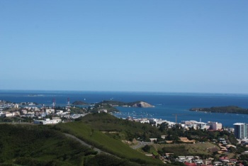
| + | [[Image:Cap_Ndoua.jpg|350px|thumb|right|Cap Ndoua. The leads for Havannah Pass are visible on the hillside.<br/>''Click for larger view'']] | ||
Vessels arriving from the east, generally either from Vanuatu or Fiji usually enter at Passe De La Havannah. This Pass is approximately 2 nm wide, but is a very long way from the nearest land and is subject to strong and dangerous tidal flows that should be taken into account on approach. There are currently obvious wrecks on the reef that show what happens if you get it wrong. | Vessels arriving from the east, generally either from Vanuatu or Fiji usually enter at Passe De La Havannah. This Pass is approximately 2 nm wide, but is a very long way from the nearest land and is subject to strong and dangerous tidal flows that should be taken into account on approach. There are currently obvious wrecks on the reef that show what happens if you get it wrong. | ||
Revision as of 08:12, 3 July 2011
Noumea (Port of entry)
| | |
| | DD°M.M′N/S, DD°M.M′E/W |
|---|---|
| | [ Photo gallery] |
| | [ Local chartlet] |
Island description, etc.
Submit details about the sailing/cruising in the area, etc.
Charts
Submit the chart details that are required for safe navigation.
- Chart Source
- Chart Number
Radio Nets
Also see Cruiser's Nets
Weather
Local weather conditions?
Sources for Weather forecasts:
There are two main approaches to Noumea, depending on whether you are arriving from the East or West.
Passe De La Havannah
Vessels arriving from the east, generally either from Vanuatu or Fiji usually enter at Passe De La Havannah. This Pass is approximately 2 nm wide, but is a very long way from the nearest land and is subject to strong and dangerous tidal flows that should be taken into account on approach. There are currently obvious wrecks on the reef that show what happens if you get it wrong.
Note should be taken of the relatively shallow Banc Du Coetlogon some 4 nm to seaward of Havannah. While adequately deep, it may produce difficult seas in unfavourable conditions.
Tide times at Havannah are one hour ahead of Noumea. The tide flow can reach 4 knots and, with unfavourable winds or swell, significant and dangerous overfalls can develop. It is very preferable to enter Havannah at slack water if at all possible.
Havannah Pass is well marked, but, because of the distances involved, the marks / lights may not be obvious to a navigator approaching from seaward in poor visibility. The main marks are the leads on Cap Ndoua, which provide 3 white lead makers defining the Havannah entrance. Note that, when you are in the Pass, you are still over 8 nm from the leads. The Goro light is on the northern side of the Pass.
Once through the Pass, there are clear navigation markers which allow you to round Cap Ndoua, traverse Canal Woodin and carry on north to Noumea. Note that the tide flows through Canal Woodin can be substantial and overfalls are possible in the vicinity of Pointe Noukouma at the western end.
Passe De Boulari
Arrival from the West is through Passe De Boulari. The Passe is narrow (1/3 nm) but well marked. The historic Amedee Light has a range of 20nm and forms part of the pair of lead lights for the entrance. Once inside the Pass, the track to Noumea is clearly marked
On arrival, vessels are expected to continue directly to Noumea for clearance, without stopping. If you arrive at night, you should anchor outside Port Moselle and arrange clearnace through the Port Captain the next morning. You should not proceed into the marina at night.
Check-in facilities (Customs and Immigration)
Submit details about facilities for checking in - where to dock, location of immigration & customs, etc.
Ports and Popular Stops
Ports
- Port Moselle (Port of entry)
Anchorages
List details of all safe anchorages in the area.
Marinas & Yacht Clubs
Also see each Port
Yacht Services and Repairs
Also see each Port
Marine Stores
Submit addresses and contact details of marine related businesses that are of interest to cruisers.
Yacht Services/Repairs/Yards
Fuel, Water, & Electricity
- Fuel
- Give details on fuel
- Water
- Give details on water
- Electricity
- Give details on electricity
Offshore Islands
List Islands
Tourism and Things to do Ashore
Tourism
List places of interest, tours, etc.
Grocery & Supply Stores
Eateries
Internet/WiFi
Available?
Laundry
Motorbike & Car Rentals
Garbage Disposal
?
Transportation
Transportation (local and/or international)
Routes/Passages To/From
Popular passages/routes, timing, etc.
Cruiser's Friends
Contact details of "Cruiser's Friends" that can be contacted for local information or assistance.
Forum Discussions
List links to discussion threads on partnering forums. (see link for requirements)
External Links
Links to relevant websites.
References & Publications
Publications, Guides, etc.
Personal Notes
Personal experiences?
Last Visited & Details Checked (and updated here)
Date of member's visit to this Port/Stop & this page's details validated:
| |
|---|
| | HOMEPAGE | Wiki Contents | South Pacific | New Caledonia | Noumea | |

