Pescara
From CruisersWiki
Istioploos (Talk | contribs) (Headings) |
m (Text replace - "#References & Publications|" to "#References|") |
||
| (36 intermediate revisions not shown) | |||
| Line 1: | Line 1: | ||
| - | + | {{IsPartOf|Mediterranean|Adriatic Sea|Italy|Adriatic Coast of Italy}} | |
| - | { | + | {{TOC block}} |
| - | + | ||
| - | + | ||
| - | | | + | |
| - | + | ||
| - | | | + | |
| - | + | ||
| - | + | ||
| - | + | ||
| - | + | ||
| - | + | ||
| - | + | ||
| - | + | ||
| - | + | ||
| - | + | ||
| - | The city of Pescara lies on the Adriatic coast of [[Italy]] around 12 miles NW of the port of [[Ortona]] and 22 miles SE of [[Giulianova]], at the mouth of the river of the same name. | + | {{Infobox |
| + | | lat= 42.4661| lon=14.2345 | ||
| + | | name= Pescara | ||
| + | | portofentry= y | ||
| + | | zoom= 14 | ||
| + | | chartlet = y | ||
| + | | image= PescaraAerial.jpg | ||
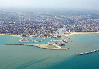
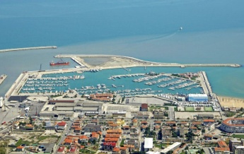
| + | | imagetext= Pescara harbour from NE, showing the marina and Porto Canale | ||
| + | | summary= The city of '''Pescara''' lies on the Adriatic coast of [[Italy]] around 12 miles NW of the port of [[Ortona]] and 22 miles SE of [[Giulianova]], at the mouth of the river of the same name. The city has been substantially rebuilt and is a popular summer resort. It hosts every July an internationally famous jazz festival and also boasts one of the largest marinas along the central Adriatic coast, the [[Marina di Pescara]] with over 1000 berths, as well as further moorings for smaller yachts (mostly occupied by local vessels) at the [[#Porto Canale|Porto Canale]] in the canalised River Pescara. | ||
| + | | notes= | ||
| + | | news= | ||
| + | }} | ||
==Charts== | ==Charts== | ||
| Line 26: | Line 23: | ||
: 211 | : 211 | ||
| - | == | + | ==Weather== |
| - | + | During the summer months, the prevailing winds in the Adriatic are light to moderate coastal sea breezes. In spring and autumn, northerly winds are more frequent and can quickly rise to near gale force, especially in the northern Adriatic, where the much-feared “bora” is caused by high pressure over the mountains to the NE coupled with low pressure over southern Italy. Fortunately, the fiercest “bora” is normally to be expected in the winter months. Thunderstorms are occasionally experienced in spring and especially autumn and can be accompanied by violent winds of gale force and above. Luckily they are rarely long-lasting. In the southern Adriatic, the “Scirocco”, a S/SE wind blowing up from North Africa which can last for several days, is more common. Unlike the “bora”, which can arrive without warning, a “scirocco” tends to build in strength over 24-48 hours, sometimes reaching gale force (especially in winter). | |
| - | + | ||
| - | + | ||
| - | + | ||
| - | + | Fog is also a common problem along the coast, especially in the early morning, although it usually clears by early afternoon. | |
| - | + | ||
Sources for weather information: | Sources for weather information: | ||
| - | * There is a continuous ( | + | * There is a continuous (computerized voice) weather forecast on VHF 68 - first in Italian and then followed with an English translation |
* The same forecast is given in Italian and English on VHF coastal stations following a notification on channel 16 | * The same forecast is given in Italian and English on VHF coastal stations following a notification on channel 16 | ||
* Navtex weather forecasts covering the Adriatic are broadcast from stations at Roma, Trieste, Kerkyra (Greece) and Split (Croatia) | * Navtex weather forecasts covering the Adriatic are broadcast from stations at Roma, Trieste, Kerkyra (Greece) and Split (Croatia) | ||
| - | == | + | ==Passages== |
| - | + | ''See [[Adriatic_Sea#Passages|Adriatic]]''. | |
| - | + | ==Islands== | |
| + | * [[Tremiti Islands]] | ||
| - | + | ==Communication== | |
| + | {{Green|Add here VHF channel for the coastguard, harbor masters. etc.}} | ||
| + | * | ||
| + | * | ||
| - | + | ''Also see [[World MM Nets|World Cruiser's Nets]]''. | |
| - | == | + | ==Navigation== |
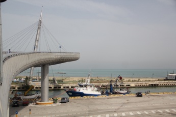
| - | + | {{Image right| PescaraBridge.JPG| Clearance under the new footbridge is only 14.5 metres }} | |
| - | + | ||
| - | + | The town of Pescara straddles its own river and can be identified from distance by a cluster of tall aerials on the hills behind. Closer in, the buildings of the city and the long detached breakwater protecting the harbour will be seen. A tall white-painted lighthouse is also conspicuous on the S bank of the canalized entrance to the river. | |
| - | + | To enter the [[#Porto Canale|Porto Canale]] pass either side of the detached breakwater and head for the channel between the two training walls, leaving the green buoy marking a shoal patch to starboard. The berthing areas lie around half a mile up the channel to port and starboard below the road bridge. Depths in the Porto Canale are 3.5 - 4.0 metres and along the quays 2.5 - 4.5 metres. The channel is narrow and care is needed on entry (fishing vessels tear in and out). Important note: a new pedestrian footbridge at the end of the entrance channel restricts access to yachts with a maximum air draft of 14.5 metres. | |
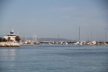
| - | + | {{Image right| PescaraEntrance.JPG| The four buoys mark the port side of the entrance channel to Marina di Pescara }} | |
| - | + | ||
| - | + | To enter the [[Marina di Pescara]] pass to the SE end of the curved breakwater that protects the marina, which will be evident from the numerous yacht masts. The marina is entered from SSE between this breakwater and a short western mole. It is important to pass down the ''centre'' of the channel bounded on the W side by a series of four orange buoys and on the E side by the marina breakwater, leaving each buoy about 10 metres to port. Depths in the channel are variable between 2.5 and 3.5 metres and if in doubt call the marina on channel 06 and a RIB will guide you in. Yachts drawing over 2.5 metres should not attempt to enter. | |
| - | + | ||
| - | + | {{Note}}Strong northerly winds can make entry difficult or even dangerous to both the Porto Canale and the marina. | |
| - | + | ||
| - | == | + | ==Entrance== |
| - | + | [[{{PAGENAME}}]] is a port of entry for Italy. For details ''see [[Italy#Entrance|Entrance: Italy]]''. | |
| - | + | ||
| - | + | ||
| - | + | Personal experience checking into Pescara October 2016... we arrived from Croatia, called Marina di Pescara on the VHF radio to inform them of our arrival into the country. | |
| - | + | We had previously booked our berth & notified them of our intention to winter our boat here, so they were expecting us. | |
| + | |||
| + | Almost as soon as we were secured into the marina berth, officials from Customs and Immigration showed up at our boat. I have no information to offer about the location of their office other than that they were very helpful and pleasant to deal with. They processed our paperwork and stamped our passports/cleared us in there at the dock. They did not board our vessel. | ||
| - | + | Shortly after that, the marina manager informed us that we needed to go to the Coast Guard office which was a few kilometers away just up the river. He actually drove us to the office, dropped us off and we walked back to the marina after we cleared in with Guardia di Finanza and the Coast Guard. The entire process from arrival at the marina to finishing up at this office took no longer than a couple of hours. --[[User:Barbjgladney|Barbjgladney]] 19:20, 4 June 2017 (BST) | |
| - | + | {{hold vertical}} | |
| - | == | + | ==Berthing== |
| - | ==== | + | {{poi | lat= 42.46631| lon=14.22455 |
| - | + | | type= harbour | |
| + | | name= Porto Canale | ||
| + | | altname= | ||
| + | | url = | ||
| + | | zoom= 16 | ||
| + | | portofentry= y | ||
| + | | image=PescaraCircoloNautico.JPG | ||
| + | | imagetext= Yacht club berths in the Porto Canale | ||
| + | | text= In the Porto Canale, a small visiting yacht with suitable air draft may find a berth on the N quay, wherever there is space. Most of the N quay is reserved for concessionaires L'Ancora, Circolo Nautico Mimadea Club and Club Nautico Porto Canale and it is usually necessary to seek permission from them to take up a berth. There are electricity and water points at the club berths. The remainder of the N quay and all of the S quay are reserved for fishing boats. | ||
| + | : {{email| [email protected]}}; Tel: {{phone|39|085|694 040}}; VHF channels 12 & 16 | ||
| + | }} | ||
| + | {{hold vertical}} | ||
| + | ===Marinas & Yacht Clubs=== | ||
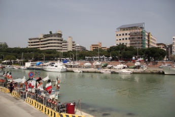
| + | {{Image right| PescaraMarina.jpg| Marina di Pescara from SW }} | ||
| - | [[ | + | * [[Marina di Pescara]] |
| - | == | + | ==Anchorages== |
| - | + | No anchoring is permitted in the harbour. | |
| - | + | ||
| - | ==== | + | ==Amenities== |
| - | + | {{tlist | |
| - | + | ||
| - | + | |header|Facilities | |
| - | + | ||
| - | + | |Water| Water in the [[Marina di Pescara|marina]] and [[#Porto Canale|Porto Canale]] | |
| - | + | |Electricity| Eelectricity in the [[Marina di Pescara|marina]] and [[#Porto Canale|Porto Canale]] | |
| + | |Toilets| In the [[Marina di Pescara|marina]] | ||
| + | |Showers| In the [[Marina di Pescara|marina]] | ||
| + | |Laundry| | ||
| + | [[Marina di Pescara]] has a fairly new onsite self-service laundry facility. The washer €4 per load, including soap. Dryer costs €1/10 minutes | ||
| + | --[[User:Barbjgladney|Barbjgladney]] 19:30, 4 June 2017 (BST) | ||
| - | + | |Garbage| Bins at the Porto Canale and in [[Marina di Pescara]] | |
| - | + | ||
| - | |||
| - | |||
| - | ==== | + | |header|Supplies |
| + | |Fuel| Fuel station in the [[Marina di Pescara|marina]] | ||
| + | |Bottled gas| {{MagentaText|?}} | ||
| + | |Chandlers| In the [[Marina di Pescara|marina]] | ||
| + | |||
| + | |header|Services | ||
| + | |Repairs| In Porto Canale: Slipway. Mobile crane (120 T). Wooden hull repairs. Divers. For details of marina yard services, see [[Marina di Pescara]] | ||
| + | |Internet| WiFi in the [[Marina di Pescara|marina]] | ||
| + | |Mobile connectivity| {{MagentaText|?}} | ||
| + | |Vehicle rentals| Numerous rental outlets in the city | ||
| + | }} | ||
| + | |||
| + | ==Provisioning== | ||
| + | * ''Conad'' supermarket 15 minutes from marina, half way down Viale Amerigo Vespucci | ||
| + | * ''Vodafone'', 3 and ''Wind'' mobile 'phone shops in Viale Guglielmo Marconi | ||
| + | |||
| + | ==Eating out== | ||
| + | * ''Filippo'' fish restaurant half way along Viale Amerigo Vespucci (and close to ''Conad'' supermarket) is excellent value and much frequented by locals | ||
| + | * ''Guerino'' is my favorite fish restaurant in Pescara. Worth a trip. --[[User:Istioploos|Istioploos]] | ||
| + | * Several restaurants and café/bars in the marina | ||
| + | |||
| + | ==Transportation== | ||
* Buses to most local destinations from the city. Direct buses to Rome. | * Buses to most local destinations from the city. Direct buses to Rome. | ||
* Railway stations (three) with connections to most destinations. | * Railway stations (three) with connections to most destinations. | ||
| Line 110: | Line 136: | ||
* Ferries and hydrofoils to [[Croatia]]. | * Ferries and hydrofoils to [[Croatia]]. | ||
| - | == | + | ==Tourism== |
| - | + | ====History==== | |
| - | + | In antiquity Pescara was named Aternum and was an important port for trade between Rome and the eastern empire, being connected to the capital by the Via Tiburtina and Via Valeria by the time of the Emperor Claudius (49 BC). The city was subsequently a battleground between Lombards, Normans, Venetians and various adventurers until its fortification by the Aragonese in the 15th century. The city beat off a determined attack by a Turkish fleet in 1566. It was, however, very badly damaged in a later conflict, being almost flattened during world War II. | |
| - | == | + | ====Places to Visit==== |
| + | {{Image right| Maiella.jpg| Typical landscape of the Parco Nazionale della Majella}} | ||
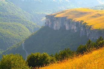
| + | The old town centre, inside the line of the line of the Aragonese defensive walls, is pleasant to stroll around. Not much of Pescara’s older architecture survived the attentions of World War II. The city is, however, only some 40 kilometres from the Parco Nazionale della Majella with its wild, mountainous landscape and rare wildlife, including wolf, bear, chamois, otter and golden eagle and is probably the best place to base yourself for a visit. | ||
| + | |||
| + | ==Friends== | ||
Contact details of "Cruiser's Friends" that can be contacted for local information or assistance. | Contact details of "Cruiser's Friends" that can be contacted for local information or assistance. | ||
* | * | ||
| - | == | + | ==Forums== |
List links to discussion threads on [[Cruising Forums|partnering forums]]. (''see link for requirements'') | List links to discussion threads on [[Cruising Forums|partnering forums]]. (''see link for requirements'') | ||
* | * | ||
| - | == | + | ==Links== |
| - | + | * {{wikipedia}} | |
| + | * {{Wikivoyage}} | ||
* | * | ||
| - | ==References | + | ==References== |
| - | ''See [[Italy#References | + | ''See [[Italy#References|Italy]]''. |
| - | + | {{Comments}} | |
| - | + | * | |
| - | * | + | |
| - | + | {{Verified by}} | |
| - | + | * May 2015 --[[User:Atheneoflymington|Athene of Lymington]] | |
| - | * | + | |
* | * | ||
| - | {{ | + | {{Page useable}} |
| - | + | ||
| - | + | ||
| - | + | ||
| - | + | ||
| - | + | ||
| - | + | ||
| - | + | ||
| - | + | ||
| - | + | ||
| - | + | ||
| - | |||
| - | |||
| - | |||
| - | |||
| - | |||
| - | |||
| + | {{Contributors|[[User:Atheneoflymington|Athene of Lymington]]}} | ||
[[Category:Ports - Italy]] | [[Category:Ports - Italy]] | ||
Latest revision as of 07:55, 21 August 2018
| Pescara Port of Entry
| |
| | |
The city of Pescara lies on the Adriatic coast of Italy around 12 miles NW of the port of Ortona and 22 miles SE of Giulianova, at the mouth of the river of the same name. The city has been substantially rebuilt and is a popular summer resort. It hosts every July an internationally famous jazz festival and also boasts one of the largest marinas along the central Adriatic coast, the Marina di Pescara with over 1000 berths, as well as further moorings for smaller yachts (mostly occupied by local vessels) at the Porto Canale in the canalised River Pescara.
Charts
- British Admiralty
- 200
- Italian
- 922
- 34
- 211
Weather
During the summer months, the prevailing winds in the Adriatic are light to moderate coastal sea breezes. In spring and autumn, northerly winds are more frequent and can quickly rise to near gale force, especially in the northern Adriatic, where the much-feared “bora” is caused by high pressure over the mountains to the NE coupled with low pressure over southern Italy. Fortunately, the fiercest “bora” is normally to be expected in the winter months. Thunderstorms are occasionally experienced in spring and especially autumn and can be accompanied by violent winds of gale force and above. Luckily they are rarely long-lasting. In the southern Adriatic, the “Scirocco”, a S/SE wind blowing up from North Africa which can last for several days, is more common. Unlike the “bora”, which can arrive without warning, a “scirocco” tends to build in strength over 24-48 hours, sometimes reaching gale force (especially in winter).
Fog is also a common problem along the coast, especially in the early morning, although it usually clears by early afternoon.
Sources for weather information:
- There is a continuous (computerized voice) weather forecast on VHF 68 - first in Italian and then followed with an English translation
- The same forecast is given in Italian and English on VHF coastal stations following a notification on channel 16
- Navtex weather forecasts covering the Adriatic are broadcast from stations at Roma, Trieste, Kerkyra (Greece) and Split (Croatia)
Passages
See Adriatic.
Islands
Communication
Add here VHF channel for the coastguard, harbor masters. etc.
Also see World Cruiser's Nets.
The town of Pescara straddles its own river and can be identified from distance by a cluster of tall aerials on the hills behind. Closer in, the buildings of the city and the long detached breakwater protecting the harbour will be seen. A tall white-painted lighthouse is also conspicuous on the S bank of the canalized entrance to the river.
To enter the Porto Canale pass either side of the detached breakwater and head for the channel between the two training walls, leaving the green buoy marking a shoal patch to starboard. The berthing areas lie around half a mile up the channel to port and starboard below the road bridge. Depths in the Porto Canale are 3.5 - 4.0 metres and along the quays 2.5 - 4.5 metres. The channel is narrow and care is needed on entry (fishing vessels tear in and out). Important note: a new pedestrian footbridge at the end of the entrance channel restricts access to yachts with a maximum air draft of 14.5 metres.
To enter the Marina di Pescara pass to the SE end of the curved breakwater that protects the marina, which will be evident from the numerous yacht masts. The marina is entered from SSE between this breakwater and a short western mole. It is important to pass down the centre of the channel bounded on the W side by a series of four orange buoys and on the E side by the marina breakwater, leaving each buoy about 10 metres to port. Depths in the channel are variable between 2.5 and 3.5 metres and if in doubt call the marina on channel 06 and a RIB will guide you in. Yachts drawing over 2.5 metres should not attempt to enter.
Note: Strong northerly winds can make entry difficult or even dangerous to both the Porto Canale and the marina.
Entrance
Pescara is a port of entry for Italy. For details see Entrance: Italy.
Personal experience checking into Pescara October 2016... we arrived from Croatia, called Marina di Pescara on the VHF radio to inform them of our arrival into the country. We had previously booked our berth & notified them of our intention to winter our boat here, so they were expecting us.
Almost as soon as we were secured into the marina berth, officials from Customs and Immigration showed up at our boat. I have no information to offer about the location of their office other than that they were very helpful and pleasant to deal with. They processed our paperwork and stamped our passports/cleared us in there at the dock. They did not board our vessel.
Shortly after that, the marina manager informed us that we needed to go to the Coast Guard office which was a few kilometers away just up the river. He actually drove us to the office, dropped us off and we walked back to the marina after we cleared in with Guardia di Finanza and the Coast Guard. The entire process from arrival at the marina to finishing up at this office took no longer than a couple of hours. --Barbjgladney 19:20, 4 June 2017 (BST)
Berthing
Porto Canale
In the Porto Canale, a small visiting yacht with suitable air draft may find a berth on the N quay, wherever there is space. Most of the N quay is reserved for concessionaires L'Ancora, Circolo Nautico Mimadea Club and Club Nautico Porto Canale and it is usually necessary to seek permission from them to take up a berth. There are electricity and water points at the club berths. The remainder of the N quay and all of the S quay are reserved for fishing boats.
- [email protected]; Tel: +39 (085) 694 040; VHF channels 12 & 16
Marinas & Yacht Clubs
Anchorages
No anchoring is permitted in the harbour.
Amenities
| Facilities | |
|---|---|
| Water | Water in the marina and Porto Canale |
| Electricity | Eelectricity in the marina and Porto Canale |
| Toilets | In the marina |
| Showers | In the marina |
| Laundry | Marina di Pescara has a fairly new onsite self-service laundry facility. The washer €4 per load, including soap. Dryer costs €1/10 minutes
--Barbjgladney 19:30, 4 June 2017 (BST) |
| Garbage | Bins at the Porto Canale and in Marina di Pescara |
| Supplies | |
| Fuel | Fuel station in the marina |
| Bottled gas | ? |
| Chandlers | In the marina |
| Services | |
| Repairs | In Porto Canale: Slipway. Mobile crane (120 T). Wooden hull repairs. Divers. For details of marina yard services, see Marina di Pescara |
| Internet | WiFi in the marina |
| Mobile connectivity | ? |
| Vehicle rentals | Numerous rental outlets in the city |
Provisioning
- Conad supermarket 15 minutes from marina, half way down Viale Amerigo Vespucci
- Vodafone, 3 and Wind mobile 'phone shops in Viale Guglielmo Marconi
Eating out
- Filippo fish restaurant half way along Viale Amerigo Vespucci (and close to Conad supermarket) is excellent value and much frequented by locals
- Guerino is my favorite fish restaurant in Pescara. Worth a trip. --Istioploos
- Several restaurants and café/bars in the marina
Transportation
- Buses to most local destinations from the city. Direct buses to Rome.
- Railway stations (three) with connections to most destinations.
- Airport (4 kms) with flights to several international destinations.
- Ferries and hydrofoils to Croatia.
Tourism
History
In antiquity Pescara was named Aternum and was an important port for trade between Rome and the eastern empire, being connected to the capital by the Via Tiburtina and Via Valeria by the time of the Emperor Claudius (49 BC). The city was subsequently a battleground between Lombards, Normans, Venetians and various adventurers until its fortification by the Aragonese in the 15th century. The city beat off a determined attack by a Turkish fleet in 1566. It was, however, very badly damaged in a later conflict, being almost flattened during world War II.
Places to Visit
The old town centre, inside the line of the line of the Aragonese defensive walls, is pleasant to stroll around. Not much of Pescara’s older architecture survived the attentions of World War II. The city is, however, only some 40 kilometres from the Parco Nazionale della Majella with its wild, mountainous landscape and rare wildlife, including wolf, bear, chamois, otter and golden eagle and is probably the best place to base yourself for a visit.
Friends
Contact details of "Cruiser's Friends" that can be contacted for local information or assistance.
Forums
List links to discussion threads on partnering forums. (see link for requirements)
Links
References
See Italy.
Comments
We welcome users' contributions to the Wiki. Please click on Comments to view other users' comments, add your own personal experiences or recommend any changes to this page following your visit.
Verified by
Date of member's last visit to Pescara and this page's details validated:
- May 2015 --Athene of Lymington
| This is a usable page of the cruising guide. However, please contribute if you can to help it grow further. Click on Comments to add your personal notes on this page or to discuss its contents. Alternatively, if you feel confident to edit the page, click on the edit tab at the top and enter your changes directly. |
| |
|---|
|
Names: Athene of Lymington |
