Poros
From CruisersWiki
m (Text replace - " <small>[''add 3 tildes (<nowiki>~~~</nowiki>) on the name line'']</small>" to "") |
|||
| Line 13: | Line 13: | ||
| [http://mapserver.mytopo.com/homepage/index.cfm?lat=37.52036818594014&lon=23.483599829372732&scale=750000&zoom=100&type=0&icon=0&width=498&height=498&searchscope=dom&CFID=17583484&CFTOKEN=79232580&scriptfile=http://mapserver.mytopo.com/homepage/index.cfm&latlontype=DMS Local chartlet] | | [http://mapserver.mytopo.com/homepage/index.cfm?lat=37.52036818594014&lon=23.483599829372732&scale=750000&zoom=100&type=0&icon=0&width=498&height=498&searchscope=dom&CFID=17583484&CFTOKEN=79232580&scriptfile=http://mapserver.mytopo.com/homepage/index.cfm&latlontype=DMS Local chartlet] | ||
|} | |} | ||
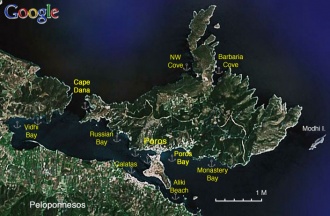
| + | [[Image:Greece_Poros_S.jpg|330px|thumb|right|Satellite View of Poros<br/>''Click for larger view'']] | ||
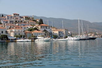
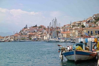
| + | [[Image: PorosTown.jpg|330px|thumb|right|Poros town from N<br/>''Click for larger view'']] | ||
| - | |||
An online cruising Guide for yachts sailing to Poros (Greek Islands) | An online cruising Guide for yachts sailing to Poros (Greek Islands) | ||
| + | [http://en.wikipedia.org/wiki/Poros '''Poros'''] (Πόρος) is a small island 26 miles S of Athens and less than a mile from the NE coast of the [http://en.wikipedia.org/wiki/Peloponnesos Peloponnese]. It is pre-eminently a vacation spot for middle class Athenians and every weekend it is bustling with activity. It is also a magnet for visiting yachtsmen in view of its sheltered situation at the E end of a large, almost landlocked bay. Its main harbour is effectively the quayed S and NW sides of the small peninsula on which the town sits and, together with the numerous anchorages around the bay, can easily accommodate several hundred yachts in secure and attractive surroundings. Winds are seldom very strong in the bay and, depending on conditions, yachts berth stern/bows-to or alongside on the long S quay or stern/bows-to the NW quay. There are water and electricity points along both quays. In addition, there are some excellent and well protected anchorages in the bay to the W of the town. | ||
| + | ==Charts== | ||
| - | + | '''BA''' 1657 Saronikós Kólpos | |
| - | + | '''Imray-Tetra''' G14 Saronic and Argolic Gulf | |
| - | + | '''NIMA''' 54344 Saronicos Kolpos & K. Petalion | |
| - | + | ||
| - | + | ||
| - | + | ||
| - | + | ||
| - | + | ||
| - | + | ||
| - | + | '''Greek''' 413 Saronikos Kolpos | |
| - | + | ||
| - | + | ||
| - | + | ||
| - | + | ||
| - | + | ||
| - | + | ||
| - | + | ||
==Radio Nets== | ==Radio Nets== | ||
| Line 48: | Line 38: | ||
==Approach and Navigation== | ==Approach and Navigation== | ||
| - | + | The approach to Poros from N passes through a fairly narrow channel with good depths, although a swell can be pushed into it in strong NE winds. In the approach from S, the small islet of Nisos Bourtzi and an even smaller islet inshore should be left to port as there are shallows inshore. The channel into Poros from this direction passes close to the N shore and depths are as little as 3.5- 4.0 metres at its shallowest part (where the charter yachts moor). There are extensive shallows extending for 250 metres off the settlement of Galatas on the S side and you will go aground if you stray too close. Beware especially the hydrofoil, which uses a quay just round the corner at the SW end of the peninsula and leaves at speed, hugging the N shore as it goes. The driver has only one rule of the road which is: get out of my way! | |
| - | + | ||
| - | + | ||
==Check-in facilities== | ==Check-in facilities== | ||
| - | None. | + | None. The Athens marinas are the nearest ports of entry to the N; Navplion in the Peloponnese to the SW and Ermoupolis on Syros to the E. |
==Ports and Popular Stops== | ==Ports and Popular Stops== | ||
===Ports=== | ===Ports=== | ||
| - | ====Poros | + | ====Poros Harbour==== |
| - | + | [[image:World_icon.png]] {{Coord|37|30.2|N|23|27.21|E|}}<br/> | |
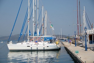
| - | + | Poros town harbour provides excellent year round shelter but, because of the constant traffic of large and small ferries, there is an almost continual wash caused by their wakes. Also, during S winds, there can be gusts. However, many yachts winter here in perfect safety. The town is built on a small peninsula surrounded by quays along the S and NW sides. On the more popular and quieter NW side, visiting yachts can berth using their anchors stern/bows-to either the quay or the long pontoon that extends out at right angles from the N end of the quay. Depths along the quay here range from 2.5 – 3.5 metres (although ballasting in a couple of spots reduces this) and on the pontoon from 3.5 metres at the inshore end to over 10.0 metres at the outer end. You will be dropping your anchor in around 10.0 metres wherever you decide to berth, so allow for lots of chain. Holding is excellent in mud. Water and electricity can be obtained on the quay but not at present on the pontoon. In either position, good fendering and a good clearance off the quay are essential in view of the heavy wash from ferries. | |
| - | + | ||
| - | + | ||
| - | + | ||
| - | + | ||
| - | + | ||
| - | + | ||
| - | + | ||
| - | + | ||
| - | + | ||
| - | + | ||
| - | + | ||
| + | On the S quay, yachts can moor using their anchors stern/bows-to the quay just W of the laid moorings of the charter fleet and local boats. Depths here are 3.0 – 4.0 metres and you will be dropping your anchor in 5.0 – 6.0 metres. Holding is excellent in mud. Alternatively, at less busy periods a limited number of yachts can lie alongside the quay immediately E of the ferry quay (being sure not to obstruct the ferries), where there are depths of 3.5 – 4.0 metres. However, the quay is very low here and there is a risk of damage if your fenders lift in a large swell. There are water and electricity points all along the quays here. | ||
| - | < | + | <font color="red">Warning:</font> Be aware of the considerable swell from the constant coming and going, at high speed, of the ferries. Leave as much distance as possible between your stern and the concrete quay. |
| - | Image: | + | [[Image:PorosNWQuay.jpg|330px|thumb|right|The NW quay looking WSW<br/>''Click for larger view'']] |
| - | Image:Poros.jpeg|The | + | [[Image: Poros.jpeg|330px|thumb|right|The S quay looking NW<br/>''Click for larger view'']] |
| - | </ | + | [[Image: PorosPontoon.jpg|330px|thumb|right|The pontoon looking NW<br/>''Click for larger view'']] |
===Anchorages=== | ===Anchorages=== | ||
====Russian Bay==== | ====Russian Bay==== | ||
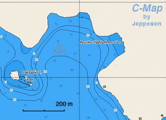
| - | [[Image:Greece_Poros_Russian_h.jpg| | + | [[Image:Greece_Poros_Russian_h.jpg|330px|thumb|right|Chart of Russian Bay<br/>''Click for larger view'']] |
[[image:World_icon.png]] {{Coord|37|31.1|N|23|25.96|E|}}<br/> | [[image:World_icon.png]] {{Coord|37|31.1|N|23|25.96|E|}}<br/> | ||
| - | Russian Bay or Daskalia bay is a | + | Russian Bay or Daskalia bay is a well protected bay just 1.4 miles W of Poros. In the entrance of the bay is the tiny Daskalia island with a chapel. Anchor in about 6.0 metres wherever there is space. The bottom is sand and weed, good holding once through the weed. If the wind is variable or the anchorage is busy, it best to take a shore line to one of the rocks. The bay was named Russian because in the last century there was a Russian naval base here. The ruins of their storage facilities, ashore, can still be seen. Although a very pleasant anchorage, the water is murky and one’s peace is disturbed by the frequent wash from the ferries. Poros town is an hour and a quarter on foot, but quicker by dinghy. |
| - | + | ====Neorion Bay==== | |
| + | [[image:World_icon.png]] {{Coord|37|30.9|N|23|25.98|E|}}<br/> | ||
| + | Neorion Bay is situated a mile NW of Poros town. It is an attractive, tree-lined bay with a few small villa complexes, a couple of tavernas and a water sports centre. Although noisier than some of the other anchorages, its leafiness makes it one of the prettiest. Anchor in 6.0 – 8.0 metres around 50 metres off the shore. The holding is good in mud and weed once through the weed (you may need more than one attempt). Like all the Poros bay anchorages, one’s peace is occasionally disturbed by the frequent wash from the ferries. | ||
====Vidhi Bay==== | ====Vidhi Bay==== | ||
[[image:World_icon.png]] {{Coord|37|30.92|N|23|23.76|E|}}<br/> | [[image:World_icon.png]] {{Coord|37|30.92|N|23|23.76|E|}}<br/> | ||
| - | This protected and shallow bay is on the [http://en.wikipedia.org/wiki/Peloponnesos Peloponnese] | + | This protected and shallow bay is on the [http://en.wikipedia.org/wiki/Peloponnesos Peloponnese] at the W end of the bay of Poros. It offers good shelter except with strong E winds. Anchor in 5.0 – 6.0 metres in the bay or one of the coves on its N side. Holding is good in mud and weed. |
====Galatas==== | ====Galatas==== | ||
[[image:World_icon.png]] {{Coord|37|29.94|N|23|26.8|E|}}<br/> | [[image:World_icon.png]] {{Coord|37|29.94|N|23|26.8|E|}}<br/> | ||
| - | + | The village of Galatas is opposite the S quay of Poros town on the [http://en.wikipedia.org/wiki/Peloponnesos Peloponnese]. The waters along the shore here are very shallow and yachts seldom anchor here. Where there are suitable depths, private moorings have been laid and no anchoring is possible. | |
====Poros Bay==== | ====Poros Bay==== | ||
[[image:World_icon.png]] {{Coord|37|30.4|N|23|28|E|}}<br/> | [[image:World_icon.png]] {{Coord|37|30.4|N|23|28|E|}}<br/> | ||
| - | The bay just E of the town. | + | The bay just E of the town. Depths here are over 10 metres until very close inshore and the holding is poor. It is usually used as a day anchorage only. |
====Aliki Beach==== | ====Aliki Beach==== | ||
[[image:World_icon.png]] {{Coord|37|29.4|N|23|28.1|E|}}<br/> | [[image:World_icon.png]] {{Coord|37|29.4|N|23|28.1|E|}}<br/> | ||
| - | + | Aliki Beach lies due S of the small islet of Nisos Bourtzi in the S entrance to Poros bay on the Peloponnese side. It is relatively shallow but the bottom is sand and good holding. Shelter is only moderate and it is best considered as a day anchorage only. | |
====Monastery Bay==== | ====Monastery Bay==== | ||
[[image:World_icon.png]] {{Coord|37|30.3|N|23|28.8|E|}}<br/> | [[image:World_icon.png]] {{Coord|37|30.3|N|23|28.8|E|}}<br/> | ||
| - | + | Monastery Bay lies about one mile E from the town, under the Monastery of Zoodochos Pigi. It is very deep and provides poor holding, suitable only for a brief stop. Stay with the boat as she may drag. | |
====Barbaria Cove==== | ====Barbaria Cove==== | ||
| Line 110: | Line 90: | ||
Barbaria cove is on the N side of the island. It is a land locked and well protected cove, with only a couple of houses ashore. Good holding. | Barbaria cove is on the N side of the island. It is a land locked and well protected cove, with only a couple of houses ashore. Good holding. | ||
| - | ==== | + | ====Yerolimena==== |
| - | + | ||
| - | + | ||
| - | + | ||
| - | + | ||
[[image:World_icon.png]] {{Coord|37|31.4|N|23|25.6|E|}}<br/> | [[image:World_icon.png]] {{Coord|37|31.4|N|23|25.6|E|}}<br/> | ||
| - | + | Yerolimena is a small cove is at the westernmost end of the island, 500 metres S of Cape Dana at the N end of the entrance channel into Poros bay. It offers excellent shelter from all directions in very peaceful and attractive surroundings. It also has probably the clearest water of any of the Poros bay anchorages. Anchor in 4.0 – 5.0 metres wherever there is space. The holding is good in sand and weed. At busy times, it may be advisable to take a line ashore to stop yourself swinging. | |
==Marinas & Yacht Clubs== | ==Marinas & Yacht Clubs== | ||
| Line 130: | Line 106: | ||
====Fuel, Water, & Electricity==== | ====Fuel, Water, & Electricity==== | ||
; Fuel | ; Fuel | ||
| - | : Diesel fuel is delivered by a mini-tanker. For a delivery hail Mr. Eliades on | + | : Diesel fuel is delivered by a mini-tanker. For a delivery hail Mr. Eliades on VHF Channel 77. |
; Water | ; Water | ||
| - | : On the quay | + | : On the quay (connected for a fee by the water man) |
; Electricity | ; Electricity | ||
| - | : | + | : On the quay (prepaid card system) |
==Offshore Islands== | ==Offshore Islands== | ||
| Line 141: | Line 117: | ||
==Tourism and Things to do Ashore== | ==Tourism and Things to do Ashore== | ||
===Tourism=== | ===Tourism=== | ||
| - | The | + | The whole bay of Poros is in a delightful setting, its shores lined with pine and cypress trees, and the entry to it by yacht is one of the most beautiful in Greece. The town is similarly very picturesque and pleasant with many tavernas, bars and small provisions stores. While it is very busy and tourist-thronged down at the quayside, a steep climb up to the main town square around the cathedral is rewarded with superb views and comparative peace and quiet. For the energetic (or with transport), a five km walk or drive E from the town and a further 40 minute climb brings you to the [http://www.maicar.com/GML/Poseidon.html Poseidon] Sanctuary. This is the place that [http://en.wikipedia.org/wiki/Demosthenes Demosthenes] committed suicide in 322 BC. The Sanctuary is dated from the 6th century BC. The Monastery of Zoodochos Pigi is about 35 km from the town in a heavily wooded location. It has a post Byzantine woodcarved iconostasis. History buffs will recall that Poros was the place where the reconstructed [http://www.atm.ox.ac.uk/rowing/trireme/ Athenian Trireme] was tested. This was a joint project between a team of British Classicists and naval architects and was funded by the Greek Navy. The objective was to find out the speed and fighting abilities of these remarkable ancient ships. |
| - | + | ||
| - | + | ||
===Grocery & Supply Stores=== | ===Grocery & Supply Stores=== | ||
| - | There are | + | There are numerous provisions shops in the town, especially along the NW quay, where there is a good butcher, small supermarket and a bakery. |
===Eateries=== | ===Eateries=== | ||
| - | There are | + | There are numerous restaurants along the S quay and better ones up in the town. |
| + | * O Kipas (The Garden) near the cathedral up in the old town is a personal favourite --[[User:Atheneoflymington|Athene of Lymington]] 15:30, 11 September 2011 (BST) | ||
===Internet/WiFi=== | ===Internet/WiFi=== | ||
| - | + | Via a free municipal wifi (Poros Wifi) or in Internet cafés. | |
===Laundry=== | ===Laundry=== | ||
| Line 158: | Line 133: | ||
===Motorbike & Car Rentals=== | ===Motorbike & Car Rentals=== | ||
| - | You can rent either motorbikes or bicycles. | + | You can rent either motorbikes or bicycles from several outlets. |
===Garbage Disposal=== | ===Garbage Disposal=== | ||
| - | There are bins around the | + | There are bins around the harbour and in some of the anchorages. |
===Transportation=== | ===Transportation=== | ||
| Line 176: | Line 151: | ||
* | * | ||
* | * | ||
| - | |||
| - | |||
==External Links== | ==External Links== | ||
* [http://en.wikipedia.org/wiki/Poros Poros] (Wikipedia) | * [http://en.wikipedia.org/wiki/Poros Poros] (Wikipedia) | ||
* | * | ||
| - | |||
| - | |||
==References & Publications== | ==References & Publications== | ||
See [[Greece#References_&_Publications|Greece]]. | See [[Greece#References_&_Publications|Greece]]. | ||
| Line 190: | Line 161: | ||
''Date of member's visit to this marina & this page's details validated'': | ''Date of member's visit to this marina & this page's details validated'': | ||
* September 2001 --[[User:Istioploos|Istioploos]] [[Image:Greece_Icon.png]] | * September 2001 --[[User:Istioploos|Istioploos]] [[Image:Greece_Icon.png]] | ||
| - | * | + | * September 2011 --[[User:Atheneoflymington|Athene of Lymington]] 15:30, 11 September 2011 (BST) |
| Line 205: | Line 176: | ||
|- | |- | ||
|style="color:#000;"|<small> | |style="color:#000;"|<small> | ||
| - | '''Names''': | + | '''Names''': --[[User:Atheneoflymington|Athene of Lymington]] 15:30, 11 September 2011 (BST) |
</small> | </small> | ||
|} | |} | ||
Revision as of 14:30, 11 September 2011
Poros (Greek Islands)
| | |
| | 37°30′N, 23°27′E |
|---|---|
| | Photo gallery |
| | Local chartlet |
An online cruising Guide for yachts sailing to Poros (Greek Islands) Poros (Πόρος) is a small island 26 miles S of Athens and less than a mile from the NE coast of the Peloponnese. It is pre-eminently a vacation spot for middle class Athenians and every weekend it is bustling with activity. It is also a magnet for visiting yachtsmen in view of its sheltered situation at the E end of a large, almost landlocked bay. Its main harbour is effectively the quayed S and NW sides of the small peninsula on which the town sits and, together with the numerous anchorages around the bay, can easily accommodate several hundred yachts in secure and attractive surroundings. Winds are seldom very strong in the bay and, depending on conditions, yachts berth stern/bows-to or alongside on the long S quay or stern/bows-to the NW quay. There are water and electricity points along both quays. In addition, there are some excellent and well protected anchorages in the bay to the W of the town.
Charts
BA 1657 Saronikós Kólpos
Imray-Tetra G14 Saronic and Argolic Gulf
NIMA 54344 Saronicos Kolpos & K. Petalion
Greek 413 Saronikos Kolpos
Radio Nets
Also see World Cruiser's Nets
- Coast Guard - VHF channel 12
- Weather - VHF channel 86
- Olympia Radio - VHF channels 27, 28, and 88
Weather
See Aegean Sea.
The approach to Poros from N passes through a fairly narrow channel with good depths, although a swell can be pushed into it in strong NE winds. In the approach from S, the small islet of Nisos Bourtzi and an even smaller islet inshore should be left to port as there are shallows inshore. The channel into Poros from this direction passes close to the N shore and depths are as little as 3.5- 4.0 metres at its shallowest part (where the charter yachts moor). There are extensive shallows extending for 250 metres off the settlement of Galatas on the S side and you will go aground if you stray too close. Beware especially the hydrofoil, which uses a quay just round the corner at the SW end of the peninsula and leaves at speed, hugging the N shore as it goes. The driver has only one rule of the road which is: get out of my way!
Check-in facilities
None. The Athens marinas are the nearest ports of entry to the N; Navplion in the Peloponnese to the SW and Ermoupolis on Syros to the E.
Ports and Popular Stops
Ports
Poros Harbour
![]() 37°30.2′N, 23°27.21′E
37°30.2′N, 23°27.21′E
Poros town harbour provides excellent year round shelter but, because of the constant traffic of large and small ferries, there is an almost continual wash caused by their wakes. Also, during S winds, there can be gusts. However, many yachts winter here in perfect safety. The town is built on a small peninsula surrounded by quays along the S and NW sides. On the more popular and quieter NW side, visiting yachts can berth using their anchors stern/bows-to either the quay or the long pontoon that extends out at right angles from the N end of the quay. Depths along the quay here range from 2.5 – 3.5 metres (although ballasting in a couple of spots reduces this) and on the pontoon from 3.5 metres at the inshore end to over 10.0 metres at the outer end. You will be dropping your anchor in around 10.0 metres wherever you decide to berth, so allow for lots of chain. Holding is excellent in mud. Water and electricity can be obtained on the quay but not at present on the pontoon. In either position, good fendering and a good clearance off the quay are essential in view of the heavy wash from ferries.
On the S quay, yachts can moor using their anchors stern/bows-to the quay just W of the laid moorings of the charter fleet and local boats. Depths here are 3.0 – 4.0 metres and you will be dropping your anchor in 5.0 – 6.0 metres. Holding is excellent in mud. Alternatively, at less busy periods a limited number of yachts can lie alongside the quay immediately E of the ferry quay (being sure not to obstruct the ferries), where there are depths of 3.5 – 4.0 metres. However, the quay is very low here and there is a risk of damage if your fenders lift in a large swell. There are water and electricity points all along the quays here.
Warning: Be aware of the considerable swell from the constant coming and going, at high speed, of the ferries. Leave as much distance as possible between your stern and the concrete quay.
Anchorages
Russian Bay
![]() 37°31.1′N, 23°25.96′E
37°31.1′N, 23°25.96′E
Russian Bay or Daskalia bay is a well protected bay just 1.4 miles W of Poros. In the entrance of the bay is the tiny Daskalia island with a chapel. Anchor in about 6.0 metres wherever there is space. The bottom is sand and weed, good holding once through the weed. If the wind is variable or the anchorage is busy, it best to take a shore line to one of the rocks. The bay was named Russian because in the last century there was a Russian naval base here. The ruins of their storage facilities, ashore, can still be seen. Although a very pleasant anchorage, the water is murky and one’s peace is disturbed by the frequent wash from the ferries. Poros town is an hour and a quarter on foot, but quicker by dinghy.
Neorion Bay
![]() 37°30.9′N, 23°25.98′E
37°30.9′N, 23°25.98′E
Neorion Bay is situated a mile NW of Poros town. It is an attractive, tree-lined bay with a few small villa complexes, a couple of tavernas and a water sports centre. Although noisier than some of the other anchorages, its leafiness makes it one of the prettiest. Anchor in 6.0 – 8.0 metres around 50 metres off the shore. The holding is good in mud and weed once through the weed (you may need more than one attempt). Like all the Poros bay anchorages, one’s peace is occasionally disturbed by the frequent wash from the ferries.
Vidhi Bay
![]() 37°30.92′N, 23°23.76′E
37°30.92′N, 23°23.76′E
This protected and shallow bay is on the Peloponnese at the W end of the bay of Poros. It offers good shelter except with strong E winds. Anchor in 5.0 – 6.0 metres in the bay or one of the coves on its N side. Holding is good in mud and weed.
Galatas
![]() 37°29.94′N, 23°26.8′E
37°29.94′N, 23°26.8′E
The village of Galatas is opposite the S quay of Poros town on the Peloponnese. The waters along the shore here are very shallow and yachts seldom anchor here. Where there are suitable depths, private moorings have been laid and no anchoring is possible.
Poros Bay
![]() 37°30.4′N, 23°28′E
37°30.4′N, 23°28′E
The bay just E of the town. Depths here are over 10 metres until very close inshore and the holding is poor. It is usually used as a day anchorage only.
Aliki Beach
![]() 37°29.4′N, 23°28.1′E
37°29.4′N, 23°28.1′E
Aliki Beach lies due S of the small islet of Nisos Bourtzi in the S entrance to Poros bay on the Peloponnese side. It is relatively shallow but the bottom is sand and good holding. Shelter is only moderate and it is best considered as a day anchorage only.
Monastery Bay
![]() 37°30.3′N, 23°28.8′E
37°30.3′N, 23°28.8′E
Monastery Bay lies about one mile E from the town, under the Monastery of Zoodochos Pigi. It is very deep and provides poor holding, suitable only for a brief stop. Stay with the boat as she may drag.
Barbaria Cove
![]() 37°31.9′N, 23°29.05′E
37°31.9′N, 23°29.05′E
Barbaria cove is on the N side of the island. It is a land locked and well protected cove, with only a couple of houses ashore. Good holding.
Yerolimena
![]() 37°31.4′N, 23°25.6′E
37°31.4′N, 23°25.6′E
Yerolimena is a small cove is at the westernmost end of the island, 500 metres S of Cape Dana at the N end of the entrance channel into Poros bay. It offers excellent shelter from all directions in very peaceful and attractive surroundings. It also has probably the clearest water of any of the Poros bay anchorages. Anchor in 4.0 – 5.0 metres wherever there is space. The holding is good in sand and weed. At busy times, it may be advisable to take a line ashore to stop yourself swinging.
Marinas & Yacht Clubs
None.
Yacht Services and Repairs
Marine Stores
There is one chandler on the main square across from the ferry boat landing.
Yacht Services/Repairs/Yards
Only minor, ask at the chandlery store.
Fuel, Water, & Electricity
- Fuel
- Diesel fuel is delivered by a mini-tanker. For a delivery hail Mr. Eliades on VHF Channel 77.
- Water
- On the quay (connected for a fee by the water man)
- Electricity
- On the quay (prepaid card system)
Offshore Islands
None.
Tourism and Things to do Ashore
Tourism
The whole bay of Poros is in a delightful setting, its shores lined with pine and cypress trees, and the entry to it by yacht is one of the most beautiful in Greece. The town is similarly very picturesque and pleasant with many tavernas, bars and small provisions stores. While it is very busy and tourist-thronged down at the quayside, a steep climb up to the main town square around the cathedral is rewarded with superb views and comparative peace and quiet. For the energetic (or with transport), a five km walk or drive E from the town and a further 40 minute climb brings you to the Poseidon Sanctuary. This is the place that Demosthenes committed suicide in 322 BC. The Sanctuary is dated from the 6th century BC. The Monastery of Zoodochos Pigi is about 35 km from the town in a heavily wooded location. It has a post Byzantine woodcarved iconostasis. History buffs will recall that Poros was the place where the reconstructed Athenian Trireme was tested. This was a joint project between a team of British Classicists and naval architects and was funded by the Greek Navy. The objective was to find out the speed and fighting abilities of these remarkable ancient ships.
Grocery & Supply Stores
There are numerous provisions shops in the town, especially along the NW quay, where there is a good butcher, small supermarket and a bakery.
Eateries
There are numerous restaurants along the S quay and better ones up in the town.
- O Kipas (The Garden) near the cathedral up in the old town is a personal favourite --Athene of Lymington 15:30, 11 September 2011 (BST)
Internet/WiFi
Via a free municipal wifi (Poros Wifi) or in Internet cafés.
Laundry
There is a laundry next to the telephone office (OTE).
Motorbike & Car Rentals
You can rent either motorbikes or bicycles from several outlets.
Garbage Disposal
There are bins around the harbour and in some of the anchorages.
Transportation
Very frequent transportation to Athens from the Flying Dolphins (hydrofoils).
Routes/Passages To/From
Cruiser's Friends
Contact details of "Cruiser's Friends" that can be contacted for local information or assistance.
Forum Discussions
List links to discussion threads on partnering forums. (see link for requirements)
External Links
- Poros (Wikipedia)
References & Publications
See Greece.
Last Visited & Details Checked (and updated here)
Date of member's visit to this marina & this page's details validated:
- September 2001 --Istioploos

- September 2011 --Athene of Lymington 15:30, 11 September 2011 (BST)
Personal Notes
Personal experiences?
|
|---|
|
Names: --Athene of Lymington 15:30, 11 September 2011 (BST) |
| |
|---|
| | HOMEPAGE | Wiki Contents | Mediterranean | Aegean Sea | Greece | Poros | |
.
