Port Lakka
From CruisersWiki
m (→Tourism) |
m (→Personal Notes) |
||
| Line 145: | Line 145: | ||
==Personal Notes== | ==Personal Notes== | ||
Personal experiences? | Personal experiences? | ||
| - | * Anchoring with a line ashore on the NW side of the bay is best if you want to be a little out of the anchoring hurly-burly and of the regular swell in fresh NW winds. | + | * Anchoring with a line ashore on the NW side of the bay is best if you want to be a little out of the anchoring hurly-burly and of the regular swell in fresh NW winds. --[[User:Atheneoflymington|Athene of Lymington]] 07:44, 17 September 2012 (BST) |
==Last Visited & Details Checked (and updated here)== | ==Last Visited & Details Checked (and updated here)== | ||
Revision as of 06:44, 17 September 2012
Port Lakka, Paxos
| | |
| | 39°14.64′N, 20°07.75′E |
|---|---|
| | Photo gallery |
| | Chartlet |
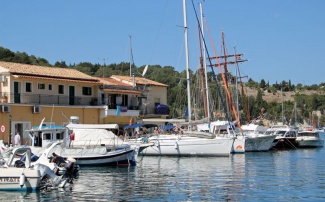
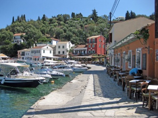
The harbour and anchorage of Port Lakka lies at the NE tip of the island of Paxos in the Ionian Sea of Greece. It consists of a large natural inlet protected from all winds except NE, with the small town of Lakka and its town quay at its head on the SE side. It is a very popular anchorage with yachts on transit down from Corfu to Lefkas and back and consequently gets very busy during the peak season. The town ashore is totally dedicated to serving the needs of tourists and virtually every house is a taverna, café, boutique or souvenir shop. Mooring options here include anchor mooring to the town quay, free anchoring in the bay if room permits or anchoring with a long line ashore on the N side of the inlet. Shelter is good in most conditions, although strong N winds send in a swell and, if the winds turn NE (which is fortunately rare), they blow directly down into the inlet.
Charts
- BA
- 189 Nisos Sapiénza to Nisos Paxoi
- 203 Zakinthos to Paxoi
- Imray-Tetra
- G11 Nísos Kérkira to Nísos Levkas
- NIMA
- 54280 Corfu Channel to Nisis Proti
- Greek
- 212 Othonoi I. to Amvrakikos Gulf- Kerkyra I. And Paxoi I. Inset: Northern Kerkyra Strait
Radio Nets
Also see Cruiser's Nets
- Coast Guard - VHF channel 12
Local Weather
- See Ionian Sea Weather
- Also see Ionian Sea Currents & Tides
There are no dangers in the approach from N, although Vrak Marmaro, the rocky islet and reef just NW of the inlet, should be given a wide berth. Approaching from S, the principal danger is the reef of Ifalos Paxoi about half a mile off the small harbour of Longos two miles SW of Port Lakka. From this direction, it is difficult to identify the inlet until almost past it.
Depths in the entrance channel are mostly between 6.0 and 8.0 metres and in the rest of the inlet range from 3.0 - 4.0 metres in the anchorage to just under 6.0 metres in a patch 100 metres off the town quay.
Check-in facilities
The nearest port of entry is Port Gaios.
Offshore Islands and Groups
Berthing options
TOWN QUAY
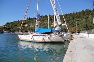
The town quays in Port Lakka consist of a main stretch directly facing the anchorage, which can accommodate around a dozen yachts, a short quay on the E side, where no more than 2-3 yachts can squeeze in, and a shallow quay continuing E and N from the main quay, where there is room for 3-4 yachts moored bows-to in view of the shallow depths.
Click on this link for a map of the berthing options in Port Lakka: [1]. The illustration shows the various berthing options as A: Main town quay; B: E side quay: C: Shallow E quay.
A: Main town quay
This section of the quay, facing the anchorage, runs for around 100 metres from the small ferry ramp at its E end as far as the small craft moorings that then continue as far as a tiny inlet crammed with day fishing boats at its W end. The quay can accommodate around 10-12 yachts anchor moored stern or bows-to in depths of 2.0 – 2.5 metres at the quay (the deeper water being at the E end). Depths further out, where yachts drop anchor, are nearer 4.0 – 5.0 metres. The holding here is good in sand and weed – once through the weed.
B. E side quay
This section of the quay is ‘round the corner’ from the ferry ramp and there is just enough space for 2-3 yachts to anchor moor (preferably bows-to, since the depths are irregular and mostly little more than 1.5 metres). You need to be careful not to lay your anchor across the chains of any boats moored on the Shallow E quay.
C. Shallow E quay
This section begins at the inner corner of the E side quay, which is very shallow and filled with rubble, and extends E and N for around 100 metres. Most of it is shallow and occupied by local small craft, but a short section starting around 20 metres from the corner can be used with care by yachts anchored bows-to. There is room for 3/4 yachts moored in this way, but note that the depths are just 1.25 metres, shallowing towards the corner. You need to be careful not to lay your anchor across the chains of any boats moored on the E side quay.
Anchorages
The anchorage is large and depths throughout are suitable for all but the deepest draft yachts to anchor. It is invariably very busy here and late arrivals may have to position their anchors with care to avoid interfering with other boats. Otherwise, anchor wherever there is space, either in the sandy area to the N of the inlet, where depths are 3.0 – 4.0 metres and holding is good, or on the weedy part towards the S of the inlet, where depths of nearly 6.0 metres can be found in places (but it may require more than one attempt to dig your anchor in). It should not be necessary to lie to any more than 20-25 meters of chain (even if you initially lay out more to dig in), as your swinging circle is more likely to cause interference with other boats if you do.
If arriving late, or merely if you prefer, anchor and take a line ashore on the NW side of the inlet. This position has the advantage of being out of the worst of any swell that may enter with fresh to strong NW winds.
Marinas & Yacht Clubs
None.
Yacht Repairs and Services
None.
Boat Yards
None.
Fuel, Water, & Electricity
- Fuel
- None
- Water
- A long water hose can be used to refill tanks. It is coiled on a wall at the W end of the town quay.
- Electricity
- There is a single stanchion at the W end of the quay with four electricity points. Enquire at the nearest café for a prepaid key needed to use it.
Things to do Ashore
Tourism
The town of Lakka is in an attractive setting and its narrow streets mean that it is virtually traffic-free. However, these days it is basically a tourist village, with virtually every house tendering to the needs of land and water-based tourists. There are some good walks around the inlet out to the headland on the N side and a good beach around the headland to the SE. A longer walk SE brings you to the tiny port and village of Longos, which is even smaller and more picturesque than Lakka itself. By boat, there are several large sea caves eroded into the cliffs on the W side of the island which can be visited in suitable conditions.
Grocery & Supply Stores
- Two small supermarkets, a butcher and two bakeries in the town.
Eateries
- Several bars, cafes and tavernas near the town quay, and more in the streets behind.
Internet/WiFi
- Several bars and cafes along the quay offer wi-fi.
Laundry
- None.
Motorbike & Car Rentals
- None.
Garbage Disposal
Bins close to the town quay.
Transportation
- Ferry to Parga on the mainland.
Useful Contacts
Routes/Passages To/From
Popular passages/routes, timing, etc.
Cruiser's Friends
Contact details of "Cruiser's Friends" that can be contacted for local information or assistance.
Forum Discussions
List links to discussion threads on partnering forums. (see link for requirements)
External links
References & Publications
See Ionian Sea.
Personal Notes
Personal experiences?
- Anchoring with a line ashore on the NW side of the bay is best if you want to be a little out of the anchoring hurly-burly and of the regular swell in fresh NW winds. --Athene of Lymington 07:44, 17 September 2012 (BST)
Last Visited & Details Checked (and updated here)
Date of member's visit to this Port/Stop & this page's details validated:
- September 2012 --Athene of Lymington 20:06, 16 September 2012 (BST)
|
|---|
|
Names: Istioploos, Athene of Lymington |
| |
|---|
| | HOMEPAGE | Wiki Contents | Mediterranean | Ionian Sea | Greece | Paxos | Port Lakka |


