Senj
From CruisersWiki
Istioploos (Talk | contribs) (Template) |
|||
| (36 intermediate revisions not shown) | |||
| Line 1: | Line 1: | ||
| - | + | {{IsPartOf|Mediterranean|Adriatic Sea|Croatia|Kvarner Gulf}} | |
| - | {| | + | {{TOC block}} |
| - | | | + | |
| - | | | + | |
| - | + | ||
| - | + | ||
| - | + | ||
| - | + | ||
| - | + | ||
| - | + | ||
| - | + | ||
| - | + | ||
| - | + | ||
| - | + | ||
| - | + | ||
| - | + | ||
| - | + | ||
| - | + | ||
| - | + | ||
| - | + | ||
| - | + | {{Infobox | |
| + | | lat= 44.991|lon=14.898 | ||
| + | | name= Senj | ||
| + | | portofentry= y | ||
| + | | zoom= 15 | ||
| + | | chartlet = y | ||
| + | | image= Senj.jpg | ||
| + | | imagetext= Senj harbour from W | ||
| + | | summary= The harbour of '''Senj''' lies on the mainland coast of [[Croatia]] in the Vinodolska channel, opposite the SE end of the island of [[Krk]] and close to the point where the Vinodolska channel becomes the Velebitski channel. The town itself is ancient, dating back well before the Roman period, and well worth visiting. The harbour, however, does not offer good shelter and is a place to be avoided if there is any risk of a ''bora'' or, indeed, any fresh to strong winds from N round to SW. In settled weather, however, it is a fascinating place to visit and little frequented by cruising yachts. | ||
| + | | notes= | ||
| + | | news= | ||
| + | }} | ||
| - | + | ==Charts== | |
| - | + | ''See [[Kvarner Gulf#Charts|Kvarner Gulf]]''. | |
| - | + | ||
| - | + | ==Weather== | |
| + | ''See [[Croatia#Weather|Croatia]]''. | ||
| - | == | + | ==Passages== |
| - | + | ''See [[Croatia#Passages|Croatia]]''. | |
| - | == | + | ==Islands== |
| - | + | * [[Krk]] | |
| - | === | + | ==Communication== |
| - | + | {{Green|Add here VHF channel for the coastguard, harbor masters. etc.}} | |
| + | * | ||
| + | * | ||
| + | |||
| + | ''Also see [[HF_Radio|Cruiser's Nets]]'' | ||
| + | |||
| + | ==Navigation== | ||
| + | '''Senj''' is approached either via the Vinodolska channel leading under the road bridge linking the island of [[Krk]] to the mainland, which has a clearance of over 50 metres, or through the narrow channel between the S end of [[Krk]] and the small island of Prvic. The harbour lies on the N side of a headland dominated by a conspicuous 16th century castle and consists of a small bay partly protected on the N side by a short breakwater. | ||
| - | + | Depths in the entrance are 6.0 metres and at the quays 3.0 - 5.0 metres. Shelter is reasonable in moderate winds from NE round to S but poor in all other conditions. The harbour is untenable in strong winds from N round to SW. | |
| - | + | ||
| - | == | + | ==Entrance== |
| - | + | [[{{PAGENAME}}]] is a port of entry/exit for Croatia. For details ''see [[Croatia#Entrance|Entrance: Croatia]]''. | |
| - | === | + | ==Berthing== |
| - | + | {{poi | lat= 44.99032|lon=14.89887 | |
| + | | type= marina | ||
| + | | name= Senj Harbour | ||
| + | | altname= | ||
| + | | url = | ||
| + | | zoom= 16 | ||
| + | | portofentry= y | ||
| + | | image= SenjHarbour.jpg | ||
| + | | imagetext= Senj harbour from SW | ||
| + | | text= Visiting yachts can moor alongside the outer part of the breakwater, avoiding the inner end of the breakwater where the ferries berth, alongside the short jetty at the SE side of the harbour or wherever there is space on the quays. Least depth on the quays is 3.0 metres and along the breakwater 5.0 metres. | ||
| + | }} | ||
===Marinas & Yacht Clubs=== | ===Marinas & Yacht Clubs=== | ||
| - | + | None. | |
| - | + | ||
| - | + | ||
| - | + | ||
| - | + | ==Anchorages== | |
| - | + | There is no suitable sheltered anchorage off Senj. | |
| - | + | ||
| - | + | ||
| - | + | ||
| - | == | + | ==Amenities== |
| - | + | {{tlist | |
| - | === | + | |header|Facilities |
| - | + | ||
| - | + | |Water| N/A (Not Available) | |
| + | |Electricity| N/A | ||
| + | |Toilets| N/A | ||
| + | |Showers| N/A | ||
| + | |Laundry| N/A | ||
| + | |Garbage| Bins around the harbour | ||
| + | |||
| + | |header|Supplies | ||
| + | |Fuel| Fuel from garage on the main road | ||
| + | |Bottled gas| {{MagentaText|?}} | ||
| + | |Chandlers| None | ||
| + | |||
| + | |header|Services | ||
| + | |Repairs| N/A | ||
| + | |Internet| N/A | ||
| + | |Mobile connectivity| {{MagentaText|?}} | ||
| + | |Vehicle rentals| N/A | ||
| + | }} | ||
| + | |||
| + | ==Provisioning== | ||
| + | Supermarkets and other provisions shops in the town. | ||
| + | |||
| + | ==Eating out== | ||
| + | Numerous bars and restaurants in the town. | ||
| + | |||
| + | ==Transportation== | ||
| + | * Buses to [[Rijeka]] and [[Krk]]. | ||
| + | * Ferry service to [[Krk]] | ||
| + | * Domestic and international trains from [[Rijeka]] to Zagreb, [[Trieste]], Ljubljana, Vienna, Munich and Salzburg. | ||
| + | |||
| + | ==Tourism== | ||
| + | ====History==== | ||
| + | {{Green|Give a short history of the port.}} | ||
| + | |||
| + | ====Places to Visit==== | ||
| + | {{Image right|SenjCastle.jpg |Nehaj fortress, Senj }} | ||
| + | {{Image right|SenjSundial.jpg |Sundial on 45th parallel, Senj }} | ||
| + | The main attraction of the town is the well-restored 16th century Nehaj castle on the promontory overlooking the bay, which was built to repel the Ottoman invaders around 1558. Another, more unusual, attraction is the sundial erected on the 45th parallel which runs through the town, marking the exact halfway point between the North Pole and the Equator. | ||
| + | |||
| + | ==Friends== | ||
| + | Contact details of "Cruiser's Friends" that can be contacted for local information or assistance. | ||
* | * | ||
| - | == | + | ==Forums== |
| - | List | + | List links to discussion threads on [[Cruising Forums|partnering forums]]. (''see link for requirements'') |
* | * | ||
* | * | ||
| - | == | + | ==Links== |
| - | + | * {{wikipedia}} | |
| + | * {{Wikivoyage}} | ||
| + | * [http://www.noonsite.com/Countries/Croatia/Senj Noonsite] | ||
* | * | ||
| - | |||
| - | |||
| - | + | ''For other useful websites, see [[Croatia#Links|Croatia]]''. | |
| - | + | ||
| - | == | + | ==References== |
| - | + | ''See [[Croatia#References|Croatia]]''. | |
| - | + | ||
| + | {{Comments}} | ||
* | * | ||
* | * | ||
| - | + | {{Verified by}} | |
| - | + | * Data compiled from web research (please update if possible)--[[User:Atheneoflymington|Athene of Lymington]] 13:14, 21 July 2011 (BST) | |
| - | + | ||
| - | * | + | |
* | * | ||
| - | |||
| - | |||
| + | {{Green|If you provide a lot of info and this page is almost complete, change <nowiki>{{Page outline}} to {{Page useable}}</nowiki>.}} | ||
| + | |||
| + | {{Page outline}} | ||
| - | |||
| + | {{Contributors|[[User:Lighthouse|Lighthouse]], [[User:Atheneoflymington|Athene of Lymington]]}} | ||
| - | |||
| - | |||
| - | |||
| - | |||
| - | |||
| - | |||
| - | |||
| - | |||
| - | |||
| - | |||
| - | |||
| - | |||
| - | |||
| - | |||
| - | |||
[[Category:Ports - Croatia]] | [[Category:Ports - Croatia]] | ||
Latest revision as of 23:30, 2 March 2019
| Senj Port of Entry
| |
| |
 Senj harbour from W |
The harbour of Senj lies on the mainland coast of Croatia in the Vinodolska channel, opposite the SE end of the island of Krk and close to the point where the Vinodolska channel becomes the Velebitski channel. The town itself is ancient, dating back well before the Roman period, and well worth visiting. The harbour, however, does not offer good shelter and is a place to be avoided if there is any risk of a bora or, indeed, any fresh to strong winds from N round to SW. In settled weather, however, it is a fascinating place to visit and little frequented by cruising yachts.
Charts
See Kvarner Gulf.
Weather
See Croatia.
Passages
See Croatia.
Islands
Communication
Add here VHF channel for the coastguard, harbor masters. etc.
Also see Cruiser's Nets
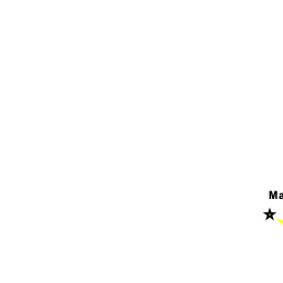
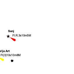
Senj is approached either via the Vinodolska channel leading under the road bridge linking the island of Krk to the mainland, which has a clearance of over 50 metres, or through the narrow channel between the S end of Krk and the small island of Prvic. The harbour lies on the N side of a headland dominated by a conspicuous 16th century castle and consists of a small bay partly protected on the N side by a short breakwater.
Depths in the entrance are 6.0 metres and at the quays 3.0 - 5.0 metres. Shelter is reasonable in moderate winds from NE round to S but poor in all other conditions. The harbour is untenable in strong winds from N round to SW.
Entrance
Senj is a port of entry/exit for Croatia. For details see Entrance: Croatia.
Berthing

Senj Harbour
Marinas & Yacht Clubs
None.
Anchorages
There is no suitable sheltered anchorage off Senj.
Amenities
| Facilities | |
|---|---|
| Water | N/A (Not Available) |
| Electricity | N/A |
| Toilets | N/A |
| Showers | N/A |
| Laundry | N/A |
| Garbage | Bins around the harbour |
| Supplies | |
| Fuel | Fuel from garage on the main road |
| Bottled gas | ? |
| Chandlers | None |
| Services | |
| Repairs | N/A |
| Internet | N/A |
| Mobile connectivity | ? |
| Vehicle rentals | N/A |
Provisioning
Supermarkets and other provisions shops in the town.
Eating out
Numerous bars and restaurants in the town.
Transportation
- Buses to Rijeka and Krk.
- Ferry service to Krk
- Domestic and international trains from Rijeka to Zagreb, Trieste, Ljubljana, Vienna, Munich and Salzburg.
Tourism
History
Give a short history of the port.
Places to Visit


The main attraction of the town is the well-restored 16th century Nehaj castle on the promontory overlooking the bay, which was built to repel the Ottoman invaders around 1558. Another, more unusual, attraction is the sundial erected on the 45th parallel which runs through the town, marking the exact halfway point between the North Pole and the Equator.
Friends
Contact details of "Cruiser's Friends" that can be contacted for local information or assistance.
Forums
List links to discussion threads on partnering forums. (see link for requirements)
Links
For other useful websites, see Croatia.
References
See Croatia.
Comments
We welcome users' contributions to the Wiki. Please click on Comments to view other users' comments, add your own personal experiences or recommend any changes to this page following your visit.
Verified by
Date of member's last visit to Senj and this page's details validated:
- Data compiled from web research (please update if possible)--Athene of Lymington 13:14, 21 July 2011 (BST)
If you provide a lot of info and this page is almost complete, change {{Page outline}} to {{Page useable}}.
| This page has an outline in place but needs completing. Please contribute if you can to help it grow further. Click on Comments to suggest further content or alternatively, if you feel confident to edit this page, click on the edit tab at the top and enter your changes directly. |
| |
|---|
|
Names: Lighthouse, Athene of Lymington |