Sifnos
From CruisersWiki
Istioploos (Talk | contribs) (→Radio Nets) |
Istioploos (Talk | contribs) |
||
| Line 24: | Line 24: | ||
===Approach and Navigation=== | ===Approach and Navigation=== | ||
| - | + | Approaches to the island are straightforward without navigational dangers, but | |
| + | |||
| + | <font color="red">Warning:</font> There can be very strong gusts when the ''meltemi'' blows, especially when entering [[#Kamares|Kamares]]. Reduce sail. | ||
===Check-in facilities=== | ===Check-in facilities=== | ||
| - | + | There is only one port, [[#Kamares|Kamares]], but there are many attractive anchorages. | |
===Ports and Popular Stops=== | ===Ports and Popular Stops=== | ||
| - | + | ==== Kamares==== | |
| - | + | [[Image:Sifnos_Kamares_h.jpg|250px|thumb|right|Chart of Kamares<br/>''Click for larger view'']] | |
| - | + | Kamares (Καμάρες) [36° 59.5' N 24° 40' E] is the only harbor in Sifnos. While it provides good shelter from the ''meltemi'' it seems to have a constant swell, this swell is very uncomfortable and at times can be dangerous. Go stern-to the quay. The bottom is sand and weed and sometimes the holding is not too good. Use plenty of spring lines. If the swell becomes too strong it is best to go to [[#Port_Vathi|Port Vathi]] about 4 nM south. | |
| + | |||
| + | <font color="red">Caution:</font> Do not enter the bay under sail. The gust are very strong and can be dangerous. | ||
| + | [[Image:Sifnos3.jpg|center|Fishing Boats at Kamares]] | ||
===Marinas & Yacht Clubs=== | ===Marinas & Yacht Clubs=== | ||
| - | + | None. | |
| - | + | ||
| - | + | ||
| - | + | ||
===Anchorages=== | ===Anchorages=== | ||
| - | + | ====Port Vathi==== | |
| - | + | [[Image:Sifnos_Vathi_h.jpg|250px|thumb|right|Chart of Port Vathi<br/>''Click for larger view'']] | |
| - | + | Port Vathi (Βαθύ)[36° 55.5' N 24° 41' E] is definitely the safest anchorage in Sifnos, I have been comfortable here while a force 8 gale raged for days. It is a pleasant setting, if somewhat remote from the rest of the island, with a nice sandy beach. Anchor off anywhere at 3-4 m, or take a line to the small mole at the N of the cove. The bottom is sand and provides good holding. | |
| - | + | [[Image:Sifnos4.jpg|center|Port Vathi]] | |
| + | |||
| + | ====Ayi Georgis==== | ||
| + | Ayi Georgis or Ayios Georgis is near the NW tip of the island. It is a very narrow inlet which provides excellent shelter from the meltemi. Also here is good place to buy ceramic ware directly from the shop. Unfortunately there is room for only one or two yachts. Anchor fore and aft at 8-10 m or take line to the little mole. | ||
| + | |||
| + | ====Fikiadha==== | ||
| + | [[Image:Sifnos_Fikiadha_h.jpg|250px|thumb|right|Chart of Fikiadha<br/>''Click for larger view'']] | ||
| + | Fikiadha [36° 54.4' N 24° 42.25' E] is pleasant and deserted inlet near the SW tip of the island. It offers good shelter for winds N through E to S. It is only open to the W. The bottom is sand and mud but it does not hold well uniformly. | ||
| + | [[Image:Sifnos_Fikiada.jpg|200px|thumb|center|The one and only House at Fikiada<br/>''Click for larger view'']] | ||
| + | |||
| + | ====Platis Yialos==== | ||
===Routes/Passages To/From=== | ===Routes/Passages To/From=== | ||
Revision as of 13:29, 10 May 2008
Sifnos
Background
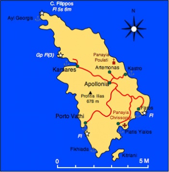
Sifnos (Σίφνος) is windy and hilly island with an area of 74 km2 and about 2000 inhabitants. Its highest peak, Profitis Ilias, is 678 m (2225 ft.) above sea level. Its west coast is barren but the east coast is greener and cultivated. The island is well known for its Cycladic architecture, it pottery, and it chefs. Several wealthy shipowner families come from Sifnos and maintain here beautiful houses.
In antiquity, Sifnos known as Meropia, was famous for its wealth from its gold and silver mines. This mines go back to the 3rd millennium BC and are the oldest mines discovered in Europe. The earliest inhabitants appear to have been Phoenicians who were replaced by Minoans who founded Minoa near the modern town of Apollonia, the island's capital. The Minoans were replaced by Ionian Greeks who lived near Ayios Andreas. The Meripians were not only very wealthy but were also greedy. They were discovered to have cheated the Oracle of Delphi by contributing instead of pure gold, lead eggs just gilded with gold. This discovery gave a good excuse, the anger of Apollo, to Polycrates of Samos to invade and plunder the island. After this the island declined.
In the middle ages most of the population lived near Kastro and were dominated by the Venetians who were succeeded by the Ottomans in 1617 AD. In the 17th century the Ottomans attempted to reopen the mines but were thwarted by French pirates supposedly hired by the islanders. After the Greek War of Independence Sifnos joined Greece and a French interest reopened the mines and operated them until 1925.
Charts
BA 1037 Nisís Falkonera to Nísos Ios
Iray-Tetra G33 Southern Cyclades
NIMA 41 Cavos Maleas to Cavos Kimis
Greek 415 Ydra to Sikinos
Radio Nets
Also see Cruiser's Nets
- Coast Guard - VHF channel 12, Tel. +30 2840 31 617
- Olympia Radio- VHF channel 03
Approaches to the island are straightforward without navigational dangers, but
Warning: There can be very strong gusts when the meltemi blows, especially when entering Kamares. Reduce sail.
Check-in facilities
There is only one port, Kamares, but there are many attractive anchorages.
Ports and Popular Stops
Kamares
Click for larger view
Kamares (Καμάρες) [36° 59.5' N 24° 40' E] is the only harbor in Sifnos. While it provides good shelter from the meltemi it seems to have a constant swell, this swell is very uncomfortable and at times can be dangerous. Go stern-to the quay. The bottom is sand and weed and sometimes the holding is not too good. Use plenty of spring lines. If the swell becomes too strong it is best to go to Port Vathi about 4 nM south.
Caution: Do not enter the bay under sail. The gust are very strong and can be dangerous.
Marinas & Yacht Clubs
None.
Anchorages
Port Vathi
Click for larger view
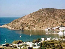
Port Vathi (Βαθύ)[36° 55.5' N 24° 41' E] is definitely the safest anchorage in Sifnos, I have been comfortable here while a force 8 gale raged for days. It is a pleasant setting, if somewhat remote from the rest of the island, with a nice sandy beach. Anchor off anywhere at 3-4 m, or take a line to the small mole at the N of the cove. The bottom is sand and provides good holding.
Ayi Georgis
Ayi Georgis or Ayios Georgis is near the NW tip of the island. It is a very narrow inlet which provides excellent shelter from the meltemi. Also here is good place to buy ceramic ware directly from the shop. Unfortunately there is room for only one or two yachts. Anchor fore and aft at 8-10 m or take line to the little mole.
Fikiadha
Click for larger view
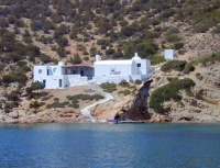
Fikiadha [36° 54.4' N 24° 42.25' E] is pleasant and deserted inlet near the SW tip of the island. It offers good shelter for winds N through E to S. It is only open to the W. The bottom is sand and mud but it does not hold well uniformly.
Platis Yialos
Routes/Passages To/From
Popular passages/routes, timing, etc.
Tourism & things to do ashore
List places of interest, tours, eateries, etc.
Fuel, Water, & Electricity
Laundry
Grocery Stores
Eateries
Motorbike & Car Rentals
Marine Stores & Facilities
Submit addresses and contact details of marine related businesses that are of interest to cruisers.
Repairs
Transportation
Transportation to mainland or other countries, etc.
References & Publications
Publications, Guides, etc.
Cruiser's Friends
Contact details of "Cruiser's Friends" that can be contacted for local information or assistance.
Forum Discussions
List links to discussion threads on the Cruiser Log Forum
External Links
- Sifnos (Wikipedia)
Personal Notes
Personal experiences?
.


