Sinop
From CruisersWiki
Sinop (Port of entry)
| | |
| GPS: | 42°01.3′N, 35°08.5′E |
|---|---|
| Gallery: | Photo gallery |
| Chartlet: | Local chartlet |
BackgroundTraces of human habitation near Sinop have been dated as far back as the 4,500 BC and there were Bronze Age settlements here dating from 3,000 to 2,700 BC and of the early Hittite period of 1,800 BC. During the 8th century BC colonists from Miletus established a trading post here and named it Sinope (Σινώπη) after the daughter of a river god. Sinope in turn established new colonies: Cotyora (Ordu), Cerasus (Giresun), and Trapezus (Trabzon). |
The cynic philosopher Diogenes (400-323 BC) was borne here and later moved to Athens after his father was accused of adulterating coins. Sinope was where in 399 BC Xenophon and the 10,000 Greek mercenaries first sighted the sea after a long march from Persia and exclaimed: Θάλαττα, θάλαττα (the sea, the sea). In 375 BC Sinope was conquered for a while by Datames the satrap of Cappadocia and then fell under the Persians. In 333 BC it became part of the Macedonian kingdom of Alexander the Great. Mithridates III and his son Pharmaces I took Sinope in 183 BC and made it the capital of their Kingdom of Pontus. This kingdom was overtaken by the Roman general Lucullus in 68 BC and Sinope was declared part of Rome by Pompey in 63 BC.
In the Byzantine period, Sinope declined but in the first half of the 6th century AD had a revival under Justinian, who built castles, aqueducts, bridges, and churches. It was taken from the Byzantines by emir Karatekin in 1084 and formed an emirate together with Kastamonu and Çankr but was later recaptured by the Byzantines. During the Fourth Crusade when the crusaders sacked Constantinople in 1204, Sinope came under the rule of the emperor of Trapezun Alexios I Komnenos. During this time the Genoese established here a trading post under an agreement with the Komneni. In 1124 the city was captured by the Selcuks but was retaken in 1254 by Manuel I Komnenos and was held until 1265 when again it fell to the Selcuks. In 1324 the city was captured by the Turkomans and renamed Sinop. They held it until 1461 when the Ottomans captured it under Mehmet II.
In 1853 the city was bombarded by Russian ships and badly damaged. This incident precipitated the Crimean War.
Charts
- BA
- 2214 The Euxine or Black Sea
- 2237 Inceburun to Isikli Burnu
- 1272 Sinop
- NIMA
- 55105 Eastern Part of the Black Sea
- Turkey
- 122 Inebulu - Inceburum
- 123 Inceburum-Bafra
- 1231 Sinop
Radio Nets
Also see Cruiser's Nets
Submit details of local radio Nets.
Weather
See Turkey.
The approaches to Sinop are straightforward.
Ports and Popular Stops
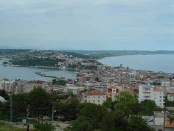
Sinop Harbor
| GPS: 42°01.3′N, 35°08.5′E
The harbor is very crowded with large, steel fishing boats and does not look particularly inviting. Warning: You may not find room in this crowded harbor, so be prepared to go elsewhere. |
Yakakent
| GPS: 42°01.3′N, 35°08.5′E
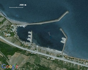
Yakakent is a harbor located about 30 nM west of Sinop and 55 nM east of Samsun. While the harbor is large and not very deep. It consists of an inner and an outer harbor. The inner harbor is usually full of fishing boats which were rafted along the quay under strong lights. One can anchor off either in the inner harbor or at the outer in 3 m. The bottom is soft mud and the holding is good. Warning: There are unmarked shallow areas in the outer harbor. |
Anchorages
Hamsilos
| GPS: 42°03.6′N, 35°02.6′E
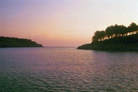
Hamsilos is an attractive cove on the Sinop Penninsula. It is a real cove, one of the three in the whole S shore of the Black Sea. The water in the cove is somewhat clearer than at the other places we had been in the Black Sea, but still murky. The cove is surrounded by green hills with pine trees. The place, other than its water, would have been idyllic were it not for a road which brings cars with picnickers. Anchor anywhere. |
Tourism & things to do ashore
List places of interest, tours, eateries, etc.
Fuel, Water, & Electricity
Laundry
Grocery & Supply Stores
Eateries
Internet/WiFi
Available?
Motorbike & Car Rentals
N/A.
Marine Stores & Facilities
Submit addresses and contact details of marine related businesses that are of interest to cruisers.
Repairs
N/A.
Garbage Disposal
Trash cans.
Transportation
?
Routes/Passages To/From
Popular passages/routes, timing, etc.
References & Publications
See Turkey.
Cruiser's Friends
Contact details of "Cruiser's Friends" that can be contacted for local information or assistance.
Forum Discussions
List links to discussion threads on partnering forums. (see link for requirements)
External Links
Personal Notes
The one time we sailed into Sinop Harbor, we did not find room to berth and had to leave. --Istioploos 14:48, 15 December 2008 (UTC)
Last Visited & Details Checked (and updated here)
Date of member's visit to this Port/Stop & this page's details validated:
- July 1999
 Istioploos 14:48, 15 December 2008 (UTC)
| |
|---|
| | HOMEPAGE | Wiki Contents | Mediterranean | Turkey | Black Sea | Sinop | |
.


