Sri Lanka
From CruisersWiki
Lighthouse (Talk | contribs) |
Lighthouse (Talk | contribs) (Replacing lost data) |
||
| Line 21: | Line 21: | ||
===Background=== | ===Background=== | ||
| - | + | The island of Sri Lanka lies in the [[Indian Ocean]], to the southwest of the Bay of Bengal and to the southeast of the Arabian Sea. It is separated from the Indian subcontinent by the Gulf of Mannar and the Palk Strait. According to Hindu mythology, a land bridge to the Indian mainland, known as Rama's Bridge, was constructed during the time of Rama by the vanara architect Nala. Often referred to as ''Adam's Bridge'', it now amounts to only a chain of limestone shoals remaining above sea level. According to colonial British reports, this is a natural causeway which was formerly complete, but was breached by a violent storm in 1480. The width of the Palk Strait is small enough for the coast of Sri Lanka to be visible from the furthest point near the Indian town of Rameswaram. The tear drop shaped island consists mostly of flat-to-rolling coastal plains, with mountains rising only in the south-central part. Amongst these are Sri Pada (Adams Peak) and the highest point Pidurutalagala, at 2,524 meters (8,281 ft). The Mahaweli ganga (Mahaweli river) and other major rivers provide fresh water to the population. | |
| - | + | ||
===Climate & Weather=== | ===Climate & Weather=== | ||
Revision as of 11:32, 27 August 2008
SRI LANKA
| Sri Lanka | |
 Sri Lanka | |
 Flag | |
| Capital: | Colombo |
|---|---|
| Language: | Sinhala, Tamil, English |
| Currency: | Sri Lankan Rupee |
| More notes about the country | |
Background
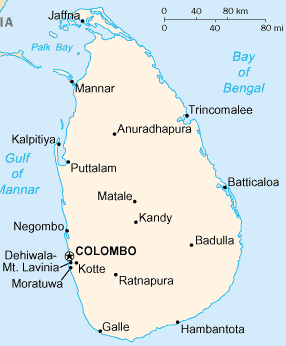
The island of Sri Lanka lies in the Indian Ocean, to the southwest of the Bay of Bengal and to the southeast of the Arabian Sea. It is separated from the Indian subcontinent by the Gulf of Mannar and the Palk Strait. According to Hindu mythology, a land bridge to the Indian mainland, known as Rama's Bridge, was constructed during the time of Rama by the vanara architect Nala. Often referred to as Adam's Bridge, it now amounts to only a chain of limestone shoals remaining above sea level. According to colonial British reports, this is a natural causeway which was formerly complete, but was breached by a violent storm in 1480. The width of the Palk Strait is small enough for the coast of Sri Lanka to be visible from the furthest point near the Indian town of Rameswaram. The tear drop shaped island consists mostly of flat-to-rolling coastal plains, with mountains rising only in the south-central part. Amongst these are Sri Pada (Adams Peak) and the highest point Pidurutalagala, at 2,524 meters (8,281 ft). The Mahaweli ganga (Mahaweli river) and other major rivers provide fresh water to the population.
Climate & Weather
Submit the climate details and sources of weather forecasting here.
Sources for weather forecasts:
Charts
Submit details of the charts required for safe navigation of the area.
Local Radio Nets
Submit details of Cruiser's Nets and VHF operating/calling channels here.
Arrival/Departure procedures
Submit any details about advance notification of arrival, etc.
Immigration
Submit details about immigration procedures here.
Customs
Details?
Health
Submit any health warnings/information.
Security
Details?
Ports & Popular Stops
Offshore Islands
Details?
Cruiser's Friends
Submit details/contacts of cruiser's "friends" that can be contacted in advance or on arrival - who can offer information and assistance to our cruising "family".
References & Publications
Books, Guides, etc.
Links to CruiserLog Forum discussions
Links to discussions on the CruiserLog Forum
External Links
Personal Notes
Personal experiences?
.