Torres Strait Islands
From CruisersWiki
Delatbabel (Talk | contribs) (→Islands in the Group) |
Delatbabel (Talk | contribs) (→Currents & Tides) |
||
| Line 30: | Line 30: | ||
==Currents & Tides== | ==Currents & Tides== | ||
| - | + | ==Approaches and Navigation== | |
| - | + | ||
| + | All of the way north inside the [[Great Barrier Reef]] in Queensland, past [[Port Douglas]], up the coast of the Cape York Peninsula and through the Torres Strait there is a two way channel (route) marked on the charts of the area. Although sticking to the channel will very much ensure that you do not run aground on any of the shoals both in the Torres Strait and elsewhere inside the reef, be aware that this channel is used for shipping as well as yachts. | ||
| + | |||
| + | The channel is two way, with no traffic separation scheme in place. Pilot boats operate in the channel and can be seen guiding some of the larger shipping through the channel. | ||
| + | |||
| + | A constant visual watch must be maintained while following this route, and a listening watch on VHF 16 is also mandatory. | ||
| + | |||
| + | Although the route itself runs through the '''Prince of Wales Channel''' inside the Torres Strait, it's also possible for a sailing vessel to pass through the shallower but wider waters of the '''Endeavour Strait''' to the south of the channel. Be aware of shoal patches on the western end of this strait and you should be OK. | ||
==Regional Radio Nets== | ==Regional Radio Nets== | ||
Revision as of 10:38, 13 October 2014
Torres Strait Islands Cruising Guide
An online cruising guide for yachts sailing around the Torres Strait Islands, in Queensland, Australia
The Torres Strait Islands are a group of islands which lie in Torres Strait, the waterway separating far northern continental Australia's Cape York Peninsula and the island of New Guinea.
The islands are mostly part of Queensland, with a special status fitting the native (Melanesian) land rights. A few islands very close to the coast of mainland New Guinea belong to the Western Province of Papua New Guinea, most importantly Daru Island.
Cruising the region
Add any cruising recommendations. If not applicable delete this section.
- Australian Hydrographic Office
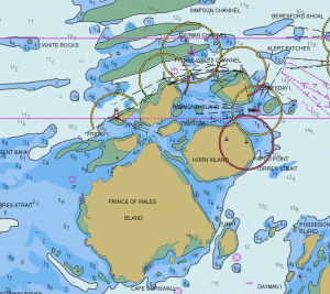
- Aus292 -- Australia Torres Strait - Queensland - Adolphus Channel to Prince of Wales Channel (1:75000)
- Aus293 -- Australia North Coast - Torres Strait - Prince of Wales Channel (1:37500)
- Aus294 -- Australia - North Coast - Torres Strait - Endeavour Strait (1:75000)
- Aus296 -- Australia North Coast - Torres Strait - Prince of Wales Channel to Varzvin Passage (1:37500)
- Aus297 -- Great North East Channel - Basilisk Passage to Moon Passage (1:50000)
- Aus299 -- Australia North Coast - Torres Strait - Approaches to Thursday Island (1:12500)
Note that all of the above paper charts are available in S63 electronic (vector) format: http://www.hydro.gov.au/prodserv/important-info/echarting-info.htm
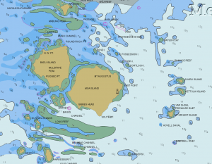
There are many shallows, banks, and reefs within the Torres Strait. Although the main shipping passages are well marked, anyone venturing into the region for the first time would be well advised to have reliable and accurate charts.
Weather and Winds
Currents & Tides
All of the way north inside the Great Barrier Reef in Queensland, past Port Douglas, up the coast of the Cape York Peninsula and through the Torres Strait there is a two way channel (route) marked on the charts of the area. Although sticking to the channel will very much ensure that you do not run aground on any of the shoals both in the Torres Strait and elsewhere inside the reef, be aware that this channel is used for shipping as well as yachts.
The channel is two way, with no traffic separation scheme in place. Pilot boats operate in the channel and can be seen guiding some of the larger shipping through the channel.
A constant visual watch must be maintained while following this route, and a listening watch on VHF 16 is also mandatory.
Although the route itself runs through the Prince of Wales Channel inside the Torres Strait, it's also possible for a sailing vessel to pass through the shallower but wider waters of the Endeavour Strait to the south of the channel. Be aware of shoal patches on the western end of this strait and you should be OK.
Regional Radio Nets
Sheila Net on 8161kHz at 2200UTC (0800 Australian Eastern Standard Time) is the most active radio net covering this region.
Also see World Cruiser's Nets.
Islands in the Group
This section is usually better served by a table. However, if there are only a few islands in the group you can reduce the table to a simple list.
|
![]() = Port of entry,
= Port of entry, ![]() = Marina,
= Marina, ![]() = Harbor,
= Harbor, ![]() = Anchorage,
= Anchorage, ![]() = Needs data.
= Needs data.
See also List of Torres Strait Islands on wikipedia.
Things to do Ashore
See individual islands.
Routes/Passages To/From
Cruiser's Friends
Contact details of "Cruiser's Friends" that can be contacted for local information or assistance.
Forum Discussions
List links to discussion threads on partnering forums. (see link for requirements)
External Links
- Torres Strait on wikipedia
- Torres Strait Islands on wikipedia
References & Publications
Books, Guides, etc. Use the Reference template or not at your discretion. For example:
-
{{Reference|Rod Heikel|Greek Waters Pilot Imray||Laurie and Wilson, Cambridgeshire|9780852889718}}, expands to - Rod Heikell, Greek Waters Pilot Imray, Laurie and Wilson, Cambridgeshire, ISBN 9780852889718
- Author, Title, Publisher, ISBN ISBN number
- Author, Title, Publisher, ISBN ISBN number
You may want to remove the above entries and use instead a link to the Country or Region that lists the relevant references. If so enter, after removing {{MagentaText|xx}}, the following:
See [[Country or Region#References_&_Publications|Coutry or Region]].
If you do not use the above link, please remove it.
Personal Notes
Personal experiences?
Last Visited & Details Checked (and updated here)
Date of member's visit to this Island Group & this page's details validated:
|
|---|
|
Names: Delatbabel |
| |
|---|
| | HOMEPAGE | Wiki Contents | Australia | Queensland | Torres Strait Islands | |

