Trans-Atlantic, Europe to Caribbean
From CruisersWiki
m (Text replace - " <small>[''add 3 tildes (<nowiki>~~~</nowiki>) on the name line'']</small>" to "") |
(→Navigation Charts Required) |
||
| Line 41: | Line 41: | ||
==Navigation Charts Required== | ==Navigation Charts Required== | ||
* | * | ||
| - | * | + | *Imray Chart 100 (conical projection) North Atlantic Passage Chart |
| + | E1 - Azores, | ||
| + | E2 - Canaries, | ||
| + | E3 - Maderia and Porto Santo, | ||
| + | E4 - Cape Verde, | ||
| + | E5 - Bermuda, | ||
==Distance & Duration== | ==Distance & Duration== | ||
Revision as of 19:14, 16 January 2012
Trans-Atlantic Passage, Europe to Caribbean
| Trans-Atlantic Passage Europe to Caribbean | |
| MORE notes about the passage |
Introduction
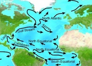
Probably the most popular ocean crossing. The majority of it is in the trade wind belt. There is Atlantic Rally for Cruisers (ARC) which takes this route every year. It is well organized, and offers a lot of information and help for cruisers taking this passage. For first timers it is widely suggested to go with ARC. ARC starts every November, and arrives to the Caribbean mostly in December.
Climate & Weather Information
Expected climatic & weather conditions for this passage
Sources of weather forecast information for this passage.
- http://www.passageweather.com/ Nort Atlantic/Mediterranean to caribbean
- Imarsat-C – High Seas weather text forecast and warnings which come automatically to the unit for the entire North Atlantic (whole world actually)
- Navtex – Also automatic text weather forecasts and warnings for the entire North Atlantic.
- Radio Weather Fax Charts, received automatically
- SSB – weather routing advice from “South Bound II” which provides detailed analysis and recommendations to individual vessels by SSB schedule on frequency 12359.0, log on at 1900 UTC, transmit and receive beginning at 2000 UTC
- Daily copies of NOAA’s “Atlantic Briefing” sent by iridium e-mail to the ship. This consists of 12, 24, 48 and 96-hour maps and forecasts of the above maps.
- Herb Hilgen provides a daily ship-routing/weather forecasting service as a hobby, on marine HF/SSB frequency12359.0 starting at 2000 UTC until completion of traffic.
Weather Windows
The passage is generally undertaken in early November after Hurricane season and before the Christmas winds set in.
Hurricane season is officially June through November.
Christmas winds are the northerlies in the winter, growing to severe Northers in February. These are usually dangerous only near land, when they become "rage seas" (in the Bahamas, particularly) and breaking waves in most north-facing anchorages in the Caribbean.
Weather can also be nasty in winter in the Med, but from the western Med, starting the passage in end of February is realistic.
Trade winds are stronger in the winter than in the summer, and stronger when the Atlantic Oscillation is warm.
Radio Nets
Also see World Cruiser's Nets
- Herb's website - Just two words needed:- "Got Herb?" I can't recommend him highly enough. Alan Teed 10:56, 14 December 2007 (MST) Yacht Moonstruck
- Imray Chart 100 (conical projection) North Atlantic Passage Chart
E1 - Azores, E2 - Canaries, E3 - Maderia and Porto Santo, E4 - Cape Verde, E5 - Bermuda,
Distance & Duration
- Distance = approx 3000 miles
- Duration = 3 - 5 weeks
Possible Departure Points
Route/Suggested Stopovers
There are two traditional rules:
- Sail south from Gibraltar until the butter melts... and then turn right.
- 20/30 : go south to 20N, 30W to reach the trade belt, and then go straight to the Caribbean.
The actual route depends on several factors, like weather and destination.
There are possible stopovers in the Canaries and Cape Verde, but it seems that people like to stop only in one of them. ARC goes through the Canaries, leaving Cape Verde as a departure point for vessels having problems.
The Canaries is a good stopover for those coming from Northern Europe, but for those coming from the Med, it seems to be more logical to have a stopover in Cape Verde, and skip the Canaries.
Leaving the Canaries can be interesting as there are wind acceleration zones, caused by the wind funneling between the islands, so there are frequently gale force winds that persist for 8 hours or so after departure.
Possible Arrival Ports
Passage Description
FULL description of this passage.
Forum Discussion Topics
List links to discussion threads on partnering forums. (see link for requirements)
External Links
Links to relevant websites.
References
Books, guides, etc.
Personal Notes
Personal experience?
|
|---|
|
Names: |
| |
|---|
| | HOMEPAGE | Wiki Contents | North Atlantic | Caribbean | Gibraltar | |
.
