Vlore
From CruisersWiki
m (bot: Change External Links) |
m (bot: Berthing Options) |
||
| Line 28: | Line 28: | ||
{{hold vertical}} | {{hold vertical}} | ||
| - | + | Berthing | |
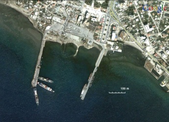
{{Image right|Albania_VlorePortS.jpg |Satellite view of the Harbour }} | {{Image right|Albania_VlorePortS.jpg |Satellite view of the Harbour }} | ||
There are two large breakwaters perpendicular to the shoreline and at some large distance between them. This construct is the harbour. There were a number of craft, all moored side-to, on the two breakwaters in such a way that there is almost no space between them. These craft are mostly mothballed old ships plus one or two cargo ships, unloading, and a few pilot boats. | There are two large breakwaters perpendicular to the shoreline and at some large distance between them. This construct is the harbour. There were a number of craft, all moored side-to, on the two breakwaters in such a way that there is almost no space between them. These craft are mostly mothballed old ships plus one or two cargo ships, unloading, and a few pilot boats. | ||
Revision as of 23:51, 2 May 2016
Vlorë, Albania
| Vlore
| |
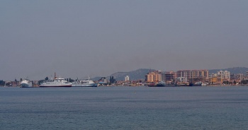
Vlorë (Greek: Aulón - Αυλών) is one of the oldest cities of Albania. It was founded by Ancient Greeks in the 6th century BC and named Aulón. Its name, still used today in Greece, means valley. It is the second largest port city of Albania, after Durrës, with a population of about 94,000 (2008 estimate). The city of Vlorë is at some distance from the port.
Charts
See Albania.
Communication
- Albanian Coast Guard - VHF 11
Also see World Cruiser's Nets.
Weather
See Albania.
There are no dangers in the approach other than those mentioned above.
Entrance
Clearance procedures here are more relaxed then in Sarandë and Durrës. --FANEROMENI ![]() (July 2007)
(July 2007)
Berthing
There are two large breakwaters perpendicular to the shoreline and at some large distance between them. This construct is the harbour. There were a number of craft, all moored side-to, on the two breakwaters in such a way that there is almost no space between them. These craft are mostly mothballed old ships plus one or two cargo ships, unloading, and a few pilot boats.
Caution: There can be some sunken craft in the harbour.
Marinas & Yacht Clubs
The only marina in Albania is Orikum.
Anchorages
List details of all safe anchorages in the area.
Yacht Repairs and Services
None.
Tourism and Things to do Ashore
Tourism
None.
Grocery & Supply Stores
Eateries
Internet/WiFi
Available?
Laundry
Motorbike & Car Rentals
Garbage Disposal
?
Transportation
Transportation (local and/or international)
Routes/Passages To/From
Popular passages/routes, timing, etc.
Cruiser's Friends
Contact details of "Cruiser's Friends" that can be contacted for local information or assistance.
Forum Discussions
List links to discussion threads on partnering forums. (see link for requirements)
Links
- Wikipedia - Vlorë at the Wikipedia
See also Albania
References & Publications
See Albania.
Comments
We welcome users' contributions to the Wiki. Please click on Comments to view other users' comments, add your own personal experiences or recommend any changes to this page following your visit.
Verified by
Date of member's last visit to Vlore and this page's details validated:
- June 2007 FANEROMENI

| This is a usable page of the cruising guide. However, please contribute if you can to help it grow further. Click on Comments to add your personal notes on this page or to discuss its contents. Alternatively, if you feel confident to edit the page, click on the edit tab at the top and enter your changes directly. |
| |
|---|
|
Names: Lighthouse, FANEROMENI |
| |
|---|
|
Names: Lighthouse, FANEROMENI |

