Vrgada
From CruisersWiki
m (bot: Last Visited) |
m (bot: Move Offshore Islands) |
||
| Line 60: | Line 60: | ||
{{Coord legacy|43|50.91|N|15|30.69|E|}} - {{Chartlet link| lat= 43.8485115213476| lon= 15.51148367179747| zoom= 17|}}<br / > | {{Coord legacy|43|50.91|N|15|30.69|E|}} - {{Chartlet link| lat= 43.8485115213476| lon= 15.51148367179747| zoom= 17|}}<br / > | ||
The anchorage of U. Kranje is located at the SE end of the island overlooking the islet of Murvenjak and cluster of smaller islets surrounded by fish farms. It is a popular anchorage in summer and offers good shelter in moderate northerly winds but is completely open S and SE. Anchor in 4.0 - 5.0 metres, taking a line ashore if preferred. Holding is good in sand and weed. There are no facilities ashore. | The anchorage of U. Kranje is located at the SE end of the island overlooking the islet of Murvenjak and cluster of smaller islets surrounded by fish farms. It is a popular anchorage in summer and offers good shelter in moderate northerly winds but is completely open S and SE. Anchor in 4.0 - 5.0 metres, taking a line ashore if preferred. Holding is good in sand and weed. There are no facilities ashore. | ||
| - | |||
| - | |||
| - | |||
| - | |||
==Yacht Services and Repairs== | ==Yacht Services and Repairs== | ||
Revision as of 12:25, 23 April 2016
An online cruising guide for yachts sailing to Vrgada Island in Croatia.
| Vrgada
| |
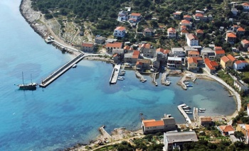
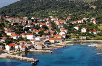
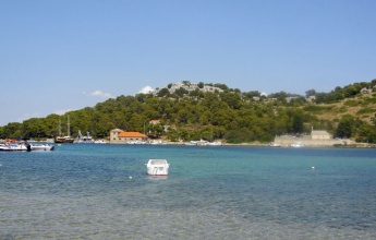
The small island of Vrgada lies off the mainland coast of Croatia six miles SSE of the harbour of Biograd. The island is situated halfway between the larger islands of Pasman to the NW and Murter to the SE. The island has a total area of only around 1.4 square miles but - for its size - a thriving population of nearly 250, mostly in the main settlement of Vrgada on the N coast. The island’s main harbour is in the bay of U. Luka at the NE coast of the island, which offers good protection except in E winds, when the sandy bay of U. Sv. Andrija immediately W of a headland separating it from U. Luka is a better option. A further anchorage, U. Kranje on the S coast of the island, offers better shelter in N winds. There are several fish farms in the channels between the small islets to the S.
Charts
- British Admiralty
- 2711
- 2773
- Croatian charts
- MK14
- Imray
- M25
Radio Nets
Also see World Cruiser's Nets.
Weather
Diurnal winds among the islands are mostly moderate during the summer months, predominantly from NW and rarely exceeding force 4/5, although gusting is common in narrow channels between islands and on the lee side of headlands. At night, katabatic winds off the mountains affect some of the islands close to the mainland coast. During early spring and (especially) autumn conditions can be more unsettled, occasionally accompanied by violent thunderstorms - luckily of short duration - with winds of 30-35 knots or more and vicious, steep seas. In the winter the sudden, violent N wind off the mountains, the bora, is much to be feared, especially along the coast from Rijeka down to Zadar, although its effects can be felt as far south as Split.
Equally prevalent in winter - although not uncommon in summer - is the scirocco, a S/SE wind that blows up from North Africa, usually in advance of a depression moving E across the Mediterranean. Unlike the bora, the scirocco only occasionally exceeds gale force, but is still a phenomenon to be wary of, especially if on a lee coast.
For sources of weather forecasting, see Croatia.
Berthing Options
The berthing options on the island consist of the two harbours of U. Luka and U. Sv. Andrija on the NE coast and the anchorage of U. Kranje at the SE end of the island.
Ports
U. Luka
Template:Coord legacy - Chartlet
The harbour of U. Luka lies on the E side of a promontory which shelters it from W. An islet, O. Artina, lies just off the promontory and is connected to it by a shallow spit. The harbour consists of a series of short jetties protected by a long breakwater with a red light structure on the end extending from the S shore. Berth alongside or stern/bows-to the inside of the breakwater using your anchor as space permits. Depths on the breakwater are 3.5 - 4.0 metres. Depths at the jetties further in are 2.0 metres or less. Shelter in the harbour is good in winds from NW through W to SE but the bay is exposed in winds from N and E.
U. Sv. Andrija
Template:Coord legacy - Chartlet
The bay of U. Sv. Andrija lies on the W side of the promontory, just ‘round the corner’ from U. Luka. Although it is relatively shallow, it offers better shelter with anything E in the wind. Anchor in the middle of the bay in 3.0 metres. The holding is good in sand. The bay is open NW and can be uncomfortable in the afternoon sea breezes. Note that there is a shoal patch on the headland on the E side of the bay, marked with a W cardinal mark.
Marinas & Yacht Clubs
None.
Anchorages
U. Kranje
Template:Coord legacy - Chartlet
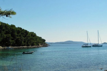
The anchorage of U. Kranje is located at the SE end of the island overlooking the islet of Murvenjak and cluster of smaller islets surrounded by fish farms. It is a popular anchorage in summer and offers good shelter in moderate northerly winds but is completely open S and SE. Anchor in 4.0 - 5.0 metres, taking a line ashore if preferred. Holding is good in sand and weed. There are no facilities ashore.
Yacht Services and Repairs
None.
Fuel, Water, & Electricity
None.
Things to do Ashore
Tourism
There is little do on the island, but lovers of peace and quiet will find a good haven here - except during high tourist season, when day trippers flock to its several good beaches, especially in U. Sv. Andrija.
Grocery & Supply Stores
Small provisions shop in Vrgada village.
Eateries
Restaurant in U. Luka.
Internet/WiFi
None.
Laundry
None.
Motorbike & Car Rentals
None.
Transportation
Tripper boats only.
Routes/Passages To/From
See Croatia.
Cruiser's Friends
Contact details of "Cruiser's Friends" that can be contacted for local information or assistance.
Forum Discussions
List links to discussion threads on partnering forums. (see link for requirements)
External Links
- Vrgada at the Wikipedia
- Vrgada tourism
For other useful websites, see Croatia.
References & Publications
See Croatia.
Comments
We welcome users' contributions to the Wiki. Please click on Comments to view other users' comments, add your own personal experiences or recommend any changes to this page following your visit.
Verified by
Date of member's last visit to Vrgada and this page's details validated:
- July 2004 --Athene of Lymington 15:04, 21 April 2012 (BST)
| This is a usable page of the cruising guide. However, please contribute if you can to help it grow further. Click on Comments to add your personal notes on this page or to discuss its contents. Alternatively, if you feel confident to edit the page, click on the edit tab at the top and enter your changes directly. |
| |
|---|
|
Names: Athene of Lymington |


