Karlobag
From CruisersWiki
| Karlobag
| |
| | |
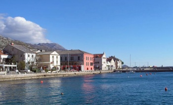
The harbour of Karlobag lies on the mainland coast of Croatia in the Velebitski channel, opposite the island of Pag and under the Velebit mountain range. The town itself is ancient, dating back well before the Roman period, but rebuilt in the 17th century following destruction by the Turks in 1525 and the Venetians in 1592. Although an attractive resort and an excellent base for walking in the Velebit mountains, the harbour is quite open and does not offer good shelter. It is a place to be avoided if there is any risk of a bora or, indeed, any fresh to strong winds from NW round to SE. In settled weather, however, it is a rewarding place to visit and little frequented by cruising yachts.
Charts
See Kvarner Gulf.
Weather
See Croatia.
Passages
See Croatia.
Islands
Communication
Add here VHF channel for the coastguard, harbor masters. etc.
Also see Cruiser's Nets
Karlobag is approached either from NW via the Velebitski channel around the northern end of the island of Pag or from SE through the narrow but deep channel of Ljubacka Vrata. A bridge crosses the latter channel, connecting Pag with the mainland. The bridge has an air clearance of 35 metres. In the approach from NW, stay at least half a mile offshore to avoid the shoals stretching for some three miles along the coast NW of Karlobag. There are no dangers in the approach from S. The town and a church belfry to the S are conspicuous from some distance. Shelter is reasonable only in moderate winds from NE round to E but poor in all other conditions. The harbour is untenable in strong winds from N round to SE.
Berthing
Karlobag Harbour
Marinas & Yacht Clubs
None.
Anchorages
Baska Draga
Amenities
| Facilities | |
|---|---|
| Water | N/A (Not Available) |
| Electricity | N/A |
| Toilets | N/A |
| Showers | N/A |
| Laundry | N/A |
| Garbage | Bins around the harbour |
| Supplies | |
| Fuel | Fuel from garage on the main road NW of the town |
| Bottled gas | ? |
| Chandlers | None |
| Services | |
| Repairs | N/A |
| Internet | N/A |
| Mobile connectivity | ? |
| Vehicle rentals | ? |
Provisioning
Supermarkets and other provisions shops in the town.
Eating out
Several bars and restaurants in the town.
Transportation
Tourism
Places to Visit
The town’s most important historical building is an early 18th century Capuchin monastery, which has a small collection of religious art. If the weather is settled enough, there are also some excellent walking trails in the Velebit mountains behind the town.
Friends
Contact details of "Cruiser's Friends" that can be contacted for local information or assistance.
Forums
List links to discussion threads on partnering forums. (see link for requirements)
Links
- Karlobag at the Wikipedia
For other useful websites, see Croatia.
References
See Croatia.
Comments
We welcome users' contributions to the Wiki. Please click on Comments to view other users' comments, add your own personal experiences or recommend any changes to this page following your visit.
Verified by
Date of member's last visit to Karlobag and this page's details validated:
- Data compiled from web research (please update if possible)--Athene of Lymington 14:38, 21 July 2011 (BST)
If you provide a lot of info and this page is almost complete, change {{Page outline}} to {{Page useable}}.
| This page has an outline in place but needs completing. Please contribute if you can to help it grow further. Click on Comments to suggest further content or alternatively, if you feel confident to edit this page, click on the edit tab at the top and enter your changes directly. |
| |
|---|
|
Names: Haiqu, Athene of Lymington |


