Kemer Sea of Marmara
From CruisersWiki
| Kemer
| |
| | |
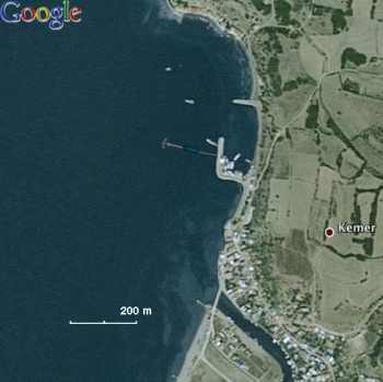
Kemer is a conveniently located anchorage about 17.5 nM east of Gelibolu and a few miles west of Karabiga.
Charts
See Sea of Marmara.
Weather
See Turkey.
Passages
List popular passages/routes, timing, etc.
Communication
Also see World Cruiser's Nets.
Approaches to Kemer are straight forward.
Berthing
It is best to anchor E of the small harbor and take a line to the mole. The harbor is very dirty and full of fishing boats. There is hamlet E of the harbor. No facilities. The water is very murky.
Amenities
| Facilities | |
|---|---|
| Water | N/A (Not Available) |
| Electricity | N/A |
| Toilets | N/A |
| Showers | N/A |
| Laundry | N/A |
| Garbage | ? |
| Supplies | |
| Fuel | N/A |
| Bottled gas | ? |
| Chandlers | None |
| Services | |
| Repairs | N/A |
| Internet | ? |
| Mobile connectivity | ? |
| Vehicle rentals | N/A |
Provisioning
Very modest.
Eating out
N/A.
Transportation
List transportation (local and/or international.)
Tourism
Just a very modest fishing village. Take a nice walk.
Friends
Contact details of "Cruiser's Friends" that can be contacted for local information or assistance.
Forums
List links to discussion threads on partnering forums. (see link for requirements)
Links
References
See Turkey.
Comments
We welcome users' contributions to the Wiki. Please click on Comments to view other users' comments, add your own personal experiences or recommend any changes to this page following your visit.
Verified by
Date of member's last visit to Kemer Sea of Marmara and this page's details validated:
- June 1998 --Istioploos

 Travels with S/Y Thetis
| This is a usable page of the cruising guide. However, please contribute if you can to help it grow further. Click on Comments to add your personal notes on this page or to discuss its contents. Alternatively, if you feel confident to edit the page, click on the edit tab at the top and enter your changes directly. |
| |
|---|
|
Names: Istioploos, Lighthouse |
