Baie de Bourail
From CruisersWiki
Baie de Bourail, New Caledonia
| | |
| | DD°M.M′N/S, DD°M.M′E/W |
|---|---|
| | Photo gallery |
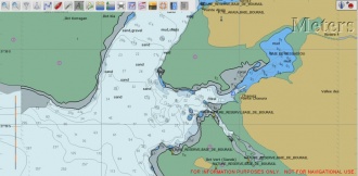
| | Local chartlet |
Overview
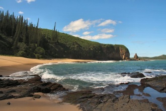
Baie de Bourail is one of the most scenic places on the west coast of New Caledonia. It has unusual rock formations, a very popular swimming and surfing beach, the beautiful Baie des Torues and the marine reserve of L'ile Verte. The large Baie de Bourail is open to the ocean swell and does not make a comfortable anchorage, but the nearby Baie N'diadiou is comfortable and sheltered. The town of Bourail (pop. ~5,000) is about 5 km away by road. Note that that it is possible to take a dinghy up the river on the south side of the bay all the way to Bourail, assuming that you are happy with the anchorage and can cross the bar into the river.
There is a small beachside community, but no facilities.
Cruising the region
The section of the west coast of New Caledonia between Baie D'Ouarai (Ile Lebris anchorage and Voh, a distance of about 80nm, is not navigable inside the barrier reef. Fortunately, there are a number of accessible, secure anchorages that can be reached through well marked passes and the maximum distance between anchorages is only about 30 nm. Bearing in mind that the ideal cruising time in New Caledonia is winter, when days are short, and the need to maintain good sun angles when navigating around coral, there is a definite need for relatively short daily distances.
The next anchorage to the north is about 30 nm away at Port de Mueo. This involves a 25 nm run outside the reef, entering the well marked Passe De Mueo and then traveling some 5 nm in to the anchorage.
The next anchorage to the south is Ile Lebris . This requires a 20 nm run outside the reef, entering the wide (0.6nm) Passe D'Ouarai and a 2.5 nm run in to Ile Lebris where there are a couple of anchorages depending on the conditions.
Local Weather
Local weather conditions?
Sources for Weather forecasts:
Local forecasts are, of course, in French, but non-French speakers should find them relatively easy to understand. A very useful vocabulary can be found at How to Understand French Weather Forecasts for Sailors.
The main source of weather information for the area around New Caledonia is Meteo France Nouvelle-Calédonie. The marine section provides a 6 day forecast for the whole region, with details for each of the passes through the barrier reef.
Nouméa radio broadcasts the weather report in French on VHF 16, everyday at 6:30, 9:30, 15:15, 18:30.
There is a set of repeater channels allowing receipt of weather info anywhere in the country:
- Nouméa area: VHF 26
- Southern portion of the Grande Terre: VHF 28
- Isle of Pines and the Southern Lagoon: VHF 25
- Grande Terre North West coast: VHF 25
- Northern portion of Grande Terre: VHF 24
- Ouvea: VHF 23
- Lifou: VHF 26
- Maré: VHF 87
Charts
Submit the chart details that are required for safe navigation.
- Chart Source
- Chart No
- Chart No
Radio Nets
Also see World Cruiser's Nets
The entrance to Baie de Bourail is not marked, but is over a mile wide, is deep and free from isolated dangers. Ilot Verte is clearly visible on the SW side of the bay. Both this and Pointe Akaia are surrounded by extensive drying reefs.
Check-in facilities (for Customs and Immigration)
You must clear Customs at Noumea before proceeding anywhere else in New Caledonia.
Offshore Islands and Groups
List Islands
Marinas & Yacht Clubs
- None
Anchorages
Baie de Bourail is open to the ocean swell which penetrates all the way to the beach (you can clearly see the swell in the Google Map image). This makes anchoring in the main bay problematic at best and certainly uncomfortable.
- The only secure anchorage is in Baie N'diadiou on the south east side of Baie de Bourail. The channel into Baie N'diadiou is narrow with reefs on both sides, with a couple of shoal patches on the southern side. Ideally, you should approach in good lighting with suitable sun angles. By the time you are in the area of the anchorage under Pic N'diadiou, the water is no longer clear and a careful approach by depth sounder is required.
- Access to the main beach requires either a long dinghy trip in potentially rough conditions around the reef off Pointe Akaia or risking a day anchorage in the main bay. A potential day anchorage can be had off Pointe Akaia, close to the river mouth. In good conditions, it is possible to take a dinghy into the river, but the mouth is shallow and breaks in any swell, so great care is required. Once across the river bar, it is easy to land on the beach. Note that if you cross the bar into the river, conditions may change making it difficult to recross later in the day. Use either of these approaches at your own risk. Only the Baie N'diadiou anchorage is mentioned in the Cruising Guide to New Caledonia.
Yacht Repairs and Services
Marine Stores
Submit addresses and contact details of marine related businesses that are of interest to cruisers.
- None
Repairs/Yards
- None
Fuel, Water, & Electricity
- Fuel
- Not available
- Water
- water notes
- Electricity
- None
Things to do Ashore
Tourism
- The beautiful mile long beach is very popular for swimming and surfing.
- Bon Homme at the northern end of the beach is a spectacular rock formation. The lookout above the Bon Homme provides a great view of the surrounding country side and the bay.
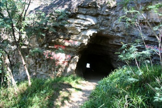
- Roche Percee is a weird natural tunnel through the hill behind Bon Homme.
- La Baie des Tortues is a small, but beautiful beach area. It is not ideal for swimming, but a great spot to soak up delightful scenery.
Grocery & Supply Stores
- None except at Bourail, 5km from the anchorage.
Eateries
- None
Internet/WiFi
Available?
Laundry
- No
Motorbike & Car Rentals
- No
Garbage Disposal
?
Transportation
Transportation (local and/or international)
Routes/Passages To/From
Popular passages/routes, timing, etc.
Cruiser's Friends
Contact details of "Cruiser's Friends" that can be contacted for local information or assistance.
Forum Discussions
List links to discussion threads on partnering forums. (see link for requirements)
External Links
Links to relevant websites.
References & Publications
Publications, Guides, etc.
Personal Notes
Personal experiences?
Last Visited & Details Checked (and updated here)
Date of member's visit to this Port/Stop & this page's details validated:
- June 2010 - Pedro
|
|---|
|
Names: Pedro |
| |
|---|
| | HOMEPAGE | Wiki Contents | South Pacific | New Caledonia | Baie de Bourail | |


