Baie de Pam
From CruisersWiki
Baie de Pam, New Caledonia
| | |
| | 20°14.2′S, 164°17.8′E |
|---|---|
| | Photo gallery |
| | Local chartlet |
Overview
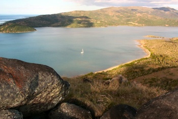
Baie De Pam is a very sheltered anchorage in a deep bay. The surrounding area is mostly uninhabited and there are no facilities in the area. The bay is the most sheltered anchorage in the NE of Grande Terre until Hienghene is reached.
Cruising the region
Baie de Pam is primarily a overnight anchorage when traveling to or from the Northern lagoon. The coast to the south is spectacular, though there is a limited number of anchorages. To the north, there is a maze of reefs and islands that continue on into the Northern lagoon area. There are a variety of anchorages amongst the northern reefs and islands, but none as sheltered as Pam.
Heading south, the next reasonable anchorage is Balade, at a distance of about 10nm. This is a straight forward sail inside the barrier reef, with no dangers..
Charts
Submit the chart details that are required for safe navigation.
- Chart Source
- Chart No
- Chart No
Weather
Local weather conditions?
Sources for Weather forecasts:
Local forecasts are, of course, in French, but non-French speakers should find them relatively easy to understand. A very useful vocabulary can be found at How to Understand French Weather Forecasts for Sailors.
The main source of weather information for the area around New Caledonia is Meteo France Nouvelle-Calédonie. The marine section provides a 6 day forecast for the whole region, with details for each of the passes through the barrier reef.
Nouméa radio broadcasts the weather report in French on VHF 16, everyday at 6:30, 9:30, 15:15, 18:30.
There is a set of repeater channels allowing receipt of weather info anywhere in the country:
- Nouméa area: VHF 26
- Southern portion of the Grande Terre: VHF 28
- Isle of Pines and the southern lagoon: VHF 25
- Grande Terre North west coast: VHF 25
- Northern portion of Grande Terre: VHF 24
- Ouvea: VHF 23
- Lifou: VHF 26
- Maré: VHF 87
Passages
Popular passages/routes, timing, etc.
Islands
List Islands
Communication
Also see World Cruiser's Nets
There are significant reefs on both sides of the mouth of the bay, but these are identified by navigation markers.
Entrance
Not applicable
Marinas & Yacht Clubs
Not applicable
Anchorages
The recommended anchorage is in the cove behind Pointe Nen'diaran. Depending on wind and swell conditions, other areas of the bay may be suitable for anchorage.
Yacht Repairs and Services
Marine Stores
Not applicable
Repairs/Yards
Not applicable
Fuel, Water, & Electricity
Not applicable
Things to do Ashore
Tourism
- There are excellent views to be had from the surrounding hills. The summit of Ille Pam provides views of the northern reefs and inland.
- The river at the head of the bay may provide opportunities for interesting dinghy exploration.
- There are mining ruins on the shore near Pointe Nen'diaran.
Grocery & Supply Stores
- None
Eateries
- None
Internet/WiFi
Not applicable
Laundry
Not applicable
Motorbike & Car Rentals
- None
Garbage Disposal
None
Transportation
Transportation (local and/or international)
- None
Friends
Contact details of "Cruiser's Friends" that can be contacted for local information or assistance.
Forums
List links to discussion threads on partnering forums. (see link for requirements)
Links
Links to relevant websites.
References
Publications, Guides, etc.
Comments
We welcome users' contributions to the Wiki. Please click on Comments to view other users' comments, add your own personal experiences or recommend any changes to this page following your visit. Personal experiences?
Last Visited & Details Checked (and updated here)
- July 2010 - Pedro
| |
|---|
|
Names: Pedro |
