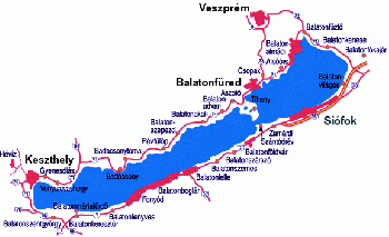
Balaton Cruising Guide
From CruisersWiki
(→Hydrology: some details added) |
(typo) |
||
| Line 15: | Line 15: | ||
==Background== | ==Background== | ||
| - | Lake Balaton is the largest lake in Central Europe. It is in the transdanubian | + | Lake Balaton is the largest lake in Central Europe. It is in the transdanubian region of Hungary. As Hungary is a landlocked country, it is also called "Hungarian Sea". Its hungarian nickname is "Balcsi". German name is "Plattensee". |
You can find the factual data in [http://en.wikipedia.org/wiki/Lake_Balaton Wikipedia's Lake Balaton article], so let's get down to the real background: | You can find the factual data in [http://en.wikipedia.org/wiki/Lake_Balaton Wikipedia's Lake Balaton article], so let's get down to the real background: | ||
| Line 21: | Line 21: | ||
Lake Balaton was also the meeting point for german families divided by the iron courtain. | Lake Balaton was also the meeting point for german families divided by the iron courtain. | ||
| + | |||
The mountains in the nort shore have a good climate for grape, so there are some very nice wines there. The most famous wine growing region there is [http://en.wikipedia.org/wiki/Badacsony Badacsony]. | The mountains in the nort shore have a good climate for grape, so there are some very nice wines there. The most famous wine growing region there is [http://en.wikipedia.org/wiki/Badacsony Badacsony]. | ||
Revision as of 07:28, 27 September 2009
Lake Balaton (Hungary) Cruising Guide
An online cruising guide for yachts sailing in the lake Balaton.
| | |
| GPS: | 46°49.82′N, 17°44.04′E |
|---|---|
| Gallery: | Photo gallery |
Background
Lake Balaton is the largest lake in Central Europe. It is in the transdanubian region of Hungary. As Hungary is a landlocked country, it is also called "Hungarian Sea". Its hungarian nickname is "Balcsi". German name is "Plattensee". You can find the factual data in Wikipedia's Lake Balaton article, so let's get down to the real background:
It is a famous destination for summer vacation. In fact in the communist era it was the best such destination reacheable for most of the population of the country. Hence it has a nearly mithological role for the middle aged and older generations, commonly associated with summer, happiness, young age and love.
Lake Balaton was also the meeting point for german families divided by the iron courtain.
The mountains in the nort shore have a good climate for grape, so there are some very nice wines there. The most famous wine growing region there is Badacsony.
Hydrology
Balaton is a rift lake. 77 km long, roughly in east-west direction, its maximal width is 14 km. The lake is filled from the Zala river and several streams. Te only outflow is the Sió canal, which is used to keep the level of the lake constant. Sió have water only in "planned shipmove times", one or two times a year. It is the hardest to navigate waterway in Hungary. The lake retention time is 2-3 years.
There is one peninsula in the Northern shore, called Tihany peninsula. It divides the lake to two basins. The narrow between the basins is called "the pipe" ("a cső" in Hungarian).
The north shore is mountaneous, and deepens more quickly than the southern one. There are two under-water dunes in the south shore, which means that some 500m from the coast is recommended if you are not heading to/from a port. The main wind is NW, so surface currents are southbound, and underwater currents are northbound. These are slow ones.
Wind is modulated by the north mountains, so sudden changes in its strength and direction are common. Waves can build quickly in the relatively shallow, low viscosity and warm water. The highest measured waves were 1.82m near the coast and 1.95m in the deeps.The wavelength is tipically 2-12m. Folklore says that every 7th wave is big. Wind can make differences in the water level on the shores in an order of half a meter. When it is from west or east, this can drive noticeable currents in the pipe, sometimes in the order of 2m/sec.
Water quality is a high priority for all responsible for the lake, and it is constantly monitored.
Charts
Submit the chart details that are required for safe navigation.
- Chart Source
- Chart No
- Chart No
Radio Nets
Also see World Cruiser's Nets
Local Weather
Local weather conditions?
Sources for Weather forecasts:
Details?
Islands
List Islands
Marinas, Yacht Clubs & Popular Stopovers
Anchorages
List details of popular anchorages in the lake.
Yacht Repairs and Services
Marine Stores
Submit addresses and contact details of marine related businesses that are of interest to cruisers.
Repairs/Yards
Fuel, Water, & Electricity
- Fuel - fuel notes
- Water - water notes
- Electricity - electricity notes
Tourism and Things to do Ashore
Tourism
List places of interest, tours, etc.
Laundry
Grocery & Supply Stores
Eateries
Internet/WiFi
Available?
Motorbike & Car Rentals
Garbage Disposal
?
Transportation
Transportation (local and/or international)
Cruiser's Friends
Contact details of "Cruiser's Friends" that can be contacted for local information or assistance.
Forum Discussions
List links to discussion threads on the Cruiser Log Forum
External Links
Links to relevant websites.
References & Publications
Publications, Guides, etc.
Last Visited & Details Checked (and updated here)
Date of member's visit to this Port/Stop & this page's details validated:
Personal Notes
Personal experiences?
| |
|---|
| | HOMEPAGE | Wiki Contents | Inland Lakes | Lake Balaton | |
.
