Gulf of Aden
From CruisersWiki
(→Navigation) |
(→Personal Notes) |
||
| Line 106: | Line 106: | ||
Personal experiences? | Personal experiences? | ||
* | * | ||
| - | + | Don't take the waypoints on this page! We stayed close to the coast of Yemen and did fine, see also the chart alsewhere in this forum. | |
| - | + | Fishing nets where no problem, coast guard of Yemen called us twice to check who we where. Aden was good to stock up and tank Diesel. | |
| + | From there some 80 NM to Bab el Mandeb, in between Island and mainland and over to Assab to anchor or head on to Massawa. Recently in Massawa there have been some problems at the anchorage (atempted robbery) but it seems that it is controlled now and you are asked to stay alongside of the cay of the harbour. No diesel available or in limited quantities. Water available through the fire department. | ||
| + | Wonderful place to visit, friendly people and very poor. Bring all your left overs (cloths, food, toys, whatever to anyone you see in need in town or ask for the church to help you distribute it!!) | ||
Revision as of 11:05, 9 September 2008
Contents |
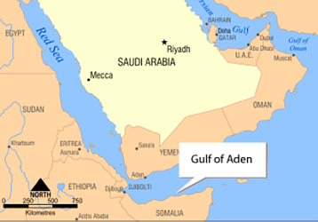
Gulf of Aden
Background
The Gulf of Aden is a vital waterway for shipping, especially for Persian Gulf oil, making it an integral waterway in the world economy. Approximately 11 percent of the world's seaborne petroleum passes through the Gulf of Aden on its way to the Suez Canal or to regional refineries. The main ports along the Gulf are Aden (in Yemen), Zeila, Berbera, and Bosaso in Somalia.
In earlier history, the city of Crater, located just east of the modern city of Aden, was an important port in regional trade. Crater was the principal harbor of the pre-Islamic kingdom of Awsan, and after its annexation by the kingdom of Saba at the end of the 5th century, the port of Crater played a significant role in connecting Africa with Arabia.
Warning: The Gulf of Aden is an area known for acts of piracy, making its waters dangerous for cruising yachts - extreme care must be taken in transit.
Also see the Passage - SE Asia to the Red Sea and the Red Sea
Countries
Radio Nets
Also see Cruiser'a Nets
Charts
List charts required
Navigation issues?
Consider NOT to follow the given wayppoints as given in this section in the middle of the Gulf of Aden as they lead right through the route the pirates take (they come from Somalia) to the area most affected at this moment! (see also the chart http://www.cruiserlog.com/forums/index.php?showtopic=9746) Take a 8 mile of distance of the Yemen and Omani coast (as we did) and keep lights only on when needed and if, use a white light all around as most fisherboats have (besides the many colourful blinkers of all kind of shape and form). The fishing nets that you may encounter are mostly right close to the coast and should not be much of a problem 6 to 8 NM of. Keep radio contact to a minumum and on LOW power. Sail with two or three other yachts and stay in sight of each other. In case of emergency also call Coast Guard of Yemen and Oman, both quite active in the Area.
Furthermore and adding to the content. Take the route close to Yemen and forget Djibouti. It takes you again closer to Somalia than you want and staying close to the Yemen coast of Bab el Mandeb gives more security. Head up North a while and then straight up to Assab where good anchorages can be found. Be aware. Assab is a 'ghosttown' and not much can be bought here. Cross the shipping lane in a 90 degree angle, Yemen's Coast Guard are picky on it!
Weather
General weather conditions?
Sources for weather information:
Passage Details
East-West passage.
- The 1st waypoint is Salalah on the coast of Oman, 16° 57' North x 54° 00' East, where diesel can be purchased and where yachts congregate waiting to make up flotillas before proceeding into the Gulf of Aden.
- Passage:- Salalah to Djibouti
- Leave Salalah - 16° 57' North x 54° 00' East
- 130 nms to
- 1st waypoint - 15° 00' North x 53° 00' East
- 1st waypoint - 15° 00' North x 53° 00' East
- 278 nms to
- 2nd waypoint - 12° 30' North x 49° 00' East
- 2nd waypoint - 12° 30' North x 49° 00' East
- 178 nms to
- 3rd waypoint - 12° 00' North x 46° 00' East
- 3rd waypoint - 12° 00' North x 46° 00' East
- 60nms to
- 4th waypoint - 11° 45' North x 45° 00' East
- 4th waypoint - 11° 45' North x 45° 00' East
- 118 nms to
- 5th waypoint - 11° 40' North x 43° 09' East
- 5th waypoint - 11° 40' North x 43° 09' East
- 7.5 nms to
- 6th waypoint - 11° 37' North x 43° 07' East Djibouti Anchorage.
- Leave Salalah - 16° 57' North x 54° 00' East
Total 771.5 Nautical Miles.
(If you don't want to go to Djibouti turn right for Aden, Yemen: 12°44'45.6" North x 44° 58'13" East before you get to the 4th waypoint.)

Minimum Lights during passage through a 3000 sq. nautical mile area bounded by the coordinates 13° 05' North <> 13° 55' North x 47° 45' East <> 48°45' East. The centre of this "Box" is at 13° 30' North x 48° 15' East, about 80nms South West of Al Mukalla - bearing from Al Mukalla 220° true.
Best is an all round white at cockpit level. ie. fishing boat lighting. (watch out for big ships, then decklevel Nav. Lights to emulate fishing boat)
West-East passage.
(Describe this passage here)
Timing
- East-West passage.
- (Best months for this passage?)
- West-East passage.
- (Best months for this passage?)
Security
At the moment of writing this is one of the most dangerous areas to cross. Please take a moment to check http://www.cruiserlog.com/forums/index.php?showtopic=9746 on this website where a detailed Chart can be found of attacks during the first four months in 2008 as well as a charted map of all incidents in the period of 2005 - 2007. Remember that most of the incidents in 2008 took of from april so suddenly there is a sharp increase in this area. All in all, be careful and prepare well.
Ports, Marinas, Anchorages
References
Publications, guides, etc.
Forum Discussions
Links to discussions on the Cruiser Log Forum
- Piracy in the Gulf of Aden - An excellent graphic from the US Navy (2008)
External Links
Personal Notes
Personal experiences?
Don't take the waypoints on this page! We stayed close to the coast of Yemen and did fine, see also the chart alsewhere in this forum. Fishing nets where no problem, coast guard of Yemen called us twice to check who we where. Aden was good to stock up and tank Diesel. From there some 80 NM to Bab el Mandeb, in between Island and mainland and over to Assab to anchor or head on to Massawa. Recently in Massawa there have been some problems at the anchorage (atempted robbery) but it seems that it is controlled now and you are asked to stay alongside of the cay of the harbour. No diesel available or in limited quantities. Water available through the fire department. Wonderful place to visit, friendly people and very poor. Bring all your left overs (cloths, food, toys, whatever to anyone you see in need in town or ask for the church to help you distribute it!!)
| |
|---|
| | HOMEPAGE | Wiki Contents | Gulf of Aden | |
.


