Ireland
From CruisersWiki
Summercruise (Talk | contribs) (→Ports & Popular Stops) |
Summercruise (Talk | contribs) (→Ports & Popular Stops) |
||
| Line 68: | Line 68: | ||
===Ports & Popular Stops=== | ===Ports & Popular Stops=== | ||
| - | {| class="wikitable" | + | {| class="wikitable" style="font-size:80%" |
| colspan=8 align=center bgcolor=#c0c0c0 style=font-size:120%;font-weight:bold| Southern Ireland (Republic) | | colspan=8 align=center bgcolor=#c0c0c0 style=font-size:120%;font-weight:bold| Southern Ireland (Republic) | ||
|+ | |+ | ||
Revision as of 11:59, 25 July 2009
Ireland - Cruising Guide of Southern
An online cruising guide for sailing around Ireland.
HELP! The IRELAND section is lagging behind in development. |
|---|
| Your assistance is required to develop these pages into a useful resource. Bring out the hidden "cruising guide writer" in you and share your information here (in the true cruising spirit) for all who follow in your wake. |
| Ireland | |
 Ireland | |
| Capital: | Dublin 26 counties - Belfast 6 counties |
|---|---|
| Language: | English, Irish |
| Currency: | Euro/UK£ |
| Time Zone | UTC 0 and +1 |
| Ireland, also known popularly as the Emerald Isle | |
Background
Also see Northern Ireland
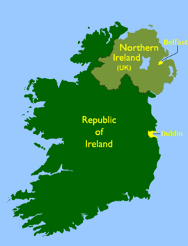
Ireland is the third largest island in Europe, and the twentieth-largest island in the world. It lies to the north-west of continental Europe and is surrounded by hundreds of islands and islets. To the east of Ireland, separated by the Irish Sea, is the island of Great Britain. Politically, the state Ireland (described as the Republic of Ireland in cases of ambiguity) covers five-sixths of the island, with Northern Ireland, part of the United Kingdom, covering the remainder in the north-east.
Describe the cruising/sailing in the region.
Climate & Weather
Climate of Ireland at www.met.ie
Weather Forecasting
Met Éireann, the Irish National Meteorological Service provides a sea area forecast on RTE radio 1, VHF channel 16, Weatherdial, and on their web site at Met.ie - Sea Area Forecast. The Met Eireann Sea Area Map can be found here.
Charts
Admiralty Leisure publish the following leisure chart folios useful for cruising around Ireland. They can be found here.
- 5612 Northern Ireland, Carlingford Lough to Lough Foyle: 1st Edition
- 5621 Ireland - East Coast: 1st Edition
- 5622 Ireland - South Coast: 1st Edition
- 5623 Ireland - South West Coast: 1st Edition
Any navigation notes here.
Local Radio Nets
Also see Cruiser's Nets
Arrival/Departure procedures
Submit any details about advance notification of arrival, etc.
Immigration
Details?
Customs
Details?
Ports & Popular Stops
| Southern Ireland (Republic) | Dublin and East Coast | Waterford to Kinsale | West Cork Roaringwater Bay | Bantry Bay | Kenmare River and Derrynane | Dingle Bay Tralee and Shannon | West Coast | |||||||
|---|---|---|---|---|---|---|---|---|---|---|---|---|---|---|
| Arklow Carlingford Lough Port of Entry Dublin Port of Entry Dun Laoghaire Port of Entry Howth Malahide Wicklow Port of Entry Wexford Port of Entry | Cork Harbour Port of Entry Crosshaven Cobh East Ferry Kilmore Quay Kinsale Port of Entry New Ross Waterford Port of Entry | Baltimore Ballydehob Crookhaven Goleen Rossbrin Schull (Skull) Sherkin | Adrigole Bantry Port of Entry Castletown Beerhaven Glengariff Laurences Cove | Ardgroom Derrynane Port of Entry Kenmare Kilmanacanoge Sneem Westcove | Dingle Harbour Fenit Tralee Port of Entry Valentia Cahersiveen Limerick Port of Entry Kilrush | Galway Port of Entry Sligo Port of Entry Westport Port of Entry | ||||||||
* Red = Pages still to be set up
Offshore Islands
Details?
Health
Submit any health warnings/information and any security details here.
Security
Details?
Transportation
Transportation to mainland or other countries, etc.
References & Publications
The Irish cruising club publishes two pilot guides covering the whole of Ireland:
- East and North Coasts of Ireland Sailing Directions
11th Edition, Published February 2008, Edited by Norman Kean ICC, ISBN No:978 0 9558 199 1 9 - South and West Coasts of Ireland Sailing Directions
12th Edition, Published November 2008, Edited by Norman Kean, ISBN No: 97 0 9558 199 2 6.
Other books include:
- UK and Ireland circumnavigators guide
Written by Samantha Steele, Published October 2008. - Salt and Emerald: A Hesitant Solo Voyage Round Ireland (Paperback)
Written by Alastair Scott (Author), Published July 2008
Tidal Information
- Free tidal information for all Irish ports can be found at Admiralty Easy Tide
Cruiser's Friends
Contact details of "Cruiser's Friends" that can be contacted for local information or assistance.
Forum Discussions
List links to discussion threads on the Cruiser Log Forum
External Links
Personal Notes
Personal experiences?
| |
|---|
| | HOMEPAGE | Wiki Contents | Ireland | |
.
