Port Boise
From CruisersWiki
Peter McHugh (Talk | contribs) (Added anchorage sketch.) |
m (Text replace - "#References & Publications|" to "#References|") |
||
| (24 intermediate revisions not shown) | |||
| Line 1: | Line 1: | ||
| - | + | {{IsPartOf|South Pacific|New Caledonia}} | |
| - | {| | + | {{TOC block}} |
| - | | | + | |
| - | + | ||
| - | + | ||
| - | + | ||
| - | + | ||
| - | + | ||
| - | + | ||
| - | + | ||
| - | + | ||
| - | + | ||
| - | + | ||
| - | + | ||
| - | + | ||
| - | + | ||
| - | + | ||
| - | + | ||
| + | {{Infobox | ||
| + | | lat= -22.35019 | ||
| + | | lon=166.9610 | ||
| + | | portofentry= | ||
| + | | zoom= 15 | ||
| + | | image= Port_Boise_Beach.jpg | ||
| + | | imagetext= Port Boise Beach' | ||
| + | | notes= <googlemap lat="-22.348726" lon="166.965237" zoom="14" width="352"></googlemap> | ||
| + | | news= | ||
| + | }} | ||
Port Boise is a sheltered bay in the SE corner of New Caledonia, 5 nm from Havannah Passe. It offers good anchorage, an opportunity to explore ashore and good reefs to explore. There is a resort on the NE corner of the bay, but the rest of the bay is very undeveloped. The reef at the entrance offers good snorkeling opportunities. | Port Boise is a sheltered bay in the SE corner of New Caledonia, 5 nm from Havannah Passe. It offers good anchorage, an opportunity to explore ashore and good reefs to explore. There is a resort on the NE corner of the bay, but the rest of the bay is very undeveloped. The reef at the entrance offers good snorkeling opportunities. | ||
| Line 23: | Line 17: | ||
Pilot boats waiting for ships to enter Havannah Passe moor in Port Boise. | Pilot boats waiting for ships to enter Havannah Passe moor in Port Boise. | ||
| - | + | ||
| - | + | ||
Port Boise is 5 miles west of Havannah Passe and is an ideal spot to wait for suitable tide or weather to exit the Passe. The lights at the entrance to Port Boise, combined with the Havannah lead lights, make a night departure through the Passe an option if this suits tides, weather or planned trip times. | Port Boise is 5 miles west of Havannah Passe and is an ideal spot to wait for suitable tide or weather to exit the Passe. The lights at the entrance to Port Boise, combined with the Havannah lead lights, make a night departure through the Passe an option if this suits tides, weather or planned trip times. | ||
The next anchorage to the east of Port Boise is Port de [[Goro]].It is 2.5 nm to the entrance. While Port de [[Goro]] is closer to Havannah than Port Boise, night navigation from Goro would be more difficult, so, at least at night, Boise is the better jumping off point. | The next anchorage to the east of Port Boise is Port de [[Goro]].It is 2.5 nm to the entrance. While Port de [[Goro]] is closer to Havannah than Port Boise, night navigation from Goro would be more difficult, so, at least at night, Boise is the better jumping off point. | ||
| - | To the west the entrance to [[Baie de Prony]] is 5.5 miles away. The only hazard in this short trip is the well marked Recif Ioro. Note when entering [[Baie de Prony]] from this direction that the Recif de Prony extends over half a mile from the eastern point. | + | To the west the entrance to [[Baie de Prony]] is 5.5 miles away. The only hazard in this short trip is the well marked Recif Ioro. Note when entering [[Baie de Prony]] from this direction that the Recif de Prony extends over half a mile from the eastern point. The reef is well marked. |
| + | |||
| + | |||
| + | ==Charts== | ||
| + | ; {{MagentaText|Source}} | ||
| + | : {{MagentaText|Chart Number - Chart Name}} | ||
| + | : {{MagentaText|Chart Number - Chart Name}} | ||
| + | ; {{MagentaText|Source}} | ||
| + | : {{MagentaText|Chart Number - Chart Name}} | ||
| + | : | ||
| + | |||
| + | ==Weather== | ||
| + | {{Green|Give local weather conditions or refer to another page (a region or island group) that covers these conditions.}} | ||
| - | + | ||
| - | + | Sources for Weather forecasts: | |
Local forecasts are, of course, in French, but non-French speakers should find them relatively easy to understand. A very useful vocabulary can be found at [http://weather.mailasail.com/Franks-Weather/French-Marine-Weather-Terms How to Understand French Weather Forecasts for Sailors]. | Local forecasts are, of course, in French, but non-French speakers should find them relatively easy to understand. A very useful vocabulary can be found at [http://weather.mailasail.com/Franks-Weather/French-Marine-Weather-Terms How to Understand French Weather Forecasts for Sailors]. | ||
| Line 50: | Line 55: | ||
* Maré: VHF 87 | * Maré: VHF 87 | ||
| - | == | + | ==Passages== |
| - | + | {{Green|List popular passages/routes, timing, etc.}} | |
| - | + | * | |
| - | + | * | |
| - | + | ||
| - | == | + | ==Communication== |
* | * | ||
''Also see [[HF_Radio|World Cruiser's Nets]]'' | ''Also see [[HF_Radio|World Cruiser's Nets]]'' | ||
| - | == | + | ==Navigation== |
| - | [[Image:Port_Boise_Leads.jpg|345px|thumb|right|'''Port Boise Leads''' | + | [[Image:Port_Boise_Leads.jpg|345px|thumb|right|'''Port Boise Leads''']] |
| - | + | [[Image:Port_Boise_Entrance.jpg|345px|thumb|right|'''Port Boise Entrance''']] | |
Port Boise is a short sail from either Port de [[Goro]] or from [[Baie de Prony]]. | Port Boise is a short sail from either Port de [[Goro]] or from [[Baie de Prony]]. | ||
| - | |||
| - | |||
The entrance to Port Boise is adequately wide, marked on both sides and there is a clearly visible set of leads. The navigation markers on the entrance are lit, which could facilitate a night departure from the bay if this was desired. | The entrance to Port Boise is adequately wide, marked on both sides and there is a clearly visible set of leads. The navigation markers on the entrance are lit, which could facilitate a night departure from the bay if this was desired. | ||
| + | ==Entrance== | ||
| + | You must clear Customs at [[Noumea]] before proceeding elsewhere in New Caledonia. While it might be tempting to stop in Port Boise on arrival through Havannah, this is illegal. The track to Noumea is well lit and carrying on after dark presents few problems. | ||
| - | == | + | ==Berthing== |
| - | + | * | |
| - | + | ||
| - | + | ||
===Marinas & Yacht Clubs=== | ===Marinas & Yacht Clubs=== | ||
* None | * None | ||
| - | + | ==Anchorages== | |
| - | [[Image:Port Boise Anchorage Sketch.JPG| | + | [[Image:Port Boise Anchorage Sketch.JPG|345px|thumb|right|'''Port Boise Anchorage''']] |
| - | [[Image:Port_Boise_Anchorage.jpg| | + | [[Image:Port_Boise_Anchorage.jpg|345px|thumb|right|'''View from the SW Anchorage''']] |
While Port Boise is a wide bay, the mouth of the bay is closed off and sheltered by a shallow reef. The entrance is relatively narrow and does not let significant swell enter the bay. | While Port Boise is a wide bay, the mouth of the bay is closed off and sheltered by a shallow reef. The entrance is relatively narrow and does not let significant swell enter the bay. | ||
| Line 88: | Line 90: | ||
Note that a shoal extends a considerable distance out from the area in front of the leads. The edge of this shoal is denoted by a green buoy. | Note that a shoal extends a considerable distance out from the area in front of the leads. The edge of this shoal is denoted by a green buoy. | ||
| - | |||
==Yacht Repairs and Services== | ==Yacht Repairs and Services== | ||
| Line 108: | Line 109: | ||
==Things to do Ashore== | ==Things to do Ashore== | ||
====Tourism==== | ====Tourism==== | ||
| - | |||
* The red sand beach in the SW corner of the bay has a number of tracks leading off it. At the southern end of the beach is a well marked track which climbs up into the bush above the bay and provides an opportunity to explore the local area. It eventually leads to what appears to be an abandoned village development site. At that site is the grave of Chief Charles Attiti, who is mentioned in the Cruising Guide to New Caledonia. | * The red sand beach in the SW corner of the bay has a number of tracks leading off it. At the southern end of the beach is a well marked track which climbs up into the bush above the bay and provides an opportunity to explore the local area. It eventually leads to what appears to be an abandoned village development site. At that site is the grave of Chief Charles Attiti, who is mentioned in the Cruising Guide to New Caledonia. | ||
* There is a resort on the northern side of the bay. | * There is a resort on the northern side of the bay. | ||
| Line 135: | Line 135: | ||
* | * | ||
| - | == | + | ==Friends== |
| - | + | ||
| - | + | ||
| - | + | ||
| - | + | ||
Contact details of "Cruiser's Friends" that can be contacted for local information or assistance. | Contact details of "Cruiser's Friends" that can be contacted for local information or assistance. | ||
* | * | ||
| - | == | + | ==Forums== |
List links to discussion threads on [[Cruising Forums|partnering forums]]. (''see link for requirements'') | List links to discussion threads on [[Cruising Forums|partnering forums]]. (''see link for requirements'') | ||
* | * | ||
| - | == | + | ==Links== |
| - | + | {Green|List links external to the wiki such as in [http://en.wikipedia.org/wiki/Wikipaedia Wikipedia] & [http://en.wikivoyage.org/wiki/Main_Page Wikivoyage].}} | |
| - | + | ||
| - | + | ||
| - | + | ||
| - | + | ||
| - | + | ||
| - | + | {{Green|For Wikipedia you can use the [[Template:Wikipedia|Wikipedia template]] & for the Wikivoyage the [[Template:Wikivoyage|Wikivoyage template]].}} | |
| - | + | * | |
* | * | ||
| - | |||
| - | |||
| - | |||
| + | ==References== | ||
| + | ''See [[New Caledonia#References|New Caledonia]]''. | ||
| + | {{Comments}} | ||
| + | * | ||
| + | {{Verified by}} | ||
| + | * August 2010 - [[User:Peter McHugh|Pedro]] | ||
| - | |||
| - | |||
| - | |||
| - | |||
| - | |||
| - | |||
| - | |||
| - | |||
| - | + | {{page useable}} | |
| - | { | + | |
| - | + | ||
| - | + | ||
| - | + | ||
| - | + | ||
| + | {{Contributors|[[User:Lighthouse|Lighthouse]], [[User:Peter McHugh|Pedro]]}} | ||
[[Category:Ports - New Caledonia]] | [[Category:Ports - New Caledonia]] | ||
Latest revision as of 07:55, 21 August 2018
| Port Boise
| |
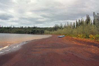
Port Boise is a sheltered bay in the SE corner of New Caledonia, 5 nm from Havannah Passe. It offers good anchorage, an opportunity to explore ashore and good reefs to explore. There is a resort on the NE corner of the bay, but the rest of the bay is very undeveloped. The reef at the entrance offers good snorkeling opportunities.
It provides a sheltered anchorage close to Havannah Passe for vessels planning to head to either the Loyalty Islands or further afield, but requiring a spot to wait for suitable departure conditions.
Pilot boats waiting for ships to enter Havannah Passe moor in Port Boise.
Port Boise is 5 miles west of Havannah Passe and is an ideal spot to wait for suitable tide or weather to exit the Passe. The lights at the entrance to Port Boise, combined with the Havannah lead lights, make a night departure through the Passe an option if this suits tides, weather or planned trip times.
The next anchorage to the east of Port Boise is Port de Goro.It is 2.5 nm to the entrance. While Port de Goro is closer to Havannah than Port Boise, night navigation from Goro would be more difficult, so, at least at night, Boise is the better jumping off point.
To the west the entrance to Baie de Prony is 5.5 miles away. The only hazard in this short trip is the well marked Recif Ioro. Note when entering Baie de Prony from this direction that the Recif de Prony extends over half a mile from the eastern point. The reef is well marked.
Charts
- Source
- Chart Number - Chart Name
- Chart Number - Chart Name
- Source
- Chart Number - Chart Name
Weather
Give local weather conditions or refer to another page (a region or island group) that covers these conditions.
Sources for Weather forecasts:
Local forecasts are, of course, in French, but non-French speakers should find them relatively easy to understand. A very useful vocabulary can be found at How to Understand French Weather Forecasts for Sailors.
The main source of weather information for the area around New Caledonia is Meteo France Nouvelle-Calédonie. The marine section provides a 6 day forecast for the whole region, with details for each of the passes through the barrier reef.
Nouméa radio broadcasts the weather report in French on VHF 16, everyday at 6:30, 9:30, 15:15, 18:30.
There is a set of repeater channels allowing receipt of weather info anywhere in the country:
- Nouméa area: VHF 26
- Southern portion of the Grande Terre: VHF 28
- Isle of Pines and the Southern Lagoon: VHF 25
- Grande Terre North West coast: VHF 25
- Northern portion of Grande Terre: VHF 24
- Ouvea: VHF 23
- Lifou: VHF 26
- Maré: VHF 87
Passages
List popular passages/routes, timing, etc.
Communication
Also see World Cruiser's Nets
Port Boise is a short sail from either Port de Goro or from Baie de Prony.
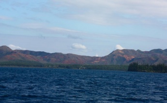
The entrance to Port Boise is adequately wide, marked on both sides and there is a clearly visible set of leads. The navigation markers on the entrance are lit, which could facilitate a night departure from the bay if this was desired.
Entrance
You must clear Customs at Noumea before proceeding elsewhere in New Caledonia. While it might be tempting to stop in Port Boise on arrival through Havannah, this is illegal. The track to Noumea is well lit and carrying on after dark presents few problems.
Berthing
Marinas & Yacht Clubs
- None
Anchorages
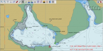
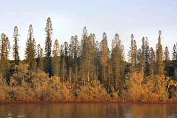
While Port Boise is a wide bay, the mouth of the bay is closed off and sheltered by a shallow reef. The entrance is relatively narrow and does not let significant swell enter the bay.
- The SW corner of the bay, off a red sand beach, is probably the most sheltered spot in the bay.
- The NW corner of the bay also offers a sheltered inlet.
Note that a shoal extends a considerable distance out from the area in front of the leads. The edge of this shoal is denoted by a green buoy.
Yacht Repairs and Services
Marine Stores
Submit addresses and contact details of marine related businesses that are of interest to cruisers.
- None
Repairs/Yards
- None
Fuel, Water, & Electricity
- Fuel
- None
- Water
- None
- Electricity
- None
Things to do Ashore
Tourism
- The red sand beach in the SW corner of the bay has a number of tracks leading off it. At the southern end of the beach is a well marked track which climbs up into the bush above the bay and provides an opportunity to explore the local area. It eventually leads to what appears to be an abandoned village development site. At that site is the grave of Chief Charles Attiti, who is mentioned in the Cruising Guide to New Caledonia.
- There is a resort on the northern side of the bay.
- There is good snorkeling over the shallow reef near the entrance to the bay.
Grocery & Supply Stores
None
Eateries
Maybe at the resort.
Internet/WiFi
Available?
Laundry
None.
Motorbike & Car Rentals
None.
Garbage Disposal
None.
Transportation
Transportation (local and/or international)
Friends
Contact details of "Cruiser's Friends" that can be contacted for local information or assistance.
Forums
List links to discussion threads on partnering forums. (see link for requirements)
Links
{Green|List links external to the wiki such as in Wikipedia & Wikivoyage.}}
For Wikipedia you can use the Wikipedia template & for the Wikivoyage the Wikivoyage template.
References
See New Caledonia.
Comments
We welcome users' contributions to the Wiki. Please click on Comments to view other users' comments, add your own personal experiences or recommend any changes to this page following your visit.
Verified by
Date of member's last visit to Port Boise and this page's details validated:
- August 2010 - Pedro
| This is a usable page of the cruising guide. However, please contribute if you can to help it grow further. Click on Comments to add your personal notes on this page or to discuss its contents. Alternatively, if you feel confident to edit the page, click on the edit tab at the top and enter your changes directly. |
| |
|---|
|
Names: Lighthouse, Pedro |


