Santa Catalina Island
From CruisersWiki
Santa Catalina Island
Background
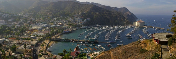
Santa Catalina Island, often called Catalina Island, or just Catalina, is a rocky island off the coast of the U.S. state of California. The island is 22 miles (35 km) long and 8 miles (13 km) across at its greatest width. The island is located about 22 miles (35 km) south-southwest of Los Angeles, California. The highest point on the island is 2,097 feet (639 m) Mt. Orizaba, at 33°22′29.7″N 118°25′11.6″W. Additional information about the island's history is best represented here.
Charts
NOAA Chart 18757 Scale: 1:40000
Size: 36.0" x 52.0"
NTM: http://www.nga.mil/maritime
LNM Notice/Date: 2212 2012-05-29
LNM: http://ocsdata.ncd.noaa.gov/nm
All official nautical paper charts produced by NOAA's Office of Coast Survey (OCS) are available in computerized format. An interactive Chart Catalog is available on the NOAA site as well.
Radio Nets
Submit details of local radio Nets.
Approach
Catalina is an easy day passage from ports in Los Angeles, Orange, and San Diego counties. It is a popular boating destination for that reason. Except during winter storms, times of fog, or high winds, the passage is straighforward from the mainland. It is 18.5 miles by 7 miles wide. The rugged hills can be seen from a long distance on clear days. Highest elevation is 2,125 ft. From the North, Catalina is more difficult to see on a hazy day. It is likely that you'll be within 5 miles of the West End before seeing the island and then shortly you will see Eagle Rock (with a white top). The West End Light The West End Light ![]() 33°28.7′N, 118°36.3′W is a white structure which is a useful daytime landmark but has been noted to be hard to see at night. From the South, there is a notable rock quarry about 1.5 miles E of Avalon which will be visible before any of the buildings of the town are sighted. Once close inshore, you can follow the shoreline from a distance of 0.5-1.0 miles off as the dangerous rocks are well marked on the charts or easy to see.
33°28.7′N, 118°36.3′W is a white structure which is a useful daytime landmark but has been noted to be hard to see at night. From the South, there is a notable rock quarry about 1.5 miles E of Avalon which will be visible before any of the buildings of the town are sighted. Once close inshore, you can follow the shoreline from a distance of 0.5-1.0 miles off as the dangerous rocks are well marked on the charts or easy to see.
Check-in facilities
Visitors from outside the USA must clear customs in San Diego. There are no customs facilities here.
Ports and Popular Stops
There are moorings at Avalon Bay, the Two harbors of Isthmus Cove and Catalina Harbor. There is a US Post Office at Two Harbors.
Marinas & Yacht Clubs
Catalina is home to two yacht clubs: Catalina Island Yacht Club is headquartered in Avalon Bay and Isthmus Yacht Club is headquartered in the 1864 Union Army Barracks at Two Harbors. Many mainland yacht clubs maintain Catalina stations. Moonstone is another private cove operated by the Newport Harbor Yacht Club of Newport Beach, California. Just west of Moonstone Cove is Whites Landing. Whites Landing is home to two yacht club camps, Balboa Yacht Club to the west, and San Diego Yacht Club to the east. In the center of the large cove on a 14-acre (57,000 m2) parcel is a private camp and retreat center called the Catalina Experience. The Catalina Experience hosts numerous youth camps, family camps, group retreats and outdoor education programs. Just west of Two Harbors is Fourth of July Yacht Club located in Fourth of July Cove. For additional information about visiting Catalina by boat, you may contact the Two Harbors Visitors Center at 888.510.7979 or visit the Catalina Island Website
Anchorages
Many of the good anchorages around the island has been filled with a tight series of two point (bow and stern) private moorings which may be rented on a first come first served basis. Anchoring among the mooring fields is not permitted. If you choose to anchor in/near one of the popular mooring fields, you will do so in (50 ft to 120 ft) deep waters beyond the moorings and often beyond the protection of the natural anchorage and should be prepared to move during the night should winds arise.
Health & Security
The Two Harbors Harbor Department may be reached on VHF Channel 16, then working channel 9 or via phone 310.510.1535; Avalon Sheriff's Station phone is 310.510.0174; Local Weather information phone is 213.554.1212;
Tourism & things to do ashore
Kayaking is a popular activity around the island. There are kayaking tours available. Catalina is also popular with SCUBA divers. Water temperatures range from 63 to 73 degrees F in the summer and 53 to 60 degrees F in the winter. The water is very clear in the winter. If you do not have gear, there are full service diving facilities located in Avalon and Two Harbors all of which have day-charter boats. You can rent or buy equipment for diving on the island. Eagle Reef is on the NE shore of the island W of the Isthmus. It is a large area of pinnacles with the highest within 4 feet of the water's surface. You can see yellowtail, white sea bass, and calico here. Lover's Cove Marine Preserve is set aside for beach-diving and snorkeling. SCUBA diving is not permitted in this area. Fishing is also a popular activity at Santa Catalina island. The fish close near shore include sea bass, rock cod, button perch, sand dabs, and sheepshead. People who visit Catalina enjoy hiking and mountain biking as there is a network of well developed and undeveloped trails on the island. A free hiking permit is available at the Department of Parks and Recreation in Avalon and in Two Harbors. Beach camping is permissible on the island near Parson's Landing and Ripper's Cove. Advanced reservations required 310.510.2800 for information. Avalon Shore Boat: 310.510.2683 or channel 9 Catalina Taxi: 310.510.0025
Marine stores
Unknown
Routes to/from
Provisioning may be done on the mainland at nearby Newport Beach and inland Santa Ana. When visiting the California Channel Islands, it is a nice day sail from the numerous anchorages of Santa Cruz and Santa Rosa Islands to reach the anchorages of Santa Catalina Island. Sailors coming from the South, typically leave, motoring, from San Diego in the night as the prevailing NW winds run directly on the nose for that passage.
References & Publications
- The Cruising Guide to Central and Southern California by Brian Fagan International Marine Press ISBN 0-07-137464-7
Cruiser's Friends
Contact details of "Cruiser's Friends" that can be contacted for local information or assistance.
Forum Discussions
List links to discussion threads on partnering forums. (see link for requirements)
- http://www.cruiserlog.com/forums/f12/another-wonderful-weekend-of-sailing-and-diving-2112.html
- http://www.cruiserlog.com/forums/f16/seaweed-biodiesel-2751.html
External Links
Links to relevant websites.
- Catalina Island
- “A California Verde Antique Quarry,” 1899 Scientific American article (PDF) on Stone Quarries and Beyond. (Includes photographs and history about the American Indian olla or mortar quarry and the later serpentine quarry at Pott’s Valley, later known as Empire Landing, Santa Catalina Island.)
- Catalina Island Views, California, ca. 1900-1909, The Bancroft Library
Personal Notes
Back to the Channel Islands , and, Visit to the Isthmus 2010 accounting of anchoring in 90 ft depth outside the mooring field at the Isthmus in October 2010.
Template:Guide1
|
|---|
|
Names: Redbopeep, Haiqu Lighthouse |
|
|
|---|
| | HOMEPAGE | Wiki Contents | East Pacific | United States | Los Angeles | Edit/remove | |

