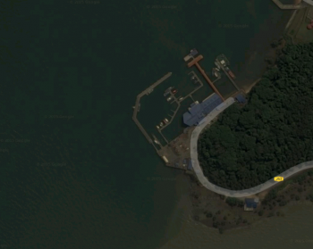
Tanjung Pengelih
From CruisersWiki
| Tanjung Pengelih Port of Entry
| |
| Radio | VHF channel ? |
|---|---|
| Phone | ? |
| Berths | 0 |
| Max. length | ? |
| Max. draft | 3m |
| Fuel | none |
| Water | none |
| Electricity | none |
| Toilets | available |
| Showers | No |
| Laundry | No |
| Internet | No |
| Cable TV | No |
| Hours | 6am to 6pm, 7 days |
| More notes about the marina | |
Tanjung Pengelih is a good stop for Port, Customs, Immigration in one place. Located at the eastern entrance to the Johor Straits it is the best place to do customs and immigration clearance before continuing to Johor Bahru.
Communication
Radio is not monitored, there is no need to radio on approach.
The most important thing is not to spend any time loitering in the channel separation scheme in the Singapore Strait. The best way to do that is to avoid CSS altogether.
Sail to a point around 1 27.075 N, 104 27.137E. You will see that there is a lighthouse just north of that point, and there are many shoals also marked on the charts. You should also see the CSS marked on the chart, it runs westwards on the north side and eastward on the south side. You can avoid the CSS altogether by running between the shoals and the northern lane of the CSS. The CSS at that point will be full of ships anyway, your AIS will go off like a frog in a sock. Note that if you are venturing into Singapore waters you must have an AIS transponder switched on, this is not a requirement if you are remaining entirely in Malaysian waters.
In any case, going on the northern side keeps you in Malaysian waters. Remember you should have the Malaysian flag and the Q flag up at this point.
Pengerang is marked as a town on the Navionics charts, on the south coast of the Johor peninsula, which is the land which by now should be on your starboard side.
Once you are around 1 18.942N 104 9.187E you will diverge away from the CSS, turning slightly north to head to the north side of Pulau Tekong. This is a large and partially reclaimed island that's at the mouth of the Johor Strait, it's marked but not named on the C-MAP chart. Easy to spot, it's big and teardrop-shaped.
The Malaysia/Singapore border runs actually between this island and the Pengerang coast and so you need to stay to starboard of the centre line of the strait from that point. Not too close to shore because there are shoals and fishing stakes.
There is a quarantine anchorage marked on the Navionics charts at that point. Ignore that.
Tanjung Pengileh is actually the westernmost end of that point, at about 1 22.418N, 104 5.362E. You won't see much until you round the tip of the southwestern corner of that peninsula, which forms an acute angle, as if it's pointing at the southern end of that teardrop island (actually the part that's marked as an island on C-MAP charts but is still underwater in real life).
Once you round that tip, Tanjung Pengileh is the first thing you see. There is an impressive looking floating breakwater and a number of official-looking (and some unofficial looking) boats tied up in a deceptively pleasant-looking marina.
DON'T GO INSIDE THIS MARINA, it's for official use only and only about a metre deep. You can tie up at the breakwater on the outside. Be careful of the southern part of this breakwater, the pylons are probably too close together to make tying up possible. From there you'll see the marina and the blue-roofed customs/immigration/ferry terminal building.
There are bumboats (ferries that carry about 8-12 passengers) running continually between here and Singapore, sometimes at high speed so keep a watch out.
If currents are too strong to enter, anchor to the South and dinghy in. Stay away from Navy pier further North.
Berthing
It is permissible to tie up to the outside of any of the piers. Do not enter into the marina itself, this is now reserved for official usage. Long stays are not permitted but the officials here appear to be unconcerned by vessels tying up overnight or for slightly longer periods while waiting for clearance or tides in the Johor Straits.
Be aware that several facilities (e.g. Senibong Cove) in the Johor Straits cannot be entered at low tide, and so waiting here for tides is often judicious.
Facilities
There are no facilities here other than customs and immigration clearance.
Location
The port is near the town of Pengerang but leaving a vessel here unattended while taking a trip there is probably inadvisable.
Transportation
There are some taxis nearby. Some of the taxi drivers speak English, most do not.
Price
Provide price information. If possible add a link to the marina's pricing page.)
For the latest prices see [XXX Price Listing].
Comments
We welcome users' contributions to the Wiki. Please click on Comments to view other users' comments, add your own personal experiences or recommend any changes to this page following your visit.
Verified by
Date of member's last visit to Tanjung Pengelih and this page's details validated:
- Delatbabel -- October 2015.
| This is a usable page of the cruising guide. However, please contribute if you can to help it grow further. Click on Comments to add your personal notes on this page or to discuss its contents. Alternatively, if you feel confident to edit the page, click on the edit tab at the top and enter your changes directly. |
| |
|---|
|
Names: Delatbabel |
