Bozcaada
From CruisersWiki
Bozcaada
| | Coords: 39°50.1′N, 26°04.6′E Chartlet: Chartlet Gallery: Photos |
Background
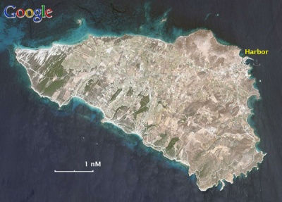
Bozcaada the Greek Tenedos (Τένεδος) is a small island with a long history. In ancient times it was associated with Apollo and the Trojan War, when the Greeks used it as base. It was here that they retired to after leaving the Trojan horse as a "gift." During the Byzantine times it was used as a grain depot so that large ships could unload their grain and not go to Constantinople through the Dardanelles.
The large castle that dominates the small town was built by the Genoese during the end of the Byzantine era. During modern times it was inhabited by Greeks and it was part of Greece until 1923 when it was ceded to Turkey (together with Ibroz or Imvros) under the terms of a peace treaty. The Greek inhabitants were not exchanged (as was the case elsewhere) but were allowed to stay and operate their schools and churches. Over the years most Greeks have left. The island is well known for its vineyards and production of wine.
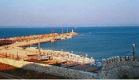
The island was a military zone and visits by foreign yachts were discouraged until recently were discouraged. Now yachts are invited. The harbor has very clear and attractive water. The town is slowly being restored, and is fashionable with wealthy people from Istanbul. There are many old interesting houses and buildings.
Charts
- BA
- 1086 Srimonikos kólpos to Edremit Körfezi
- Imray-Tetra
- G2 Aegean Sea (North)
- NIMA
- 54360 Thessaloniki to Canakkale Bogazi Dardanelles
- 54369 Approaches to Canakkale Bogazi
- Turkey
- 2136 Bozcaada
- Greek
- 32 Thrakiko Sea
- Greek 322 Limnos & Ay. Efstratios
Radio Nets
Also see Cruiser's Nets
Submit details of local radio Nets.
The approaches to Bozcaada are straightforward, no dangers.
Check-in facilities
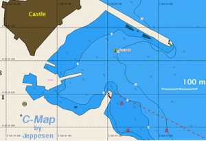
There is only one harbor (GPS: 39°50.1′N, 26°04.6′E).
Anchor moor to the north mole.
Routes/Passages To/From
Popular passages/routes, timing, etc.
Tourism & things to do ashore
The large Genoese castle, which also has a small museum, and the narrow picturesque streets.
Fuel, Water, & Electricity
- Fuel - N/A
- Water - There is an outlet on the quay.
- Electricity - N/A
Laundry
N/A.
Grocery & Supply Stores
- Limited stores
Eateries
- There are several good restaurants along the fishing harbor
Internet/WiFi
N/A
Motorbike & Car Rentals
N/A
Marine stores
None.
Repairs
N/A.
Transportation
Ferries to Çanakkale.
References & Publications
See Turkey.
Cruiser's Friends
Contact details of "Cruiser's Friends" that can be contacted for local information or assistance.
Forum Discussions
List links to discussion threads on the Cruiser Log Forum
External Links
- Bozcaada (Wikipedia)
Personal Notes
- I loved this out of the main stream island. Wonderful walks. The harbor is so clean you can jump into the cool water right from your boat. --Istioploos 16:42, 25 June 2008 (MDT)
- The castle is a most impressive example of Venetian military architecture, subsequently improved by the Ottomans. (Athene of Lymington May 2008)
Last Visited & Details Checked (and updated here)
Date of member's visit to this Port/Stop & this page's details validated:
- June 1999 --Istioploos 16:42, 25 June 2008 (MDT)
- May 2008 -- Athene of Lymington
| |
|---|
| | HOMEPAGE | Wiki Contents | Mediterranean | Aegean Sea | Turkey | Bozcaada | |
.


