Cayman
From CruisersWiki
m (Text replace - "Caribbean Cruising Guide|Caribbean" to "Caribbean") |
(→Local Radio Nets) |
||
| Line 58: | Line 58: | ||
===Local Radio Nets=== | ===Local Radio Nets=== | ||
| - | ''Also see [[ | + | ''Also see [[World MM Nets|World Cruiser's Nets]]'' |
| - | * | + | * |
===Arrival/Departure procedures=== | ===Arrival/Departure procedures=== | ||
Revision as of 10:11, 13 June 2011
CAYMAN ISLANDS CRUISING GUIDE
An online cruising guide for sailing around the Cayman Islands.
| Cayman Islands | |
 Cayman Islands | |
 Flag | |
| Capital: | George Town |
|---|---|
| Language: | English |
| Currency: | Cayman Islands Dollar (KYD) |
| Timezone: | UTC-5 |
| More notes about the country | |
| | |
| Content - news items, etc. | |
Overview
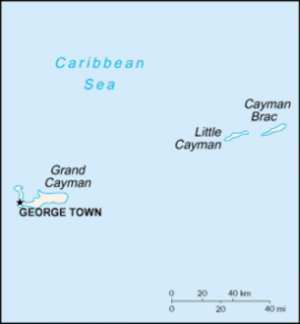
The Cayman Islands are a British overseas territory located in the western Caribbean Sea, comprising the islands of Grand Cayman, Cayman Brac, and Little Cayman. It is a major financial centre in the Caribbean.
The Cayman Islands are located in the western Caribbean Sea. They are the peaks of a massive underwater ridge, known as the Cayman Trench, standing 8,000 feet (2,400 m) from the sea floor, which barely exceeds the surface. The islands lie in the centre of the Caribbean south of Cuba and West of Jamaica. They are situated about 400 miles (650 km) south of Miami, 180 miles (300 km) south of Cuba, and 195 miles (315 km) northwest of Jamaica. Grand Cayman is by far the biggest, with an area of 76 square miles (197 km²). The two "Sister Islands" of Cayman Brac and Little Cayman are located about 80 miles (130 km) east of Grand Cayman and have areas of 14 square miles (36 km²) and 10 square miles (25.9 km²) respectively.
All three islands were formed by large coral heads covering submerged ice age peaks of western extensions of the Cuban Sierra Maestra range and are mostly flat. One notable exception to this is The Bluff on Cayman Brac's eastern part, which rises to 140 feet (42.6 m) above sea level, the highest point on the island.
Cruising the region
Climate & Weather
Submit the climate & general weather details here.
Sources of weather forecasting here.
Charts
Submit details of the charts required for safe navigation of the area.
Any navigation notes here.
Local Radio Nets
Also see World Cruiser's Nets
Arrival/Departure procedures
Submit any details about advance notification of arrival, etc.
Immigration
Details?
Customs
Details?
Ports & Popular Stops
See Islands
Islands in the Group
Health
Submit any health warnings/information and any security details here.
Security
Details?
Transportation
Transportation to mainland or other countries, etc.
References & Publications
Books, Guides, etc.
References & Publications
Publications, Guides, etc.
Cruiser's Friends
Contact details of "Cruiser's Friends" that can be contacted for local information or assistance.
Forum Discussions
List links to discussion threads on partnering forums. (see link for requirements)
External Links
Personal Notes
Personal experiences?
|
|---|
|
Names: |
| |
|---|
| | HOMEPAGE | Wiki Contents | Caribbean | Middle America | Greater Antilles | Cayman Islands | |