Herceg Novi
From CruisersWiki
Istioploos (Talk | contribs) (Chartlet) |
m (Text replace - "#References_.26_Publications|" to "#References|") |
||
| (25 intermediate revisions not shown) | |||
| Line 1: | Line 1: | ||
| + | {{IsPartOf|Mediterranean|Adriatic Sea|Montenegro}} | ||
| + | {{TOC block}} | ||
{{Infobox |42|27.02|N|18|31.93|E| | {{Infobox |42|27.02|N|18|31.93|E| | ||
| - | | | + | | zoom= 17 |
| image= HercegHarbour.jpg | | image= HercegHarbour.jpg | ||
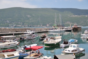
| - | | imagetext= Herceg Novi harbour is crammed with moorings | + | | imagetext= Herceg Novi harbour is crammed with moorings |
| - | + | }} | |
{| class="infobox bordered" style="width: 28em; text-align: right; font-size: 90%;" | {| class="infobox bordered" style="width: 28em; text-align: right; font-size: 90%;" | ||
|- | |- | ||
| Line 10: | Line 12: | ||
Herceg Novi is a small harbour on the N side of the Hercegnovski Zaliv (Bay of Herceg), the first of the three gulfs that form the Gulf of [[Kotor]] in [[Montenegro]]. It lies just over three miles N of the entrance to the Gulf and around 1.5 miles W of [[Zelenika]], the nearest port of entry. The harbour consists of a long breakwater extending WSW from a prominent rock on which sits an imposing Venetian castle. The town's name derives from a 15th century Herzegovinian duke who was responsible for fortifying the town (''herzeg'' = duke). Its harbour can accommodate around 40 yachts of up to 20 metres and provides good shelter in all but strong S or W winds, which raise a considerable swell. | Herceg Novi is a small harbour on the N side of the Hercegnovski Zaliv (Bay of Herceg), the first of the three gulfs that form the Gulf of [[Kotor]] in [[Montenegro]]. It lies just over three miles N of the entrance to the Gulf and around 1.5 miles W of [[Zelenika]], the nearest port of entry. The harbour consists of a long breakwater extending WSW from a prominent rock on which sits an imposing Venetian castle. The town's name derives from a 15th century Herzegovinian duke who was responsible for fortifying the town (''herzeg'' = duke). Its harbour can accommodate around 40 yachts of up to 20 metres and provides good shelter in all but strong S or W winds, which raise a considerable swell. | ||
| - | == | + | ==Charts== |
| + | ''See [[Montenegro#Charts|Montenegro]]''. | ||
| + | |||
| + | ==Weather== | ||
The Gulf of Kotor is surrounded by high mountains, which give protection from strong winds at sea and from swell, which is only experienced in the Bay of Herceg Novi and then only with strong southerlies. However, there can be sudden katabatic winds, especially following spells of very hot weather, which tumble off the mountains at night with considerable force. | The Gulf of Kotor is surrounded by high mountains, which give protection from strong winds at sea and from swell, which is only experienced in the Bay of Herceg Novi and then only with strong southerlies. However, there can be sudden katabatic winds, especially following spells of very hot weather, which tumble off the mountains at night with considerable force. | ||
| - | ''See also [[Montenegro# | + | ''See also [[Montenegro#Weather|Montenegro]]''. |
| - | == | + | ==Passages== |
| - | + | 'See [[Montenegro#Passages|Montenegro]]''. | |
| + | |||
| + | ==Islands== | ||
| + | None. | ||
| - | == | + | ==Communication== |
* ''See [[Montenegro#Radio_Nets|Montenegro]]'' | * ''See [[Montenegro#Radio_Nets|Montenegro]]'' | ||
''Also see [[World MM Nets|World Cruiser's Nets]]''. | ''Also see [[World MM Nets|World Cruiser's Nets]]''. | ||
| - | == | + | ==Navigation== |
There are no dangers in the approach from S, but there are several above-water rocks some 200 metres due E of the end of the harbour breakwater which need to be given a good clearance if approaching from [[Zelenika]] after having cleared in. There are numerous boats on moorings inside the harbour, which restricts space for manoeuvering when mooring on the quay. Herceg Novi can be a test of your boat handling skills if there is any wind blowing. | There are no dangers in the approach from S, but there are several above-water rocks some 200 metres due E of the end of the harbour breakwater which need to be given a good clearance if approaching from [[Zelenika]] after having cleared in. There are numerous boats on moorings inside the harbour, which restricts space for manoeuvering when mooring on the quay. Herceg Novi can be a test of your boat handling skills if there is any wind blowing. | ||
| Line 29: | Line 37: | ||
None. It is necessary to clear in at [[Zelenika]] first if arriving from outside Montenegro. | None. It is necessary to clear in at [[Zelenika]] first if arriving from outside Montenegro. | ||
| - | ==Berthing | + | ==Berthing== |
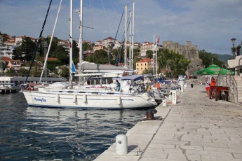
| - | {{Image right|HercegQuay.jpg |The yacht quay | + | {{Image right|HercegQuay.jpg |The yacht quay }} |
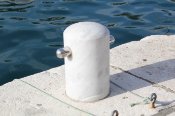
{{Image right|HercegBollard.jpg |The marble and stainless steel bollards are a work of art<br /> ''Click for larger view''}} | {{Image right|HercegBollard.jpg |The marble and stainless steel bollards are a work of art<br /> ''Click for larger view''}} | ||
Visiting yachts moor stern or bows-to using the mooring lines supplied (two per yacht) on the quay inside the breakwater. There is space for around 40 yachts of up to 20 metres. Depths range from 3.0 metres at the inner end to 9.0 metres at the outer end. There is a plentiful supply of stout iron and marble/stainless steel bollards along the quay. There is usually a red-shirted harbour official who will help moor up (and sometimes ask for a tip!). Water and electricity are included in the berthing price. Shelter in the harbour is good in most conditions, but strong southerlies (15-20 knots or above) send in an uncomfortable swell. Also, the harbour is completely open W and very strong winds from that direction would be dangerous. There are no other facilities, although there are toilets at the cafe/bar on the quay which can be used by yacht crews. | Visiting yachts moor stern or bows-to using the mooring lines supplied (two per yacht) on the quay inside the breakwater. There is space for around 40 yachts of up to 20 metres. Depths range from 3.0 metres at the inner end to 9.0 metres at the outer end. There is a plentiful supply of stout iron and marble/stainless steel bollards along the quay. There is usually a red-shirted harbour official who will help moor up (and sometimes ask for a tip!). Water and electricity are included in the berthing price. Shelter in the harbour is good in most conditions, but strong southerlies (15-20 knots or above) send in an uncomfortable swell. Also, the harbour is completely open W and very strong winds from that direction would be dangerous. There are no other facilities, although there are toilets at the cafe/bar on the quay which can be used by yacht crews. | ||
| - | + | ==Anchorages== | |
None. It is not permitted to anchor off the harbour. | None. It is not permitted to anchor off the harbour. | ||
| - | |||
| - | |||
| - | |||
| - | |||
==Yacht Repairs and Services== | ==Yacht Repairs and Services== | ||
| Line 49: | Line 53: | ||
====Fuel, Water, & Electricity==== | ====Fuel, Water, & Electricity==== | ||
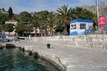
| - | {{Image right|HercegFuel.jpg |The fuel berth has depths of 2.5 metres | + | {{Image right|HercegFuel.jpg |The fuel berth has depths of 2.5 metres }} |
; Fuel | ; Fuel | ||
: At the root of the quay (2.5 metre depths) | : At the root of the quay (2.5 metre depths) | ||
| Line 56: | Line 60: | ||
; Electricity | ; Electricity | ||
: On the quay | : On the quay | ||
| - | |||
==Things to do Ashore== | ==Things to do Ashore== | ||
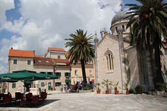
| - | {{Image right|HercegNoviSquare.jpg | The main square of the old town'' | + | {{Image right|HercegNoviSquare.jpg | The main square of the old town'' }} |
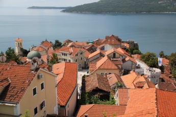
| - | {{Image right|HercegNoviOldTown.jpg |The old town from the castle | + | {{Image right|HercegNoviOldTown.jpg |The old town from the castle }} |
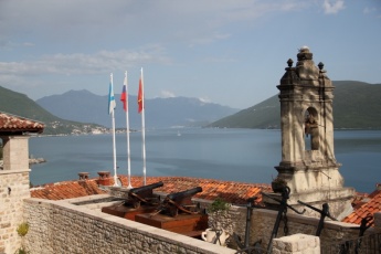
| - | {{Image right|HercegView.jpg |There are magnificent views from the old town | + | {{Image right|HercegView.jpg |There are magnificent views from the old town}} |
====Tourism==== | ====Tourism==== | ||
The Stari Grad (old town) of Herceg Novi, though not as impressive as that of [[Budva]], has a more 'lived-in' feel and, while it's a long, steep climb up from the harbour, the effort is worthwhile. The best entrance is from W up a narrow alley under the arch of a 17 century clock tower that was constructed on top of the original main gate of the town. The alley leads to Trg Herzeg Stjepana (Duke Stefan Square), where there are shady cafes and the elegant 19th century Orthodox church of Archangel Michael, which contains an elaborately carved marble iconostasis. Up another alley to the left is the way to the Kanli-Kula (Bloody Tower), a 15th century fortress used as a prison during the period of Ottoman rule. Back down at the harbour, a long promenade leads W from the harbour along the line of a former railway track, past the old stone-built railway station, now a popular cafe, and through several tunnels as far as the settlement of Igalo. | The Stari Grad (old town) of Herceg Novi, though not as impressive as that of [[Budva]], has a more 'lived-in' feel and, while it's a long, steep climb up from the harbour, the effort is worthwhile. The best entrance is from W up a narrow alley under the arch of a 17 century clock tower that was constructed on top of the original main gate of the town. The alley leads to Trg Herzeg Stjepana (Duke Stefan Square), where there are shady cafes and the elegant 19th century Orthodox church of Archangel Michael, which contains an elaborately carved marble iconostasis. Up another alley to the left is the way to the Kanli-Kula (Bloody Tower), a 15th century fortress used as a prison during the period of Ottoman rule. Back down at the harbour, a long promenade leads W from the harbour along the line of a former railway track, past the old stone-built railway station, now a popular cafe, and through several tunnels as far as the settlement of Igalo. | ||
| Line 91: | Line 94: | ||
* Long-distance buses to Dubrovnik | * Long-distance buses to Dubrovnik | ||
| - | == | + | ==Friends== |
| - | + | ||
| - | + | ||
| - | + | ||
Contact details of "Cruiser's Friends" that can be contacted for local information or assistance. | Contact details of "Cruiser's Friends" that can be contacted for local information or assistance. | ||
* | * | ||
| - | == | + | ==Forums== |
List links to discussion threads on [[Cruising Forums|partnering forums]]. (''see link for requirements'') | List links to discussion threads on [[Cruising Forums|partnering forums]]. (''see link for requirements'') | ||
* | * | ||
| - | == | + | ==Links== |
* {{wikipedia}} | * {{wikipedia}} | ||
| + | * [http://www.porthercegnovi.com/en/ Herceg Novi City Port] | ||
| + | * [http://www.hercegnovi.montenegro.travel/en/ship-7 Nearby ports] at http://www.hercegnovi.montenegro.travel | ||
| - | ==References | + | ==References== |
| - | ''See [[Montenegro# | + | ''See [[Montenegro#References|Montenegro]]''. |
| - | + | {{Comments note}} | |
| - | + | ||
| - | + | ||
| - | + | ||
| - | + | {{Verified by}} | |
| - | + | ||
* May 2014 – [[User:Atheneoflymington|Athene of Lymington]] | * May 2014 – [[User:Atheneoflymington|Athene of Lymington]] | ||
* | * | ||
| Line 124: | Line 123: | ||
{{Contributors|[[User:Lighthouse|Lighthouse]], [[User:Atheneoflymington|Athene of Lymington]]}} | {{Contributors|[[User:Lighthouse|Lighthouse]], [[User:Atheneoflymington|Athene of Lymington]]}} | ||
| - | |||
| - | |||
[[Category:Ports - Montenegro]] | [[Category:Ports - Montenegro]] | ||
Latest revision as of 14:54, 21 August 2018
| Herceg Novi
| |
Herceg Novi is a small harbour on the N side of the Hercegnovski Zaliv (Bay of Herceg), the first of the three gulfs that form the Gulf of Kotor in Montenegro. It lies just over three miles N of the entrance to the Gulf and around 1.5 miles W of Zelenika, the nearest port of entry. The harbour consists of a long breakwater extending WSW from a prominent rock on which sits an imposing Venetian castle. The town's name derives from a 15th century Herzegovinian duke who was responsible for fortifying the town (herzeg = duke). Its harbour can accommodate around 40 yachts of up to 20 metres and provides good shelter in all but strong S or W winds, which raise a considerable swell.
Charts
See Montenegro.
Weather
The Gulf of Kotor is surrounded by high mountains, which give protection from strong winds at sea and from swell, which is only experienced in the Bay of Herceg Novi and then only with strong southerlies. However, there can be sudden katabatic winds, especially following spells of very hot weather, which tumble off the mountains at night with considerable force.
See also Montenegro.
Passages
'See Montenegro.
Islands
None.
Communication
- See Montenegro
Also see World Cruiser's Nets.
There are no dangers in the approach from S, but there are several above-water rocks some 200 metres due E of the end of the harbour breakwater which need to be given a good clearance if approaching from Zelenika after having cleared in. There are numerous boats on moorings inside the harbour, which restricts space for manoeuvering when mooring on the quay. Herceg Novi can be a test of your boat handling skills if there is any wind blowing.
Check-in facilities
None. It is necessary to clear in at Zelenika first if arriving from outside Montenegro.
Berthing
Visiting yachts moor stern or bows-to using the mooring lines supplied (two per yacht) on the quay inside the breakwater. There is space for around 40 yachts of up to 20 metres. Depths range from 3.0 metres at the inner end to 9.0 metres at the outer end. There is a plentiful supply of stout iron and marble/stainless steel bollards along the quay. There is usually a red-shirted harbour official who will help moor up (and sometimes ask for a tip!). Water and electricity are included in the berthing price. Shelter in the harbour is good in most conditions, but strong southerlies (15-20 knots or above) send in an uncomfortable swell. Also, the harbour is completely open W and very strong winds from that direction would be dangerous. There are no other facilities, although there are toilets at the cafe/bar on the quay which can be used by yacht crews.
Anchorages
None. It is not permitted to anchor off the harbour.
Yacht Repairs and Services
Marine Stores
Limited marine supplies in the town.
Repairs/Yards
None.
Fuel, Water, & Electricity
- Fuel
- At the root of the quay (2.5 metre depths)
- Water
- On the quay
- Electricity
- On the quay
Things to do Ashore
Tourism
The Stari Grad (old town) of Herceg Novi, though not as impressive as that of Budva, has a more 'lived-in' feel and, while it's a long, steep climb up from the harbour, the effort is worthwhile. The best entrance is from W up a narrow alley under the arch of a 17 century clock tower that was constructed on top of the original main gate of the town. The alley leads to Trg Herzeg Stjepana (Duke Stefan Square), where there are shady cafes and the elegant 19th century Orthodox church of Archangel Michael, which contains an elaborately carved marble iconostasis. Up another alley to the left is the way to the Kanli-Kula (Bloody Tower), a 15th century fortress used as a prison during the period of Ottoman rule. Back down at the harbour, a long promenade leads W from the harbour along the line of a former railway track, past the old stone-built railway station, now a popular cafe, and through several tunnels as far as the settlement of Igalo.
Grocery & Supply Stores
There are two small supermarkets side by side at the root of the breakwater. There are better ones up the (many!) steps in the old town in Njegoseva Street.
Eateries
- Two restaurants side by side at the root of the breakwater. One of them, Konoba Feral, comes highly recommended. The fillet of pork stuffed with cured ham and cheese is to die for. --Athene of Lymington
- Cafe/bar on the quay itself.
- Several restaurants and cafes up the steps leading to the old town. The Tri Lipe (leafy courtyard restaurant) 50 metres up the steps is a good value eatery, with draught beer at Euros 1.90 for 500ml and main courses for as little as Euros 5.--Athene of Lymington
Internet/WiFi
Free wifi on the quay (a booster is a help).
Laundry
None.
Motorbike & Car Rentals
Rental outlets in the new town.
Garbage Disposal
Bins near the harbour.
Transportation
Transportation (local and/or international)
- Airport at Tivat (25 kms)
- Buses to Kotor, Budva, Cetinje and Podgorica
- Long-distance buses to Dubrovnik
Friends
Contact details of "Cruiser's Friends" that can be contacted for local information or assistance.
Forums
List links to discussion threads on partnering forums. (see link for requirements)
Links
- Herceg Novi at the Wikipedia
- Herceg Novi City Port
- Nearby ports at http://www.hercegnovi.montenegro.travel
References
See Montenegro.
Comments
We welcome users' contributions to the Wiki. Please click on Comments to view other users' comments, add your own personal experiences or recommend any changes to this page following your visit.
Verified by
Date of member's last visit to Herceg Novi and this page's details validated:
- May 2014 – Athene of Lymington
| This is a usable page of the cruising guide. However, please contribute if you can to help it grow further. Click on Comments to add your personal notes on this page or to discuss its contents. Alternatively, if you feel confident to edit the page, click on the edit tab at the top and enter your changes directly. |
| |
|---|
|
Names: Lighthouse, Athene of Lymington |
