Hvar (town)
From CruisersWiki
m (Literals) |
Istioploos (Talk | contribs) (Chartlet) |
||
| Line 1: | Line 1: | ||
| - | ==Hvar Town | + | {{Infobox |43|10.27|N|16|26.40|E| |
| - | {| class="infobox bordered" style="width: | + | | mapzoom= 16 |
| + | | image= HvarTownPakleni.jpg | ||
| + | | imagetext= Harbour of Hvar Town with Pakleni Islands in background - ''Click for larger view'' | ||
| + | }} {{TOCleft}} | ||
| + | {| class="infobox bordered" style="width: 28em; text-align: right; font-size: 90%;" | ||
|- | |- | ||
| - | + | | colspan="2" style="text-align:center;" | <googlemap lat="43.168534" lon="16.440868" zoom="15" width="352" scale="yes"></googlemap> | |
| - | + | ||
| - | + | ||
| - | + | ||
| - | + | ||
| - | + | ||
| - | + | ||
| - | + | ||
| - | + | ||
| - | + | ||
| - | + | ||
| - | + | ||
| - | | colspan="2" style="text-align:center;" | <googlemap lat="43.168534" lon="16.440868" zoom="15" width=" | + | |
| - | </googlemap> | + | |
|} | |} | ||
| - | |||
| - | |||
The harbour of Hvar Town, the main harbour of [[Hvar]] Island, is one of the most popular destinations in the Croatian islands, both by land tourists and by yachtsmen. Much of its popularity is due to its picturesque Venetian architectural heritage clustered inside 13th century town walls. Cars are banned from the town centre, making the town a delight to explore on foot. Among its numerous attractions are a spectacularly sited fortress, 15th century Franciscan monastery and several impressively decorated palaces and mansions, testimony to the skills of Hvar stone masons. The harbour has space for only 20 or so yachts on laid moorings along its town quay and the anchorage off it becomes impossibly crowded in July and August. An early arrival during these months is essential and even then you risk being sandwiched in the anchorage between later arrivals. Shelter in the harbour is good except in strong S and SW winds, when it becomes very uncomfortable. | The harbour of Hvar Town, the main harbour of [[Hvar]] Island, is one of the most popular destinations in the Croatian islands, both by land tourists and by yachtsmen. Much of its popularity is due to its picturesque Venetian architectural heritage clustered inside 13th century town walls. Cars are banned from the town centre, making the town a delight to explore on foot. Among its numerous attractions are a spectacularly sited fortress, 15th century Franciscan monastery and several impressively decorated palaces and mansions, testimony to the skills of Hvar stone masons. The harbour has space for only 20 or so yachts on laid moorings along its town quay and the anchorage off it becomes impossibly crowded in July and August. An early arrival during these months is essential and even then you risk being sandwiched in the anchorage between later arrivals. Shelter in the harbour is good except in strong S and SW winds, when it becomes very uncomfortable. | ||
| - | + | ==Local Weather== | |
| - | + | Diurnal winds among the islands are mostly moderate during the summer months, predominantly from NW and rarely exceeding force 4/5, although gusting is common in narrow channels between islands and on the lee side of headlands. At night, katabatic winds off the mountains affect some of the islands close to the mainland coast. During early spring and (especially) autumn conditions can be more unsettled, occasionally accompanied by violent thunderstorms - luckily of short duration - with winds of 30-35 knots or more and vicious, steep seas. In the winter the sudden, violent N wind off the mountains, the ''bora'', is much to be feared, especially along the coast from Rijeka down to Zadar, although its effects can be felt as far south as Split. | |
| - | + | ||
| - | [[ | + | Equally prevalent in winter - although not uncommon in summer - is the ''scirocco'', a S/SE wind that blows up from North Africa, usually in advance of a depression moving E across the Mediterranean. Unlike the ''bora'', the ''scirocco'' only occasionally exceeds gale force, but is still a phenomenon to be wary of, especially if on a lee coast. |
| + | |||
| + | ''For sources of weather forecasting, see [[Croatia#Sources of weather forecast info|Croatia]]''. | ||
==Charts== | ==Charts== | ||
| Line 35: | Line 26: | ||
: M26 (Split to Dubrovnik) | : M26 (Split to Dubrovnik) | ||
| - | == | + | ==Radio Nets== |
| - | + | * | |
| + | * | ||
| - | + | ''Also see [[World MM Nets|World Cruiser's Nets]]''. | |
| - | + | ||
| - | + | ||
==Approach and Navigation== | ==Approach and Navigation== | ||
| Line 48: | Line 38: | ||
Hvar Town is a summer port of entry. At other times of year, [[Split]] or [[Korcula]] are the nearest year-round ports of entry. | Hvar Town is a summer port of entry. At other times of year, [[Split]] or [[Korcula]] are the nearest year-round ports of entry. | ||
| - | ==Berthing | + | ==Berthing Options== |
There are three main berthing options: | There are three main berthing options: | ||
| - | ''' | + | # '''Town quay''' |
| - | + | #: {{Image right| HvarTownMoorings.jpg| Yachts moored on Hvar Town quay - ''Click for larger view''}} | |
| - | The best but busiest berthing spot is on the town quay at the E of the harbour, where depths are 3.0 - 4.0 metres, N of the section reserved for ferries and hydrofoils. There are laid moorings along the quay for around 20 yachts to go stern or bows-to. These moorings are often occupied by midday during the season and early arrival is recommended, especially in late July and August when the Italians arrive. There are water and electricity points along the quay. There are toilets, showers and a launderette at the NE corner of the main square, next to the cathedral. | + | #: The best but busiest berthing spot is on the town quay at the E of the harbour, where depths are 3.0 - 4.0 metres, N of the section reserved for ferries and hydrofoils. There are laid moorings along the quay for around 20 yachts to go stern or bows-to. These moorings are often occupied by midday during the season and early arrival is recommended, especially in late July and August when the Italians arrive. There are water and electricity points along the quay. There are toilets, showers and a launderette at the NE corner of the main square, next to the cathedral. |
| - | + | # '''W quay mooring buoys''' | |
| - | ''' | + | #: There are about 20 mooring buoys laid off the quay on the W side of the bay in depths of more than 3.0 metres, which are available for visiting yachts. Yachts pick up a buoy and take a line ashore to prevent swinging. It is essential to put out fenders if using these, since they are close together. Beware the swell that can cause a lot of rocking if the wind comes from the south-east. |
| - | + | # '''W quay anchor moor''' | |
| - | There are about 20 mooring buoys laid off the quay on the W side of the bay in depths of more than 3.0 metres, which are available for visiting yachts. Yachts pick up a buoy and take a line ashore to prevent swinging. It is essential to put out fenders if using these, since they are close together. Beware the swell that can cause a lot of rocking if the wind comes from the south-east. | + | #: If all the buoys are taken, it is possible with care to anchor in 4.0 - 5.0 metres S of the line of buoys and take a line ashore. Holding is good in sand and mud. Again, fenders are advisable when mooring up and when leaving. |
| - | + | ||
| - | ''' | + | |
| - | + | ||
| - | If all the buoys are taken, it is possible with care to anchor in 4.0 - 5.0 metres S of the line of buoys and take a line ashore. Holding is good in sand and mud. Again, fenders are advisable when mooring up and when leaving. | + | |
All these mooring positions are subject to frequent wash from ferries and hydrofoils, which is an unavoidable fact of life. | All these mooring positions are subject to frequent wash from ferries and hydrofoils, which is an unavoidable fact of life. | ||
| - | ==Marinas & Yacht Clubs== | + | ===Marinas & Yacht Clubs=== |
None. | None. | ||
| - | ==Anchorages== | + | ===Anchorages=== |
As of 2010 it is not allowed to drop anchor within the bay. Outside of the bay, past the mooring buoys, it is possible to anchor in 12 metres or more in settled weather. | As of 2010 it is not allowed to drop anchor within the bay. Outside of the bay, past the mooring buoys, it is possible to anchor in 12 metres or more in settled weather. | ||
| Line 76: | Line 62: | ||
====Fuel, Water, & Electricity==== | ====Fuel, Water, & Electricity==== | ||
Fuel berth in a small inlet on E side of bay 500 metres S of harbour (0600 - 2200). Depths of only 1.8 metres alongside. Water and electricity on the town quay. | Fuel berth in a small inlet on E side of bay 500 metres S of harbour (0600 - 2200). Depths of only 1.8 metres alongside. Water and electricity on the town quay. | ||
| + | {{hold vertical}} | ||
==Things to do Ashore== | ==Things to do Ashore== | ||
| + | {{Image right| HvarTownQuay.jpg| Waterfront of Hvar Town - ''Click for larger view''}} | ||
| + | {{Image right| HvarTownWaterfront.jpg| Hvar Town and fortress - ''Click for larger view''}} | ||
| + | {{Image right| HvarMonastery.jpg| Franciscan Monastery in Hvar Town - ''Click for larger view''}} | ||
| + | |||
====Tourism==== | ====Tourism==== | ||
| - | |||
Hvar Town has numerous attractions. Its main square of Trg Sveti Stjepana is one of the largest in the islands. At its E end is the impressive bell tower of the 16th century Cathedral of Sv. Stjepan and its Bishop’s Treasury museum. Around the square are imposing Gothic and Renaissance palaces. On the S side of the square is the 17th century Arsenal, subsequently adapted as one of the earliest theatres in the country. S of the harbour in a small cove is a 15th century Franciscan Monastery with a Renaissance cloister, fine church paintings and an interesting museum with early charts. To walk off a good lunch, climb to the Fortress Spanjol on the summit of a hill overlooking the harbour for fantastic views over the Pakleni Islands. | Hvar Town has numerous attractions. Its main square of Trg Sveti Stjepana is one of the largest in the islands. At its E end is the impressive bell tower of the 16th century Cathedral of Sv. Stjepan and its Bishop’s Treasury museum. Around the square are imposing Gothic and Renaissance palaces. On the S side of the square is the 17th century Arsenal, subsequently adapted as one of the earliest theatres in the country. S of the harbour in a small cove is a 15th century Franciscan Monastery with a Renaissance cloister, fine church paintings and an interesting museum with early charts. To walk off a good lunch, climb to the Fortress Spanjol on the summit of a hill overlooking the harbour for fantastic views over the Pakleni Islands. | ||
| Line 106: | Line 96: | ||
==Routes/Passages To/From== | ==Routes/Passages To/From== | ||
| - | + | ''See [[Croatia#Popular_Routes.2FCruises|Croatia]]''. | |
| - | + | ||
==Cruiser's Friends== | ==Cruiser's Friends== | ||
| Line 114: | Line 103: | ||
==Forum Discussions== | ==Forum Discussions== | ||
| - | List links to discussion threads on [[Cruising Forums|partnering forums]]. (see link for requirements) | + | List links to discussion threads on [[Cruising Forums|partnering forums]]. (''see link for requirements'') |
* [http://www.cruisersforum.com/forums/tags/croatia.html Croatia Sailing and Cruising Discussions on Cruisers Forum] | * [http://www.cruisersforum.com/forums/tags/croatia.html Croatia Sailing and Cruising Discussions on Cruisers Forum] | ||
| - | * | + | * |
==External Links== | ==External Links== | ||
| + | * {{wikipedia|Hvar_(city)}} | ||
* [http://www.hvarinfo.com/ Hvar Tourism website] | * [http://www.hvarinfo.com/ Hvar Tourism website] | ||
| - | '' | + | * |
| + | |||
| + | For other useful websites, ''see [[Croatia#External_Links|Croatia]]''. | ||
==References & Publications== | ==References & Publications== | ||
| Line 132: | Line 124: | ||
''Date of member's visit to this Port/Stop & this page's details validated'': | ''Date of member's visit to this Port/Stop & this page's details validated'': | ||
* August 2005 --[[User:Atheneoflymington|Athene of Lymington]] 17:27, 23 April 2012 (BST) | * August 2005 --[[User:Atheneoflymington|Athene of Lymington]] 17:27, 23 April 2012 (BST) | ||
| - | Zevbahdy of London | + | * May 2013 --[[User:Zebahdy of London|Zevbahdy of London]] |
| + | * | ||
| - | {{ | + | {{Contributors|[[User:Lighthouse|Lighthouse]], [[User:Atheneoflymington|Athene of Lymington]]}} |
| - | + | ||
| - | + | ||
| - | + | ||
| - | + | ||
| - | + | ||
| - | | | + | |
| - | + | ||
| - | + | ||
| - | + | ||
| - | + | ||
| - | + | ||
| - | + | ||
| - | + | ||
| - | + | ||
| - | + | ||
| - | + | ||
| - | + | ||
| + | {{Navbar| [[Mediterranean]] | [[Adriatic Sea]] | [[Croatia]] | [[Hvar]] | [[Hvar Town]] }} | ||
[[Category:Ports - Croatia]] [[Category:Anchorages - Croatia]] | [[Category:Ports - Croatia]] [[Category:Anchorages - Croatia]] | ||
Revision as of 13:26, 2 July 2015
| Hvar (town)
| |
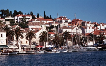
 Harbour of Hvar Town with Pakleni Islands in background - Click for larger view |
The harbour of Hvar Town, the main harbour of Hvar Island, is one of the most popular destinations in the Croatian islands, both by land tourists and by yachtsmen. Much of its popularity is due to its picturesque Venetian architectural heritage clustered inside 13th century town walls. Cars are banned from the town centre, making the town a delight to explore on foot. Among its numerous attractions are a spectacularly sited fortress, 15th century Franciscan monastery and several impressively decorated palaces and mansions, testimony to the skills of Hvar stone masons. The harbour has space for only 20 or so yachts on laid moorings along its town quay and the anchorage off it becomes impossibly crowded in July and August. An early arrival during these months is essential and even then you risk being sandwiched in the anchorage between later arrivals. Shelter in the harbour is good except in strong S and SW winds, when it becomes very uncomfortable.
Local Weather
Diurnal winds among the islands are mostly moderate during the summer months, predominantly from NW and rarely exceeding force 4/5, although gusting is common in narrow channels between islands and on the lee side of headlands. At night, katabatic winds off the mountains affect some of the islands close to the mainland coast. During early spring and (especially) autumn conditions can be more unsettled, occasionally accompanied by violent thunderstorms - luckily of short duration - with winds of 30-35 knots or more and vicious, steep seas. In the winter the sudden, violent N wind off the mountains, the bora, is much to be feared, especially along the coast from Rijeka down to Zadar, although its effects can be felt as far south as Split.
Equally prevalent in winter - although not uncommon in summer - is the scirocco, a S/SE wind that blows up from North Africa, usually in advance of a depression moving E across the Mediterranean. Unlike the bora, the scirocco only occasionally exceeds gale force, but is still a phenomenon to be wary of, especially if on a lee coast.
For sources of weather forecasting, see Croatia.
Charts
- British Admiralty
- 2712
- 269
- Croatian charts
- MK19
- Imray
- M26 (Split to Dubrovnik)
Radio Nets
Also see World Cruiser's Nets.
There are no dangers in the immediate approach to Hvar Town. Note, however, that in the approach from S there are shoals for some distance off the islet of O. Jerolim, the easternmost of the Pakleni Islands. Also that there are depths of just 5.0 metres in the passage between the islet of Galesnik half a mile S of Hvar Town and the coast of the island, which should therefore only be used in settled weather.
Check-in facilities (for Customs and Immigration)
Hvar Town is a summer port of entry. At other times of year, Split or Korcula are the nearest year-round ports of entry.
Berthing Options
There are three main berthing options:
- Town quay
-
 Yachts moored on Hvar Town quay - Click for larger view
- The best but busiest berthing spot is on the town quay at the E of the harbour, where depths are 3.0 - 4.0 metres, N of the section reserved for ferries and hydrofoils. There are laid moorings along the quay for around 20 yachts to go stern or bows-to. These moorings are often occupied by midday during the season and early arrival is recommended, especially in late July and August when the Italians arrive. There are water and electricity points along the quay. There are toilets, showers and a launderette at the NE corner of the main square, next to the cathedral.
-
- W quay mooring buoys
- There are about 20 mooring buoys laid off the quay on the W side of the bay in depths of more than 3.0 metres, which are available for visiting yachts. Yachts pick up a buoy and take a line ashore to prevent swinging. It is essential to put out fenders if using these, since they are close together. Beware the swell that can cause a lot of rocking if the wind comes from the south-east.
- W quay anchor moor
- If all the buoys are taken, it is possible with care to anchor in 4.0 - 5.0 metres S of the line of buoys and take a line ashore. Holding is good in sand and mud. Again, fenders are advisable when mooring up and when leaving.

All these mooring positions are subject to frequent wash from ferries and hydrofoils, which is an unavoidable fact of life.
Marinas & Yacht Clubs
None.
Anchorages
As of 2010 it is not allowed to drop anchor within the bay. Outside of the bay, past the mooring buoys, it is possible to anchor in 12 metres or more in settled weather.
Yacht Repairs and Services
Basic emergency repairs only.
Fuel, Water, & Electricity
Fuel berth in a small inlet on E side of bay 500 metres S of harbour (0600 - 2200). Depths of only 1.8 metres alongside. Water and electricity on the town quay.
Things to do Ashore


Tourism
Hvar Town has numerous attractions. Its main square of Trg Sveti Stjepana is one of the largest in the islands. At its E end is the impressive bell tower of the 16th century Cathedral of Sv. Stjepan and its Bishop’s Treasury museum. Around the square are imposing Gothic and Renaissance palaces. On the S side of the square is the 17th century Arsenal, subsequently adapted as one of the earliest theatres in the country. S of the harbour in a small cove is a 15th century Franciscan Monastery with a Renaissance cloister, fine church paintings and an interesting museum with early charts. To walk off a good lunch, climb to the Fortress Spanjol on the summit of a hill overlooking the harbour for fantastic views over the Pakleni Islands.
Grocery & Supply Stores
Several supermarkets, butchers and other provisions shops in the town. Fruit and vegetable market. Fish market.
Eateries
Several restaurants and café/bars ashore.
Internet/WiFi
In internet cafes.
Laundry
In the main square (self service).
Motorbike & Car Rentals
Rental outlets in the town.
Garbage Disposal
Near the harbour.
Transport
- Daily ferries to Split.
- Occasional ferries to Rijeka and Dubrovnik.
- Local buses to island destinations.
Routes/Passages To/From
See Croatia.
Cruiser's Friends
Contact details of "Cruiser's Friends" that can be contacted for local information or assistance.
Forum Discussions
List links to discussion threads on partnering forums. (see link for requirements)
External Links
- Hvar (town) at the Wikipedia
- Hvar Tourism website
For other useful websites, see Croatia.
References & Publications
See Croatia.
Personal Notes
Personal experiences?
Last Visited & Details Checked (and updated here)
Date of member's visit to this Port/Stop & this page's details validated:
- August 2005 --Athene of Lymington 17:27, 23 April 2012 (BST)
- May 2013 --Zevbahdy of London
| |
|---|
|
Names: Lighthouse, Athene of Lymington |
| Cruising Wiki Navigation
|
|---|
| | HOMEPAGE | Wiki Contents | Mediterranean | Adriatic Sea | Croatia | Hvar | Hvar Town | |