Kelibia
From CruisersWiki
Istioploos (Talk | contribs) m (Navigation Bar) |
Istioploos (Talk | contribs) (Coords & minor edits) |
||
| Line 1: | Line 1: | ||
==Kelibia (Port of entry)== | ==Kelibia (Port of entry)== | ||
| - | [[Image:Tunisia_Kelibia_h.jpg|350px|thumb|right|Chart of Kelibia<br/>''Click for larger view'']] | + | GPS: {{Coord|36|50|N|11|06.4|E|}} |
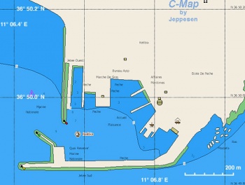
| + | [[Image:Tunisia_Kelibia_h.jpg|350px|thumb|right|Chart of Kelibia - [http://mapserver.maptech.com/homepage/index.cfm?lat=36.833333&lon=11.106667&scale=24000&zoom=50&type=1 Chartlet]<br/>''Click for larger view'']] | ||
===Background=== | ===Background=== | ||
| Line 14: | Line 15: | ||
===Approach and Navigation=== | ===Approach and Navigation=== | ||
| - | Approaches to | + | Approaches to Kelibia are straight forward, no dangers. But: |
<font color="red">Warning:</font> The entrance to the harbor may be silted. | <font color="red">Warning:</font> The entrance to the harbor may be silted. | ||
===Check-in facilities=== | ===Check-in facilities=== | ||
| - | + | GPS: {{Coord|36|50|N|11|06.4|E|}}<br/> | |
| + | The harbor is usually full of fishing boats and you may have to raft. There is pontoon for boats clearing customs. | ||
<font color="red">Warning:</font> There can be an uncomfortable swell in the harbor. | <font color="red">Warning:</font> There can be an uncomfortable swell in the harbor. | ||
| Line 84: | Line 86: | ||
====Last Visited & Details Checked (and updated here)==== | ====Last Visited & Details Checked (and updated here)==== | ||
Date of member's visit to this Port/Stop & this page's details validated: | Date of member's visit to this Port/Stop & this page's details validated: | ||
| - | * May 2001 --[[User:Istioploos|Istioploos]] | + | * May 2001 --[[User:Istioploos|Istioploos]] [[Image:Greece_Icon.png]] |
* | * | ||
Revision as of 14:07, 10 March 2009
Kelibia (Port of entry)
GPS: 36°50′N, 11°06.4′E
Background
Kelibia is a commercial fishing port. While the harbor tends to be very crowded is a convenient port for cruisers coming from Malta to check into Tunisia.
Charts
See Tunisia.
Radio Nets
Also see Cruiser's Nets
Submit details of local radio Nets.
Approaches to Kelibia are straight forward, no dangers. But:
Warning: The entrance to the harbor may be silted.
Check-in facilities
GPS: 36°50′N, 11°06.4′E
The harbor is usually full of fishing boats and you may have to raft. There is pontoon for boats clearing customs.
Warning: There can be an uncomfortable swell in the harbor.
Routes/Passages To/From
Popular passages/routes, timing, etc.
Tourism & things to do ashore
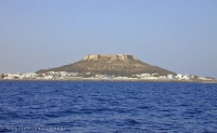
There is not very much to do here other than visiting the fort, swimming, and taking some nice long walks.
Fuel, Water, & Electricity
- Fuel - On the fuel dock
- Water - Near the fuel dock
- Electricity -
Laundry
Grocery Stores
Eateries
Motorbike & Car Rentals
Marine Stores & Facilities
Submit addresses and contact details of marine related businesses that are of interest to cruisers.
Repairs
Transportation
Transportation to mainland or other countries, etc.
References & Publications
See Tunisia.
Cruiser's Friends
Contact details of "Cruiser's Friends" that can be contacted for local information or assistance.
Forum Discussions
List links to discussion threads on the Cruiser Log Forum
External Links
- Kelibia (Wikipedia)
Personal Notes
- When we went to Kelibia in 2001, the harbor was very crowded with fishing boats and had a bad smell. We did not stay. --Istioploos 22:09, 19 August 2008 (EEST)
Last Visited & Details Checked (and updated here)
Date of member's visit to this Port/Stop & this page's details validated:
- May 2001 --Istioploos

| |
|---|
| | HOMEPAGE | Wiki Contents | Mediterranean | Tunisia | Kelibia | |
.

