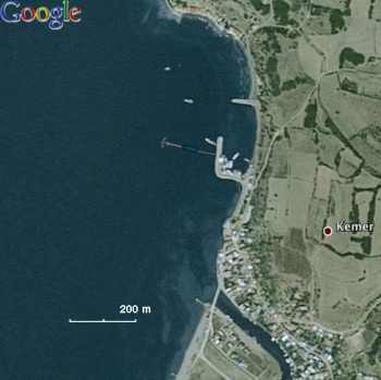
Kemer Sea of Marmara
From CruisersWiki
Kemer - Sea of Marmara
| | |
| GPS: | 40°25.3′N, 27°03.8′E |
|---|---|
| Gallery: | Photo gallery |
| Chartlet: | Local chartlet |
Background
Kemer is a conveniently located anchorage about 17.5 nM east of Gelibolu and a few miles west of Karabiga.
Charts
See Marmara Sea
Radio Nets
Also see Cruiser's Nets
Submit details of local radio Nets.
Ports and Popular Stops
It is best to anchor E of the small harbor and take a line to the mole. The harbor is very dirty and full of fishing boats. There is hamlet E of the harbor. No facilities. The water is very murky.
Routes/Passages To/From
Popular passages/routes, timing, etc.
Tourism & things to do ashore
Just a very modest fishing village. Take a nice walk.
Fuel, Water, & Electricity
N/A.
Laundry
N/A.
Grocery & Supply Stores
Very modest.
Eateries
N/A.
Internet/WiFi
Available?
Motorbike & Car Rentals
N/A.
Marine Stores & Facilities
None.
Repairs
N/A.
Transportation
Transportation to mainland or other countries, etc.
References & Publications
See Turkey.
Cruiser's Friends
Contact details of "Cruiser's Friends" that can be contacted for local information or assistance.
Forum Discussions
List links to discussion threads on partnering forums. (see link for requirements)
External Links
- Kemer (Wikipedia)
Personal Notes
Personal experiences?
Last Visited & Details Checked (and updated here)
Date of member's visit to this Port/Stop & this page's details validated:
- June 1998 --Istioploos

|
|---|
|
Names: Istioploos, Lighthouse, Haiqu |
| |
|---|
| | HOMEPAGE | Wiki Contents | Western Asia | Turkey | Marmara Sea | Kemer | |
