Olib
From CruisersWiki
Istioploos (Talk | contribs) m (Cosmetic) |
Istioploos (Talk | contribs) (Template) |
||
| (36 intermediate revisions not shown) | |||
| Line 1: | Line 1: | ||
| - | + | {{IsPartOf|Mediterranean|Adriatic Sea|Croatia|Kvarner Gulf}} | |
| - | + | {{TOC block}} | |
| - | { | + | {{Infobox |
| - | | | + | | lat= 44.38333|lon=14.787 |
| - | + | | name= Olib | |
| - | + | | portofentry= | |
| - | + | | containsportofentry= | |
| - | + | | zoom= 12 | |
| - | | | + | | chartlet = y |
| - | + | | image= OlibAerial.jpg | |
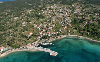
| - | | | + | | imagetext= Olib harbour from NW (before the ferry quay was extended) |
| - | | | + | | summary= [[wikipedia:Olib|'''Olib''']] Island lies off the mainland coast of [[Croatia]], two miles E of the island of [[Silba]] and five miles NE of the island of [[Molat]]. An attractive and traffic-free island with a population of only 147, Olib has a long history dating back beyond the Roman era. It has no natural water sources, so most of the water used was captured in domestic cisterns until the construction of an underwater pipeline, which now brings precious supplies to Olib. Today the island survives on fishing and tourism, supplemented by the production of products such as olive oil, wine and cheese. Yachting tourism, as with many of the smaller Croatian islands, makes a not insignificant contribution to tourist income. Visiting yachts have the option of mooring on the ferry jetty in the main harbour of Luka Olib on the W side of the island or anchoring off either here or the bay of [[#Luka Sv. Nikola|Luka Sv. Nikola]] on the SW coast. |
| - | + | | notes= | |
| - | | | + | | news= |
| - | | | + | }} |
| - | | | + | |
| - | + | ||
| - | + | ||
| - | Olib Island lies off the mainland coast of [[Croatia]], two miles E of the island of [[Silba]] and five miles NE of the island of [[Molat]]. | + | |
| - | + | ||
| - | + | ||
| - | + | ||
==Charts== | ==Charts== | ||
| - | ; British Admiralty | + | ; British Admiralty |
| - | : | + | : BA515 - Zadar to Luka Mali Losinj |
| - | ; Croatian charts | + | ; Croatian charts |
| - | : MK 9 | + | : MK 9 |
| - | ; Imray | + | : MK11 |
| - | : M25 | + | ; Imray |
| + | : M25 - Otok Rab to Sibeni | ||
==Weather== | ==Weather== | ||
| - | + | ''See [[Croatia#Weather|Croatia]]''. | |
| - | + | ==Passages== | |
| + | ''See [[Croatia#Passages|Croatia]]''. | ||
| - | + | ==Islands== | |
| + | * [[Premuda]] | ||
| + | * [[Silba]] | ||
| + | * [[Ist]] | ||
| + | * [[Molat]] | ||
| - | == | + | ==Communication== |
| - | + | {{Green|Add here VHF channel for coastguard, harbor masters. etc.}} | |
| + | * | ||
| + | * | ||
| - | |||
| - | |||
| - | + | ''Also see [[HF_Radio|Cruiser's Nets]]'' | |
| - | + | ||
| - | + | ||
| - | == | + | ==Navigation== |
| - | + | {{GreenText|Any navigation notes here. If this section does not apply, remove it.}} | |
| - | == | + | ==Entrance== |
| - | + | [[Mali Lošinj]] is the nearest port of entry. In the summer only, [[Božava]] on [[Dugi Otok]] is also a port of entry. | |
| - | ==== | + | ==Berthing== |
| - | + | There are three berthing options on Olib Island: | |
| + | ===Ports=== | ||
| + | {{Poi | lat= 44.3795657902355 | lon= 14.77521990072013 | type= harbour | name= Luka Olib | zoom= 17 | ||
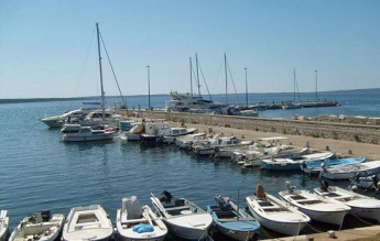
| + | | image= OlibJetty.jpg | imagetext= Yachts moored on Olib jetty (note the quay extension at top | imagewidth= | ||
| + | | text= The port of Luka Olib is situated on the W coast of the island, at the head of a nearly two-mile wide bay. If approaching from N, note that the islet of Hrid Kujack has dangerous rocks off it and shallows extending all the way NNE across to the island. The port consists of a tiny, shallow small craft harbour unsuitable for yachts and a long ferry pier with laid moorings on either side for visiting yachts. Water and electricity on the quay. On the S side, starting at the yellow marker, there is place for 10 yachts. Depth at the quay 2.3 meters. This part is relatively shallow so beware of the mooring lines. The inner end of the S quay is taken up by small local boats. On the E side, Depths are 4.0 metres but this part is more exposed. There is place for 10 Yachts. The W side is reserved for ferries and tripper boats up to the yellow marker. Shelter here is moderate to good, depending on wind strength and direction, but it is not a good place to be with very strong winds from N through W to SW. }} | ||
| - | == | + | ===Marinas & Yacht Clubs=== |
| - | + | None. | |
| - | + | ||
| - | + | ||
| - | + | ||
| - | == | + | ==Anchorages== |
| - | === | + | {{Poi | lat= 44.3795657902355 | lon= 14.77521990072013 | type= buoy | name= Luka Olib moorings | zoom= 17 |
| - | + | | image= | imagetext= | imagewidth= | |
| - | + | | text= Alternatively to the harbor, pick up one of the mooring buoys laid to the N and S of the harbour. The moorings are mostly in depths of 6.0 - 8.0 metres and offer reasonable shelter in settled conditions but are rather exposed in any winds from N round to SW. If all the buoys are taken, anchor in 6.0 - 7.0 metres wherever there is space. Holding is good in sand. }} | |
| - | === | + | {{Poi | lat= 44.352995037681694 | lon= 14.773333438623478 | type= anchorage | name= Luka Sv. Nikola | zoom= 16 |
| - | + | | image= | imagetext= | imagewidth= | |
| - | + | | text= Luka Sv. Nikola lies on the SW coast of the island, some two miles NW from the southern tip of Olib. The bay has two arms and the better anchorage is in the W arm. Anchor in depths of 3.0 - 6.0 metres and, if necessary, take a line to one of the bollards dotted along the shore on both sides of the anchorage. The holding is good in sand and weed. Shelter here is good from all directions except S. }} | |
| - | == | + | ==Amenities== |
| - | + | {{tlist | |
| - | + | |header|Facilities | |
| - | + | ||
| - | === | + | |Water| {{mark |name= [[#Luka Olib|Luka Olib]]| type= water | lat= 44.3795657902355 | lon= 14.77521990072013 | zoom= 17 |text= Water at all berths on the breakwater and the E side of the jetty.}} |
| - | + | |Electricity| {{mark |name= [[#Luka Olib|Luka Olib]]| type= electricity | lat= 44.3795657902355 | lon= 14.77521990072013 | zoom= 17 |text= Electricity at all berths on the breakwater and the E side of the jetty.}} | |
| + | |Toilets| {{MagentaText|?}} | ||
| + | |Showers| {{MagentaText|?}} | ||
| + | |Laundry| N/A (Not Available) | ||
| + | |Garbage| {{MagentaText|?}} | ||
| - | + | |header|Supplies | |
| - | None | + | |Fuel| N/A |
| + | |Bottled gas| N/A | ||
| + | |Chandlers| None | ||
| - | + | |header|Services | |
| - | + | |Repairs| N/A | |
| + | |Internet| WiFi in the internet cafe | ||
| + | |Mobile connectivity| {{Green|Is there mobile telephone signal such as G4, G3, GPRS on the island? How strong is the signal? Are there any blind spots?}} | ||
| + | |Vehicle rentals| N/A | ||
| + | }} | ||
| - | == | + | ==Provisioning== |
| - | + | {{mark |name= [[#Luka Olib|Luka Olib]]| type= provisions | lat= 44.3795657902355 | lon= 14.77521990072013 | zoom= 17 |text= Grocery store near the harbour, bakery.}}}} | |
| - | + | ||
| - | == | + | ==Eating out== |
| - | + | * Village | |
| - | + | : {{mark |name= | type= eatingout | lat= 44.37583| lon=14.78065 |zoom=14 |text=Several restaurants.}} | |
| - | + | ||
| - | == | + | |
| - | + | ||
| - | + | ||
| - | + | ||
| - | + | ||
| - | + | ||
| - | |||
| - | |||
| - | == | + | ==Transportation== |
| - | + | Ferries to [[Rijeka]] and [[Zadar]] on mainland and adjacent islands. | |
| + | |||
| + | ==Tourism== | ||
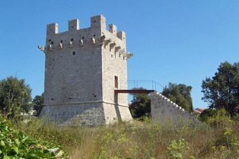
| + | {{Image right|OlibTower.jpg| The 17th century defensive tower }} | ||
| + | ====History==== | ||
| + | {{Green|Give a short history of the island.}} | ||
| + | |||
| + | ====Places to Visit==== | ||
| + | Olib is a peaceful spot, virtually traffic-free and its main harbour is popular during the season with visiting yacht crews. Ashore there is little to do but appreciate the quiet charm of the village on the island or stroll its numerous pathways. The village contains an impressive defensive tower built for protection from pirates in the 17th century. The church of the Assumption of Mary holds a number of codices in the ancient Glagolitic language. | ||
| + | |||
| + | ==Friends== | ||
| + | Contact details of "Cruiser's Friends" that can be contacted for local information or assistance. | ||
* | * | ||
| - | ==== | + | ==Forums== |
| - | '' | + | List links to discussion threads on [[Cruising Forums|partnering forums]]. (''see link for requirements'') |
| - | * | + | * [http://www.cruisersforum.com/forums/tags/croatia.html Croatia Sailing and Cruising Discussions on Cruisers Forum] |
| + | * | ||
| + | ==Links== | ||
| + | * {{Wikipedia}} | ||
| + | * [http://www.about-croatia.com/croatia-marina.php List of all Croatian marinas] | ||
| + | * [http://croatia.hr/en-GB/Homepage Croatian National Tourist Board] | ||
| + | * [http://www.find-croatia.com Find Croatia travel guide] | ||
| + | * [http://www.noonsite.com/Countries/Croatia/olib Noonsite] | ||
| - | {{ | + | ==References== |
| + | ''See [[Croatia#References|Croatia]]''. | ||
| + | |||
| + | {{Comments}} | ||
| + | * | ||
| + | * | ||
| + | |||
| + | {{Verified by}} | ||
| + | * July 2004 --[[User:Atheneoflymington|Athene of Lymington]] 15:04, 21 April 2012 (BST) | ||
| + | * September 2013 --[[User:Salacia|Salacia]] 21:06, 28 September 2013 (BST) | ||
| + | * | ||
| - | + | {{Page useable}} | |
| - | { | + | |
| - | + | ||
| - | + | ||
| - | + | ||
| - | + | ||
| - | + | ||
| - | |||
| - | |||
| - | |||
| - | |||
| - | |||
| - | |||
| + | {{Contributors|[[User:Lighthouse|Lighthouse]], [[User:Atheneoflymington|Athene of Lymington]], [[User:Salacia|Salacia]]}} | ||
| - | [[Category:Islands - Croatia]] | + | [[Category:Islands - Croatia]] [[Category:Ports - Croatia]] [[Category:Anchorages - Croatia]] |
Latest revision as of 21:46, 11 March 2019
| Olib
| |
| | |
Olib Island lies off the mainland coast of Croatia, two miles E of the island of Silba and five miles NE of the island of Molat. An attractive and traffic-free island with a population of only 147, Olib has a long history dating back beyond the Roman era. It has no natural water sources, so most of the water used was captured in domestic cisterns until the construction of an underwater pipeline, which now brings precious supplies to Olib. Today the island survives on fishing and tourism, supplemented by the production of products such as olive oil, wine and cheese. Yachting tourism, as with many of the smaller Croatian islands, makes a not insignificant contribution to tourist income. Visiting yachts have the option of mooring on the ferry jetty in the main harbour of Luka Olib on the W side of the island or anchoring off either here or the bay of Luka Sv. Nikola on the SW coast.
Charts
- British Admiralty
- BA515 - Zadar to Luka Mali Losinj
- Croatian charts
- MK 9
- MK11
- Imray
- M25 - Otok Rab to Sibeni
Weather
See Croatia.
Passages
See Croatia.
Islands
Communication
Add here VHF channel for coastguard, harbor masters. etc.
Also see Cruiser's Nets
Any navigation notes here. If this section does not apply, remove it.
Entrance
Mali Lošinj is the nearest port of entry. In the summer only, Božava on Dugi Otok is also a port of entry.
Berthing
There are three berthing options on Olib Island:
Ports
Luka Olib
Marinas & Yacht Clubs
None.
Anchorages
Luka Olib moorings
Luka Sv. Nikola
Amenities
| Facilities | |
|---|---|
| Water | |
| Electricity | |
| Toilets | ? |
| Showers | ? |
| Laundry | N/A (Not Available) |
| Garbage | ? |
| Supplies | |
| Fuel | N/A |
| Bottled gas | N/A |
| Chandlers | None |
| Services | |
| Repairs | N/A |
| Internet | WiFi in the internet cafe |
| Mobile connectivity | Is there mobile telephone signal such as G4, G3, GPRS on the island? How strong is the signal? Are there any blind spots? |
| Vehicle rentals | N/A |
Provisioning
![]() Luka Olib [[Olib#Luka Olib|Luka Olib]] 44°22.774'N, 014°46.513'E Grocery store near the harbour, bakery.}}
Luka Olib [[Olib#Luka Olib|Luka Olib]] 44°22.774'N, 014°46.513'E Grocery store near the harbour, bakery.}}
Eating out
- Village
-
 [[Olib# | ]] 44°22.550'N, 014°46.839'E Several restaurants.
Transportation
Ferries to Rijeka and Zadar on mainland and adjacent islands.
Tourism
History
Give a short history of the island.
Places to Visit
Olib is a peaceful spot, virtually traffic-free and its main harbour is popular during the season with visiting yacht crews. Ashore there is little to do but appreciate the quiet charm of the village on the island or stroll its numerous pathways. The village contains an impressive defensive tower built for protection from pirates in the 17th century. The church of the Assumption of Mary holds a number of codices in the ancient Glagolitic language.
Friends
Contact details of "Cruiser's Friends" that can be contacted for local information or assistance.
Forums
List links to discussion threads on partnering forums. (see link for requirements)
Links
- Olib at the Wikipedia
- List of all Croatian marinas
- Croatian National Tourist Board
- Find Croatia travel guide
- Noonsite
References
See Croatia.
Comments
We welcome users' contributions to the Wiki. Please click on Comments to view other users' comments, add your own personal experiences or recommend any changes to this page following your visit.
Verified by
Date of member's last visit to Olib and this page's details validated:
- July 2004 --Athene of Lymington 15:04, 21 April 2012 (BST)
- September 2013 --Salacia 21:06, 28 September 2013 (BST)
| This is a usable page of the cruising guide. However, please contribute if you can to help it grow further. Click on Comments to add your personal notes on this page or to discuss its contents. Alternatively, if you feel confident to edit the page, click on the edit tab at the top and enter your changes directly. |
| |
|---|
|
Names: Lighthouse, Athene of Lymington, Salacia |


