Polače
From CruisersWiki
Istioploos (Talk | contribs) m (→Last Visited & Details Checked (and updated here): Cosmetic) |
Istioploos (Talk | contribs) (Chartlet) |
||
| Line 1: | Line 1: | ||
| - | == | + | {{Infobox |42|47.3|N|17|22.76|E| |
| - | {| class="infobox bordered" style="width: | + | | mapzoom= 15 |
| + | | image= PolaceWaterfront.jpg | ||
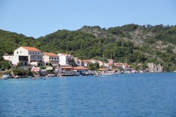
| + | | imagetext= The quays of Polace are occupied with restaurant moorings - ''Click for larger view'' | ||
| + | }} {{TOCleft}} | ||
| + | {| class="infobox bordered" style="width: 28em; text-align: right; font-size: 90%;" | ||
|- | |- | ||
| - | + | | colspan="2" style="text-align:center;" | <googlemap lat="42.793259" lon="17.399769" zoom="13" width="352" scale="yes"></googlemap> | |
| - | + | ||
| - | + | ||
| - | + | ||
| - | + | ||
| - | + | ||
| - | + | ||
| - | + | ||
| - | + | ||
| - | + | ||
| - | + | ||
| - | + | ||
| - | | colspan="2" style="text-align:center;" | <googlemap lat="42.793259" lon="17.399769" zoom="13" width=" | + | |
| - | </googlemap> | + | |
|} | |} | ||
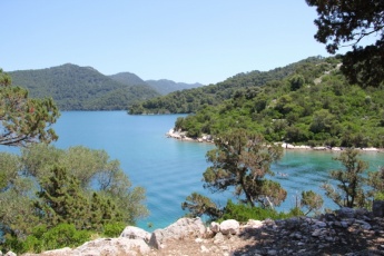
| - | + | The harbour of Polače is situated at the NW end of the island of [[Mljet]] in [[Croatia]], at the head of a two mile-long inlet sheltered from N winds by a chain of islands. Together with [[Pomena]] harbour on the W coast, Polace is one of two convenient harbours where one can safely leave a boat for a visit to the attractions of the Mljet National Park. There are traces of human habitation here dating back to pre-Roman times, but it was during the Roman era that Polace first attracted permanent settlement with the construction of the fortified castle, the ruins of which overlook the shore and are thought to date back to the 3rd or 4th century AD. The present village largely dates from the late 17th and early 18th centuries. The institution of the National Park in the 1960s, coupled with a certain resistance to rapid change on the part of the islanders, has kept Polace relatively unspoilt. However, it has not prevented the establishment of serried ranks of (somewhat pricey) restaurants along the S shores of the bay. Mooring options are effectively limited to anchoring off in the bay, with a line ashore if preferred, or picking up one of the laid moorings on the quay, all of which are reserved for restaurant patrons only. Shelter in Polace is good in most conditions, although in very strong E winds it is probably wise to move round to [[Pomena]] for better shelter. | |
| - | + | ||
| - | + | ==Local Weather== | |
| - | + | Diurnal winds among the islands are mostly moderate during the summer months, predominantly from NW and rarely exceeding force 4/5, although gusting is common in narrow channels between islands and on the lee side of headlands. At night, katabatic winds off the mountains affect some of the islands close to the mainland coast. During early spring and (especially) autumn conditions can be more unsettled, occasionally accompanied by violent thunderstorms - luckily of short duration - with winds of 30-35 knots or more and vicious, steep seas. In the winter the sudden, violent N wind off the mountains, the ''bora'', is much to be feared, especially along the coast from Rijeka down to Zadar, although its effects can be felt as far south as Split. | |
| - | The harbour of | + | |
| + | Equally prevalent in winter - although not uncommon in summer - is the ''scirocco'', a S/SE wind that blows up from North Africa, usually in advance of a depression moving E across the Mediterranean. Unlike the ''bora'', the ''scirocco'' only occasionally exceeds gale force, but is still a phenomenon to be wary of, especially if on a lee coast. | ||
| + | |||
| + | ''For sources of weather forecasting, see [[Croatia#Sources of weather forecast info|Croatia]]''. | ||
==Charts== | ==Charts== | ||
| Line 31: | Line 25: | ||
: M26 (Split to Dubrovnik) | : M26 (Split to Dubrovnik) | ||
| - | == | + | ==Radio Nets== |
| - | + | * | |
| + | * | ||
| - | + | ''Also see [[World MM Nets|World Cruiser's Nets]]''. | |
| - | + | ||
| - | + | ||
==Approach and Navigation== | ==Approach and Navigation== | ||
| Line 44: | Line 37: | ||
[[Korcula Town]] or [[Dubrovnik]] are the nearest year-round ports of entry. | [[Korcula Town]] or [[Dubrovnik]] are the nearest year-round ports of entry. | ||
| - | ==Berthing | + | ==Berthing Options== |
| - | + | {{Image right| RestoranDalmatinac.jpg| The quay of the Restoran Dalmatinac - ''Click for larger view''}} | |
| + | |||
Yachts visiting Polace have four berthing options, depending on whether the crews wish to eat ashore or not: | Yachts visiting Polace have four berthing options, depending on whether the crews wish to eat ashore or not: | ||
| - | ''' | + | # '''Restaurant quay''' |
| - | + | #: Virtually the whole quay on the S side of the bay is taken up with restaurant moorings, where yachts can enjoy a laid mooring and often water and electricity in return for patronizing the appropriate restaurant. Depths on the quays are mostly 3.0 - 4.0 metres, although this drops to a metre or less W of the ferry jetty and 2.0 – 3.0 metres on the quay next to the castle. There are at least six restaurants to choose from, so it sometimes pays to cruise up and down before selecting one. | |
| - | Virtually the whole quay on the S side of the bay is taken up with restaurant moorings, where yachts can enjoy a laid mooring and often water and electricity in return for patronizing the appropriate restaurant. Depths on the quays are mostly 3.0 - 4.0 metres, although this drops to a metre or less W of the ferry jetty and 2.0 – 3.0 metres on the quay next to the castle. There are at least six restaurants to choose from, so it sometimes pays to cruise up and down before selecting one. | + | # '''Restaurant mooring buoys''' |
| - | + | #: For slightly better peace and quiet, it may be possible to pick up one of the mooring buoys N of the ferry jetty and opposite the Roman castle ruins. At least some of these appear to be owned by one of the restaurants and you may be obliged to eat ashore if you pick one up. Depths at the buoys are 10-12 metres, but drop to only 4.0 metres to the N of the buoys. Note that in June 2014 these buoys were no longer in evidence and may have been removed. --[[User:Atheneoflymington|Athene of Lymington]] | |
| - | ''' | + | # '''Anchorage''' |
| - | + | #: Most yachts prefer to anchor off in the bay, although even this option does not afford much peace and quiet during the summer months as the anchorage can get very crowded. Anchor in 7.0 - 8.0 metres on the NW side of the bay, taking a line ashore if preferred. The wooded setting is beautiful here and the holding is excellent in mud and weed. Shelter here is also excellent in all but very strong E winds. Note: avoid anchoring anywhere near the rocky patch off the castle on the N side of the mooring buoys. The depths here may seem better but the bottom has numerous large rocks to snag your anchor. | |
| - | For slightly better peace and quiet, it may be possible to pick up one of the mooring buoys N of the ferry jetty and opposite the Roman castle ruins. At least some of these appear to be owned by one of the restaurants and you may be obliged to eat ashore if you pick one up. Depths at the buoys are 10-12 metres, but drop to only 4.0 metres to the N of the buoys. Note that in June 2014 these buoys were no longer in evidence and may have been removed. --[[User:Atheneoflymington|Athene of Lymington]] | + | # '''Restoran Dalmatinac''' {{Poi coord|42|47.136|N|17|24.319|E|}} |
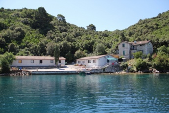
| - | + | #: Half a mile E of Polace in the cove of Uvala Tatinica, sheltered from N by Otok Kobrava, is the family-run Restoran Dalmatinac, which has four moorings for patrons and two buoys in depths of 4.0 – 5.0 metres in a delightfully peaceful and sheltered cove. Water, electricity and wifi available. | |
| - | ''' | + | |
| - | + | ||
| - | Most yachts prefer to anchor off in the bay, although even this option does not afford much peace and quiet during the summer months as the anchorage can get very crowded. Anchor in 7.0 - 8.0 metres on the NW side of the bay, taking a line ashore if preferred. The wooded setting is beautiful here and the holding is excellent in mud and weed. Shelter here is also excellent in all but very strong E winds. Note: avoid anchoring anywhere near the rocky patch off the castle on the N side of the mooring buoys. The depths here may seem better but the bottom has numerous large rocks to snag your anchor. | + | |
| - | + | ||
| - | ''' | + | |
| - | + | ||
| - | + | ||
| - | Half a mile E of Polace in the cove of Uvala Tatinica, sheltered from N by Otok Kobrava, is the family-run Restoran Dalmatinac, which has four moorings for patrons and two buoys in depths of 4.0 – 5.0 metres in a delightfully peaceful and sheltered cove. Water, electricity and wifi available. | + | |
| - | ==Marinas & Yacht Clubs== | + | ===Marinas & Yacht Clubs=== |
None. | None. | ||
| - | ==Anchorages== | + | ===Anchorages=== |
| - | In addition to the anchorage in the harbour, there is an alternative settled weather anchorage in peaceful surroundings in the bay on the W side of O. Moracnik | + | {{Image right| PolaceAnchorage.jpg| The anchorage of Polace from NW - ''Click for larger view''}} |
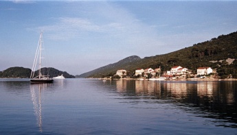
| + | In addition to the anchorage in the harbour, there is an alternative settled weather anchorage in peaceful surroundings in the bay on the W side of O. Moracnik {{Poi coord|42|47.7|N|17|23.7|E|}}. You are dropping anchor in 10-12 metres here, so it is probably wise to take a line ashore. Shelter is good in most conditions except with very strong SW winds. Holding is good in sand and mud. | ||
==Yacht Repairs and Services== | ==Yacht Repairs and Services== | ||
| Line 76: | Line 63: | ||
====Fuel, Water, & Electricity==== | ====Fuel, Water, & Electricity==== | ||
No fuel. Water and electricity at some of the restaurant quays. | No fuel. Water and electricity at some of the restaurant quays. | ||
| + | {{hold vertical}} | ||
==Things to do Ashore== | ==Things to do Ashore== | ||
====Tourism==== | ====Tourism==== | ||
| - | + | {{Image right| PolaceCastle.jpg| The Roman castle - ''Click for larger view''}} | |
| - | + | {{Image right| MljetLakes.jpg| The lakes are a magnet for tourists on Mljet - ''Click for larger view''}} | |
| - | + | {{Image right| MljetBikes.jpg| Cycle hire is a popular way to see the Mljet National Park<br />''Click for larger view''}} | |
| - | + | {{Image right| MljetMonastery2.jpg| The former Benedictine monastery on an island in Veliko Jezero<br />''Click for larger view''}} | |
| + | {{Image right| MljetFerry.jpg| A ferry takes bikes and riders across at the E end of the lakes <br />''Click for larger view''}} | ||
| + | |||
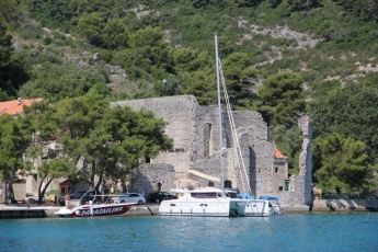
In Polace itself the main attractions are the remains of a Roman palace, dating back to the 5th or 6th centuries, which are conspicuous on the W side of the bay. Next to the ruins are the remains of a 5th century early Christian basilica. However, the ‘must see’ attractions of Mljet Island are the two interconnected lakes, Malo and Veliko Jezero, at the NW end of the island. The lakes are in the national park and an entry fee of 100 kuna (2014) per person is payable on mooring in Polace or [[Pomena]] (though not if only dining at the restaurants). This price includes entry to the park (valid for a week), a bus to and from Veliko Jezero and access (via a short boat ride) to the former Benedictine monastery of Sv. Marija, which is being steadily restored following damage during Croatia's war of independence and has a cafe and restaurant. It is also possible to walk or cycle the route to and around the lakes (cycles can be hired in the village or at the lakes themselves), which is a much more rewarding if rather more energetic option. Between the two lakes is a channel dug by the Benedictine monks to provide motive power for a mill from the tidal currents into Veliko Jezero. Depending on the state of tide, a current can be seen rushing through the shallow sea inlet at the E end of Veliko Jezero, the pleasant walk or cycle to which goes along the S side of the lake. Except when the current is very strong, a ferry boat takes pedestrians and cyclists (with their bikes) across the narrows to enable them to complete the circuit of the lakes. | In Polace itself the main attractions are the remains of a Roman palace, dating back to the 5th or 6th centuries, which are conspicuous on the W side of the bay. Next to the ruins are the remains of a 5th century early Christian basilica. However, the ‘must see’ attractions of Mljet Island are the two interconnected lakes, Malo and Veliko Jezero, at the NW end of the island. The lakes are in the national park and an entry fee of 100 kuna (2014) per person is payable on mooring in Polace or [[Pomena]] (though not if only dining at the restaurants). This price includes entry to the park (valid for a week), a bus to and from Veliko Jezero and access (via a short boat ride) to the former Benedictine monastery of Sv. Marija, which is being steadily restored following damage during Croatia's war of independence and has a cafe and restaurant. It is also possible to walk or cycle the route to and around the lakes (cycles can be hired in the village or at the lakes themselves), which is a much more rewarding if rather more energetic option. Between the two lakes is a channel dug by the Benedictine monks to provide motive power for a mill from the tidal currents into Veliko Jezero. Depending on the state of tide, a current can be seen rushing through the shallow sea inlet at the E end of Veliko Jezero, the pleasant walk or cycle to which goes along the S side of the lake. Except when the current is very strong, a ferry boat takes pedestrians and cyclists (with their bikes) across the narrows to enable them to complete the circuit of the lakes. | ||
| Line 106: | Line 96: | ||
* Ferries via [[Sobra]] to [[Dubrovnik]] | * Ferries via [[Sobra]] to [[Dubrovnik]] | ||
* Local ferries to Trstenik on mainland. | * Local ferries to Trstenik on mainland. | ||
| + | |||
| + | ==Routes/Passages To/From== | ||
| + | ''See [[Croatia#Popular_Routes.2FCruises|Croatia]]''. | ||
==Cruiser's Friends== | ==Cruiser's Friends== | ||
| Line 112: | Line 105: | ||
==Forum Discussions== | ==Forum Discussions== | ||
| - | List links to discussion threads on [[Cruising Forums|partnering forums]]. (see link for requirements) | + | List links to discussion threads on [[Cruising Forums|partnering forums]]. (''see link for requirements'') |
* [http://www.cruisersforum.com/forums/tags/croatia.html Croatia Sailing and Cruising Discussions on Cruisers Forum] | * [http://www.cruisersforum.com/forums/tags/croatia.html Croatia Sailing and Cruising Discussions on Cruisers Forum] | ||
| - | * | + | * |
==External Links== | ==External Links== | ||
| + | * {{wikipedia|Polače}} | ||
| + | * | ||
| + | |||
''See [[Croatia#External Links|Croatia]]''. | ''See [[Croatia#External Links|Croatia]]''. | ||
| Line 125: | Line 121: | ||
Personal experiences? | Personal experiences? | ||
* | * | ||
| + | |||
====Last Visited & Details Checked (and updated here)==== | ====Last Visited & Details Checked (and updated here)==== | ||
''Date of member's visit to this Port/Stop & this page's details validated'': | ''Date of member's visit to this Port/Stop & this page's details validated'': | ||
* July 2014 --[[User:Atheneoflymington|Athene of Lymington]] | * July 2014 --[[User:Atheneoflymington|Athene of Lymington]] | ||
| + | * | ||
| + | {{hold vertical}} | ||
| - | {{ | + | {{Page useable}} |
| - | + | {{Contributors|[[User:Lighthouse|Lighthouse]], [[User:Atheneoflymington|Athene of Lymington]]}} | |
| - | { | + | |
| - | + | ||
| - | | | + | |
| - | + | ||
| - | + | ||
| - | + | ||
| - | + | ||
| - | + | ||
| - | + | ||
| - | + | ||
| - | + | ||
| - | + | ||
| - | + | ||
| - | + | ||
| + | {{Navbar| [[Mediterranean]] | [[Adriatic Sea]] | [[Croatia]] | [[Mljet]] | [[Polace]] }} | ||
[[Category:Ports - Croatia]] [[Category:Anchorages - Croatia]] | [[Category:Ports - Croatia]] [[Category:Anchorages - Croatia]] | ||
Revision as of 17:35, 6 July 2015
| Polače
| |
The harbour of Polače is situated at the NW end of the island of Mljet in Croatia, at the head of a two mile-long inlet sheltered from N winds by a chain of islands. Together with Pomena harbour on the W coast, Polace is one of two convenient harbours where one can safely leave a boat for a visit to the attractions of the Mljet National Park. There are traces of human habitation here dating back to pre-Roman times, but it was during the Roman era that Polace first attracted permanent settlement with the construction of the fortified castle, the ruins of which overlook the shore and are thought to date back to the 3rd or 4th century AD. The present village largely dates from the late 17th and early 18th centuries. The institution of the National Park in the 1960s, coupled with a certain resistance to rapid change on the part of the islanders, has kept Polace relatively unspoilt. However, it has not prevented the establishment of serried ranks of (somewhat pricey) restaurants along the S shores of the bay. Mooring options are effectively limited to anchoring off in the bay, with a line ashore if preferred, or picking up one of the laid moorings on the quay, all of which are reserved for restaurant patrons only. Shelter in Polace is good in most conditions, although in very strong E winds it is probably wise to move round to Pomena for better shelter.
Local Weather
Diurnal winds among the islands are mostly moderate during the summer months, predominantly from NW and rarely exceeding force 4/5, although gusting is common in narrow channels between islands and on the lee side of headlands. At night, katabatic winds off the mountains affect some of the islands close to the mainland coast. During early spring and (especially) autumn conditions can be more unsettled, occasionally accompanied by violent thunderstorms - luckily of short duration - with winds of 30-35 knots or more and vicious, steep seas. In the winter the sudden, violent N wind off the mountains, the bora, is much to be feared, especially along the coast from Rijeka down to Zadar, although its effects can be felt as far south as Split.
Equally prevalent in winter - although not uncommon in summer - is the scirocco, a S/SE wind that blows up from North Africa, usually in advance of a depression moving E across the Mediterranean. Unlike the bora, the scirocco only occasionally exceeds gale force, but is still a phenomenon to be wary of, especially if on a lee coast.
For sources of weather forecasting, see Croatia.
Charts
- British Admiralty
- 1580
- Croatian charts
- MK24
- Imray
- M26 (Split to Dubrovnik)
Radio Nets
Also see World Cruiser's Nets.
The approach from E is via the two-mile long channel between Mljet island and the long island of O. Kobrava to the N, which is entered by leaving the rocky reef of Hrid Kula (marked with a light structure) to port. The approach from N, between Mljet and the island of O. Moracnik has two dangers to be avoided: firstly, the islet of Skoljic 200 metres W of the northernmost tip of O. Moracnik has shoals extending for nearly 100 metres W; secondly, on the coast of Mljet opposite the S end of O. Moracnik there is a rocky spit extending nearly 200 metres into the channel, which could be dangerous in poor visibility. It is also possible to approach on the N side of O. Kobrava, between it and O. Ovrata and then between O. Moracnik and O. Tajnik. This approach is free of dangers and is the one normally used by the ferries.
Check-in facilities (for Customs and Immigration)
Korcula Town or Dubrovnik are the nearest year-round ports of entry.
Berthing Options
Yachts visiting Polace have four berthing options, depending on whether the crews wish to eat ashore or not:
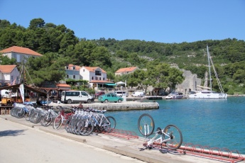
- Restaurant quay
- Virtually the whole quay on the S side of the bay is taken up with restaurant moorings, where yachts can enjoy a laid mooring and often water and electricity in return for patronizing the appropriate restaurant. Depths on the quays are mostly 3.0 - 4.0 metres, although this drops to a metre or less W of the ferry jetty and 2.0 – 3.0 metres on the quay next to the castle. There are at least six restaurants to choose from, so it sometimes pays to cruise up and down before selecting one.
- Restaurant mooring buoys
- For slightly better peace and quiet, it may be possible to pick up one of the mooring buoys N of the ferry jetty and opposite the Roman castle ruins. At least some of these appear to be owned by one of the restaurants and you may be obliged to eat ashore if you pick one up. Depths at the buoys are 10-12 metres, but drop to only 4.0 metres to the N of the buoys. Note that in June 2014 these buoys were no longer in evidence and may have been removed. --Athene of Lymington
- Anchorage
- Most yachts prefer to anchor off in the bay, although even this option does not afford much peace and quiet during the summer months as the anchorage can get very crowded. Anchor in 7.0 - 8.0 metres on the NW side of the bay, taking a line ashore if preferred. The wooded setting is beautiful here and the holding is excellent in mud and weed. Shelter here is also excellent in all but very strong E winds. Note: avoid anchoring anywhere near the rocky patch off the castle on the N side of the mooring buoys. The depths here may seem better but the bottom has numerous large rocks to snag your anchor.
- Restoran Dalmatinac Template:Poi coord
- Half a mile E of Polace in the cove of Uvala Tatinica, sheltered from N by Otok Kobrava, is the family-run Restoran Dalmatinac, which has four moorings for patrons and two buoys in depths of 4.0 – 5.0 metres in a delightfully peaceful and sheltered cove. Water, electricity and wifi available.
Marinas & Yacht Clubs
None.
Anchorages
In addition to the anchorage in the harbour, there is an alternative settled weather anchorage in peaceful surroundings in the bay on the W side of O. Moracnik Template:Poi coord. You are dropping anchor in 10-12 metres here, so it is probably wise to take a line ashore. Shelter is good in most conditions except with very strong SW winds. Holding is good in sand and mud.
Yacht Repairs and Services
None.
Fuel, Water, & Electricity
No fuel. Water and electricity at some of the restaurant quays.
Things to do Ashore
Tourism
In Polace itself the main attractions are the remains of a Roman palace, dating back to the 5th or 6th centuries, which are conspicuous on the W side of the bay. Next to the ruins are the remains of a 5th century early Christian basilica. However, the ‘must see’ attractions of Mljet Island are the two interconnected lakes, Malo and Veliko Jezero, at the NW end of the island. The lakes are in the national park and an entry fee of 100 kuna (2014) per person is payable on mooring in Polace or Pomena (though not if only dining at the restaurants). This price includes entry to the park (valid for a week), a bus to and from Veliko Jezero and access (via a short boat ride) to the former Benedictine monastery of Sv. Marija, which is being steadily restored following damage during Croatia's war of independence and has a cafe and restaurant. It is also possible to walk or cycle the route to and around the lakes (cycles can be hired in the village or at the lakes themselves), which is a much more rewarding if rather more energetic option. Between the two lakes is a channel dug by the Benedictine monks to provide motive power for a mill from the tidal currents into Veliko Jezero. Depending on the state of tide, a current can be seen rushing through the shallow sea inlet at the E end of Veliko Jezero, the pleasant walk or cycle to which goes along the S side of the lake. Except when the current is very strong, a ferry boat takes pedestrians and cyclists (with their bikes) across the narrows to enable them to complete the circuit of the lakes.
Grocery & Supply Stores
Basic provisions shops in the village.
Eateries
Several restaurants (six as of 2014) along the quays, most with their own moorings. Café/bar near the Roman castle ruins.
Internet/WiFi
At most of the restaurants.
Laundry
None.
Motorbike & Car Rentals
Cycle rental only.
Garbage Disposal
Limited. Take it with you.
Transport
Routes/Passages To/From
See Croatia.
Cruiser's Friends
Contact details of "Cruiser's Friends" that can be contacted for local information or assistance.
Forum Discussions
List links to discussion threads on partnering forums. (see link for requirements)
External Links
- Polače at the Wikipedia
See Croatia.
References & Publications
See Croatia.
Personal Notes
Personal experiences?
Last Visited & Details Checked (and updated here)
Date of member's visit to this Port/Stop & this page's details validated:
- July 2014 --Athene of Lymington
| This is a usable page of the cruising guide. However, please contribute if you can to help it grow further. Click on Comments to add your personal notes on this page or to discuss its contents. Alternatively, if you feel confident to edit the page, click on the edit tab at the top and enter your changes directly. |
| |
|---|
|
Names: Lighthouse, Athene of Lymington |
| Cruising Wiki Navigation
|
|---|
| | HOMEPAGE | Wiki Contents | Mediterranean | Adriatic Sea | Croatia | Mljet | Polace | |
