Sea of Marmara
From CruisersWiki
Istioploos (Talk | contribs) m (Reverted edits by Riley Huntley (talk) to last revision by Istioploos) |
m (Text replace - "==References & Publications==" to "==References==") |
||
| (23 intermediate revisions not shown) | |||
| Line 1: | Line 1: | ||
| - | + | {{IsPartOf|Mediterranean|Turkey}} | |
| - | {| | + | {{Page imagemap|clear=y}} |
| - | | | + | {{TOC block}} |
| - | + | ||
| - | + | The [http://en.wikipedia.org/wiki/Sea_of_Marmara Sea of Marmara] (Turkish: Marmara Denizi, Greek: Θάλασσα του Μαρμαρά or Προποντίς, Bulgarian: Мраморно море,Hungarian: Márvány-tenger (Marble sea), also known as the Sea of Marmora or the Marmara Sea, and in the context of classical antiquity as Propontis (Greek: Προποντίς), is the inland sea that connects the [[Black Sea]] to the Aegean Sea, thus separating the Asian part of [[Turkey]] from its European part. The [[Bosphorus]] strait connects it to the [[Black Sea]] and the [[Dardanelles]] strait to the Aegean. The former also separates [[Istanbul]] into its Asian side and European side. The Sea has an area of 11,350 km<sup>2</sup> and is about 150 nM (280 km) long and 43 nM (80 km) wide. | |
| - | + | ||
| - | + | ||
| - | + | ||
| - | + | ||
| - | + | ||
| - | + | ||
| - | + | ||
| - | + | ||
| - | + | ||
| - | + | ||
| - | + | ||
| - | + | ||
| - | The [http://en.wikipedia.org/wiki/Sea_of_Marmara Sea of Marmara] (Turkish: Marmara Denizi, Greek: Θάλασσα του Μαρμαρά or Προποντίς, Bulgarian: Мраморно море,Hungarian: Márvány-tenger (Marble sea | + | |
The salinity of the sea averages about 22 parts per thousand, which is slightly greater than that of the [[Black Sea]] but only about two-thirds that of the oceans. However, sea-bottom waters are much more saline, averaging salinities of around 38 parts per thousand — similar to that of the Mediterranean Sea. This high-density saline water, like that of the [[Black Sea]] itself, does not migrate to the surface. Water from the Granicus, Susurluk, Biga and Gonen Rivers also reduces the salinity of the sea, though with less influence than on the [[Black Sea]]. Almost all of these rivers flow from Anatolia: very little land in Thrace drains southward. | The salinity of the sea averages about 22 parts per thousand, which is slightly greater than that of the [[Black Sea]] but only about two-thirds that of the oceans. However, sea-bottom waters are much more saline, averaging salinities of around 38 parts per thousand — similar to that of the Mediterranean Sea. This high-density saline water, like that of the [[Black Sea]] itself, does not migrate to the surface. Water from the Granicus, Susurluk, Biga and Gonen Rivers also reduces the salinity of the sea, though with less influence than on the [[Black Sea]]. Almost all of these rivers flow from Anatolia: very little land in Thrace drains southward. | ||
There are two major island groups known as the [[Princes_Islands|Prince's]] and [[Marmara Islands|Marmara]] islands. The latter group is rich in sources of marble and gives the sea its name (Greek marmaro, marble). A notable island located in this sea is İmralı, where Abdullah Öcalan is imprisoned. | There are two major island groups known as the [[Princes_Islands|Prince's]] and [[Marmara Islands|Marmara]] islands. The latter group is rich in sources of marble and gives the sea its name (Greek marmaro, marble). A notable island located in this sea is İmralı, where Abdullah Öcalan is imprisoned. | ||
| - | + | {{hold horizontal}} | |
| + | |||
==Charts== | ==Charts== | ||
| - | + | ; BA | |
| + | : 224 Maramara Denizi | ||
| + | : 1005 Marmara Adasi to Istanbul Boğazi | ||
| + | ; NIMA | ||
| + | : 55040 Sea of Marmara | ||
| + | ; Turkey | ||
| + | : 29 Marmara Sea | ||
| + | : 291 İzmit Körfezi | ||
| + | : 292 İstanbul - Mudanya | ||
| + | : 293 Büyükçekmece - Hoşköy | ||
| + | : 294 Marmara Adaları - İmralı Adası | ||
| + | : 295 Hoşköy - Gelibolu | ||
| + | : 296 Marmara Adaları | ||
| + | ; Greek | ||
| + | : 109 Ionio-Aegeo Steno Messinis mechri Thalassa Marmara | ||
| - | + | ==Weather== | |
| - | + | ''See [[Turkey#Turkey_Climate_&_Weather|Turkey]]''. | |
| - | + | ||
| - | + | ||
| - | + | ||
| - | + | ||
| - | + | ||
| - | + | ||
| - | + | ||
| - | + | ||
| - | + | ||
| - | + | ||
| - | + | ||
| - | + | ||
| - | + | ||
| - | == | + | ==Communication== |
| - | + | {{Green|Add here VHF channel for coastguard, harbor masters. etc.}} | |
| + | * | ||
| + | * | ||
| - | + | ''Also see [[World MM Nets|World Cruiser's Nets]]'' | |
| - | + | ==Navigation== | |
| - | == | + | |
| - | + | ||
| - | + | ||
| - | + | ||
| - | + | ||
| - | + | ||
| - | + | ||
The Sea of Marmara is an enclosed sea and one may be deceived into complacency, thinking that it is an easy sea to transit. The fact is that it can develop very short choppy seas which if you are going against them make a very uncomfortable and wet ride. Also the weather here can change rather abruptly and violent thunderstorms are fairly frequent during the summer resulting in very bad visibility in these waters full of large commercial shipping. | The Sea of Marmara is an enclosed sea and one may be deceived into complacency, thinking that it is an easy sea to transit. The fact is that it can develop very short choppy seas which if you are going against them make a very uncomfortable and wet ride. Also the weather here can change rather abruptly and violent thunderstorms are fairly frequent during the summer resulting in very bad visibility in these waters full of large commercial shipping. | ||
| Line 60: | Line 44: | ||
Note, however, that during the close season for the fishing boats (May to September), many of the commercial harbours around the Sea of Marmara are filled to bursting with laid up trawlers and purse seiners. It can be difficult if not impossible to find space to moor in them during these months and a yacht is well advised to head for harbours which cater for cruising yachts, of which there are a number around the shores. | Note, however, that during the close season for the fishing boats (May to September), many of the commercial harbours around the Sea of Marmara are filled to bursting with laid up trawlers and purse seiners. It can be difficult if not impossible to find space to moor in them during these months and a yacht is well advised to head for harbours which cater for cruising yachts, of which there are a number around the shores. | ||
| - | == | + | ==Entrance== |
| + | ''See [[Turkey#Entrance|Turkey]]''. | ||
| + | |||
| + | ==Berthing== | ||
Ordered from [[Dardanelles]] to [[Istanbul]]. | Ordered from [[Dardanelles]] to [[Istanbul]]. | ||
| - | |||
| - | |||
| - | |||
| - | |||
| - | |||
| - | |||
| - | |||
| - | |||
| - | |||
| - | |||
| - | |||
| - | |||
| - | + | {{Dest legend|h|e|a|m|d}} | |
| - | + | ||
| - | + | ||
| - | + | ||
| - | + | ||
| - | + | ||
| - | + | ||
| - | == | + | {| class="nicetable" |
| - | + | |- class="niceheader" | |
| - | + | | South Coast || NorthCoast || Islands Groups | |
| + | |- | ||
| + | | id "South Coast" | | ||
| + | {{dest| Avsa |h}} | ||
| + | {{dest| Kemer_Sea_of_Marmara |label= Kemer |h}} | ||
| + | {{dest| Karabiga_Harbour |label= Karabiga |h|a}} | ||
| + | {{dest| Erdek_Harbour |label= Erdek |h|a}} | ||
| + | {{dest| Cakilkoy |h|a}} | ||
| + | {{dest| Bandirma |h|e|d}} | ||
| + | {{dest| Zeytinbagi |h}} | ||
| + | {{dest| Mudanya |h|e}} | ||
| + | {{dest| Esenkoy_(Katirli) |label= Esenkoy or Katirli |h}} | ||
| + | {{dest| Cinarcik |label= Çinarcik |h|d}} | ||
| + | {{dest| Yalova |m}} | ||
| + | {{dest| Pendik |h|d}} | ||
| + | |||
| + | | id "North coast" | | ||
| + | {{dest| Sarkoy |label= Şarköy |h|d}} | ||
| + | {{dest| Murefte |h|a}} | ||
| + | {{dest| Tekirdag |h|e}} | ||
| + | {{dest| Silivri |h|a}} | ||
| + | {{dest| Guzelce |label= Guzelce Marina |m}} | ||
| + | {{dest| Yesilkoy |h|d}} | ||
| + | {{dest| Atakoy Marina |m|e}} | ||
| + | {{dest| Istanbul |e|m}} | ||
| + | {{dest| Kalamıs and Fenerbahce Marinas |m|e}} | ||
| + | {{dest| Marinturk Istanbul City Port |m|e}} | ||
| + | |||
| + | | id "Islands Groups" | | ||
| + | {{dest| Marmara Islands |h|a}} | ||
| + | {{dest| Princes Islands |a}} | ||
| + | |} | ||
| - | == | + | ==Friends== |
Submit details/contacts of cruiser's "friends" that can be contacted in advance or on arrival - who can offer information and assistance to our cruising "family". | Submit details/contacts of cruiser's "friends" that can be contacted in advance or on arrival - who can offer information and assistance to our cruising "family". | ||
| - | == | + | ==Forums== |
| - | + | List links to discussion threads on [[Cruising Forums|partnering forums]]. (''see link for requirements'') | |
| + | * | ||
| - | ==Links | + | ==Links== |
| - | + | * {{wikipedia|Sea_of_Marmara}} | |
* | * | ||
* | * | ||
| - | == | + | ==References== |
| - | + | ''See [[Turkey#References_&_Publications|Turkey]]''. | |
| - | + | ||
| - | + | ||
| - | + | {{Comments}} | |
| - | + | ||
* | * | ||
| - | + | {{Verified by}} | |
| - | + | * August 1999 {{Istioploos2}} | |
| - | * August 1999 | + | |
* May 2011 --[[User:Atheneoflymington|Athene of Lymington]] 17:34, 28 May 2011 (BST) | * May 2011 --[[User:Atheneoflymington|Athene of Lymington]] 17:34, 28 May 2011 (BST) | ||
| + | * May 2013 --[[User:Monterey|Monterey]] [[Image:Bermuda Icon.png]] | ||
* | * | ||
| - | {{ | + | {{Page useable}} |
| - | + | ||
| - | + | ||
| - | + | ||
| - | + | ||
| - | + | ||
| - | + | ||
| - | + | ||
| - | + | ||
| - | + | ||
| - | + | ||
| - | + | ||
| - | + | ||
| - | + | ||
| - | + | ||
| - | + | ||
| - | + | ||
| - | + | ||
| + | {{Contributors|[[User:Lighthouse|Lighthouse]], [[User:Istioploos|Istioploos]], [[User:Atheneoflymington|Atheneoflymington]], [[User:Haiqu|Haiqu]],[[User:Monterey|Monterey]]}} | ||
[[Category:Regions - Turkey]] | [[Category:Regions - Turkey]] | ||
Latest revision as of 12:20, 15 August 2018
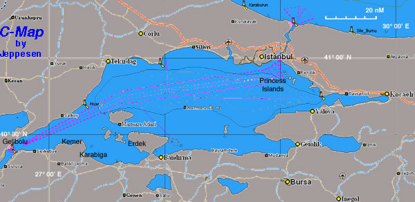

The Sea of Marmara (Turkish: Marmara Denizi, Greek: Θάλασσα του Μαρμαρά or Προποντίς, Bulgarian: Мраморно море,Hungarian: Márvány-tenger (Marble sea), also known as the Sea of Marmora or the Marmara Sea, and in the context of classical antiquity as Propontis (Greek: Προποντίς), is the inland sea that connects the Black Sea to the Aegean Sea, thus separating the Asian part of Turkey from its European part. The Bosphorus strait connects it to the Black Sea and the Dardanelles strait to the Aegean. The former also separates Istanbul into its Asian side and European side. The Sea has an area of 11,350 km2 and is about 150 nM (280 km) long and 43 nM (80 km) wide.
The salinity of the sea averages about 22 parts per thousand, which is slightly greater than that of the Black Sea but only about two-thirds that of the oceans. However, sea-bottom waters are much more saline, averaging salinities of around 38 parts per thousand — similar to that of the Mediterranean Sea. This high-density saline water, like that of the Black Sea itself, does not migrate to the surface. Water from the Granicus, Susurluk, Biga and Gonen Rivers also reduces the salinity of the sea, though with less influence than on the Black Sea. Almost all of these rivers flow from Anatolia: very little land in Thrace drains southward.
There are two major island groups known as the Prince's and Marmara islands. The latter group is rich in sources of marble and gives the sea its name (Greek marmaro, marble). A notable island located in this sea is İmralı, where Abdullah Öcalan is imprisoned.
Charts
- BA
- 224 Maramara Denizi
- 1005 Marmara Adasi to Istanbul Boğazi
- NIMA
- 55040 Sea of Marmara
- Turkey
- 29 Marmara Sea
- 291 İzmit Körfezi
- 292 İstanbul - Mudanya
- 293 Büyükçekmece - Hoşköy
- 294 Marmara Adaları - İmralı Adası
- 295 Hoşköy - Gelibolu
- 296 Marmara Adaları
- Greek
- 109 Ionio-Aegeo Steno Messinis mechri Thalassa Marmara
Weather
See Turkey.
Communication
Add here VHF channel for coastguard, harbor masters. etc.
Also see World Cruiser's Nets
The Sea of Marmara is an enclosed sea and one may be deceived into complacency, thinking that it is an easy sea to transit. The fact is that it can develop very short choppy seas which if you are going against them make a very uncomfortable and wet ride. Also the weather here can change rather abruptly and violent thunderstorms are fairly frequent during the summer resulting in very bad visibility in these waters full of large commercial shipping.
The Sea of Marmara, considering its proximity to Istanbul, is not a popular cruising ground. With the exception of an occasional regatta from Istanbul you will rarely come across another yacht.
Note, however, that during the close season for the fishing boats (May to September), many of the commercial harbours around the Sea of Marmara are filled to bursting with laid up trawlers and purse seiners. It can be difficult if not impossible to find space to moor in them during these months and a yacht is well advised to head for harbours which cater for cruising yachts, of which there are a number around the shores.
Entrance
See Turkey.
Berthing
Ordered from Dardanelles to Istanbul.
| South Coast | NorthCoast | Islands Groups |
|
Avsa |
Kemer |
Zeytinbagi |
Esenkoy or Katirli |
Yalova |
|
Guzelce Marina |
|
Princes Islands |
|
Friends
Submit details/contacts of cruiser's "friends" that can be contacted in advance or on arrival - who can offer information and assistance to our cruising "family".
Forums
List links to discussion threads on partnering forums. (see link for requirements)
Links
- Sea of Marmara at the Wikipedia
References
See Turkey.
Comments
We welcome users' contributions to the Wiki. Please click on Comments to view other users' comments, add your own personal experiences or recommend any changes to this page following your visit.
Verified by
Date of member's last visit to Sea of Marmara and this page's details validated:
- August 1999 --Istioploos

 Travels with S/Y Thetis
- May 2011 --Athene of Lymington 17:34, 28 May 2011 (BST)
- May 2013 --Monterey

| This is a usable page of the cruising guide. However, please contribute if you can to help it grow further. Click on Comments to add your personal notes on this page or to discuss its contents. Alternatively, if you feel confident to edit the page, click on the edit tab at the top and enter your changes directly. |
| |
|---|
|
Names: Lighthouse, Istioploos, Atheneoflymington, Haiqu,Monterey |