Sea of Marmara
From CruisersWiki
(→Last Visited & Details Checked (and updated here)) |
Istioploos (Talk | contribs) (Interactive Map) |
||
| Line 1: | Line 1: | ||
==Sea of Marmara== | ==Sea of Marmara== | ||
| - | An online cruising guide for yachts sailing around the Sea of Marmara. | + | An online cruising guide for yachts sailing around the Sea of Marmara in [[Turkey]]. |
| - | + | <imagemap> | |
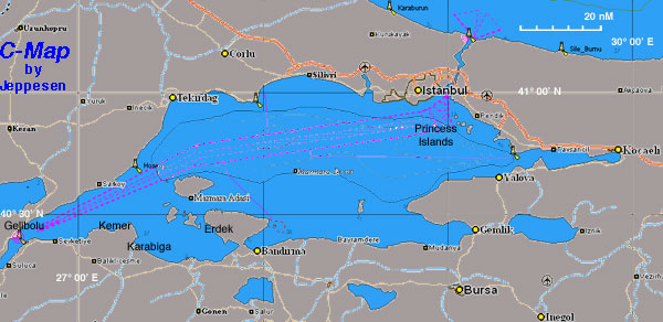
| + | Image:Turkey_Marmara_r.jpg|frame|center|<center>Chart of the Sea of Marmara - <em>For details click on a name or an area</em></center> | ||
| + | rect 87 196 120 211 [[Kemer_Sea_of_Marmara|Kemer]] | ||
| + | rect 111 216 157 235 [[Karabiga_Harbour|Karabiga]] | ||
| + | rect 183 201 214 215 [[Erdek_Harbour|Erdek]] | ||
| + | rect 228 221 279 239 [[Bandirma]] | ||
| + | rect 379 217 419 231 [[Mudanya]] | ||
| + | rect 425 200 466 218 [[Cinarcik|Çinarcik]] | ||
| + | rect 449 151 489 168 [[Yalova]] | ||
| + | rect 427 97 459 112 [[Pendik]] | ||
| + | rect 369 73 425 95 [[Istanbul]] | ||
| + | rect 85 159 117 176 [[Sarkoy|Şarköy]] | ||
| + | rect 149 79 200 99 [[Tekirdag]] | ||
| + | rect 277 57 308 77 [[Silivri]] | ||
| + | poly 154 155 195 156 229 173 229 187 181 188 181 210 147 204 145 181 [[Marmara Islands]] | ||
| + | poly 413 99 428 115 431 126 414 137 373 137 373 111 [[Princes Islands]] | ||
| + | </imagemap> | ||
{| class="infobox bordered" style="width: 28em; text-align: left; font-size: 90%;" | {| class="infobox bordered" style="width: 28em; text-align: left; font-size: 90%;" | ||
| Line 83: | Line 99: | ||
|id "North coast" valign="top" | | |id "North coast" valign="top" | | ||
| - | : [[Sarkoy]] [[Image:Harbour_icon.png]] [[image:Question_icon.png]] | + | : [[Sarkoy|Şarköy]] [[Image:Harbour_icon.png]] [[image:Question_icon.png]] |
: [[Murefte]] [[Image:Harbour_icon.png]] [[image:Anchor_Icon.png]] | : [[Murefte]] [[Image:Harbour_icon.png]] [[image:Anchor_Icon.png]] | ||
: [[Tekirdag]] [[Image:Poe.jpg]] [[Image:Harbour_icon.png]] | : [[Tekirdag]] [[Image:Poe.jpg]] [[Image:Harbour_icon.png]] | ||
Revision as of 15:14, 19 February 2015
Sea of Marmara
An online cruising guide for yachts sailing around the Sea of Marmara in Turkey.

| | |
| | 40°43′N, 28°13′E |
|---|---|
| | Photo gallery |
| | Local chartlet |
The salinity of the sea averages about 22 parts per thousand, which is slightly greater than that of the Black Sea but only about two-thirds that of the oceans. However, sea-bottom waters are much more saline, averaging salinities of around 38 parts per thousand — similar to that of the Mediterranean Sea. This high-density saline water, like that of the Black Sea itself, does not migrate to the surface. Water from the Granicus, Susurluk, Biga and Gonen Rivers also reduces the salinity of the sea, though with less influence than on the Black Sea. Almost all of these rivers flow from Anatolia: very little land in Thrace drains southward.
There are two major island groups known as the Prince's and Marmara islands. The latter group is rich in sources of marble and gives the sea its name (Greek marmaro, marble). A notable island located in this sea is İmralı, where Abdullah Öcalan is imprisoned.
Charts
- BA
- 224 Maramara Denizi
- 1005 Marmara Adasi to Istanbul Boğazi
- NIMA
- 55040 Sea of Marmara
- Turkey
- 29 Marmara Sea
- 291 İzmit Körfezi
- 292 İstanbul - Mudanya
- 293 Büyükçekmece - Hoşköy
- 294 Marmara Adaları - İmralı Adası
- 295 Hoşköy - Gelibolu
- 296 Marmara Adaları
- Greek
- 109 Ionio-Aegeo Steno Messinis mechri Thalassa Marmara
Local Radio Nets
Also see World Cruiser's Nets.
Submit details of Cruiser's Nets and VHF operating/calling channels here.
Climate & Weather
See Turkey.
Arrival/Departure procedures
See Turkey.
The Sea of Marmara is an enclosed sea and one may be deceived into complacency, thinking that it is an easy sea to transit. The fact is that it can develop very short choppy seas which if you are going against them make a very uncomfortable and wet ride. Also the weather here can change rather abruptly and violent thunderstorms are fairly frequent during the summer resulting in very bad visibility in these waters full of large commercial shipping.
The Sea of Marmara, considering its proximity to Istanbul, is not a popular cruising ground. With the exception of an occasional regatta from Istanbul you will rarely come across another yacht.
Note, however, that during the close season for the fishing boats (May to September), many of the commercial harbours around the Sea of Marmara are filled to bursting with laid up trawlers and purse seiners. It can be difficult if not impossible to find space to moor in them during these months and a yacht is well advised to head for harbours which cater for cruising yachts, of which there are a number around the shores.
Ports, Anchorages, and Islands
Ordered from Dardanelles to Istanbul.
![]() = Port of entry,
= Port of entry, ![]() = Marina,
= Marina, ![]() = Harbor,
= Harbor, ![]() = Anchorage,
= Anchorage, ![]() = Needs data.
= Needs data.
| South Coast | North coast | Islands Groups |
Routes/Passages To/From
List popular passages/routes, timing, etc.
Cruiser's Friends
Submit details/contacts of cruiser's "friends" that can be contacted in advance or on arrival - who can offer information and assistance to our cruising "family".
Forum Discussions
List links to discussion threads on partnering forums. (see link for requirements)
External Links
- Sea of Marmara (Wikipedia)
References & Publications
See Turkey.
Personal Notes
Personal experiences?
Last Visited & Details Checked (and updated here)
Date of member's visit to this Port/Stop & this page's details validated:
- August 1999 --Istioploos

- May 2011 --Athene of Lymington 17:34, 28 May 2011 (BST)
- May 2013 --Monterey

|
|---|
|
Names: Lighthouse, Istioploos, Atheneoflymington, Haiqu,Monterey |
| |
|---|
| | HOMEPAGE | Wiki Contents | Western Europe | Mediterranean | Turkey | Sea of Marmara | |