Vela Smokvica
From CruisersWiki
(→Berthing options) |
Istioploos (Talk | contribs) (Template) |
||
| (31 intermediate revisions not shown) | |||
| Line 1: | Line 1: | ||
| - | + | {{IsPartOf|Mediterranean|Adriatic Sea|Croatia|Northern Dalmatia|Kornati archipelago}} | |
| - | + | {{TOC block}} | |
| - | { | + | |
| - | + | ||
| - | + | ||
| - | | | + | |
| - | + | ||
| - | | | + | |
| - | + | ||
| - | + | ||
| - | + | ||
| - | + | ||
| - | + | ||
| - | + | ||
| - | + | ||
| - | + | ||
| - | + | ||
| - | {{ | + | |
| - | + | ||
| - | + | ||
| - | + | {{Infobox | |
| - | [[ | + | | lat= 43.72783|lon=15.47567 |
| + | | name= Vela Smokvica | ||
| + | | portofentry= | ||
| + | | containsportofentry= | ||
| + | | zoom= 14 | ||
| + | | chartlet = y | ||
| + | | image= VelaSmokvica.jpg | ||
| + | | imagetext= The inlet of U. Lojena from the N | ||
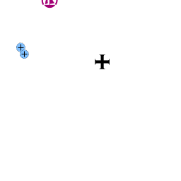
| + | | summary='''Vela Smokvica''' island lies just half a mile SE of the SE tip of the island of [[Kornat]] in the [[Kornati archipelago]] group of [[Croatia]]. Nearby alternative anchorages include [[Ravni Žakan and Kameni Žakan#Anchorages|Ravni & Kameni Žakan]] and [[Kornat#U. Opat|Opat]] on [[Kornat]]. The island has just one anchorage, the inlet of [[#U. Lojena|U. Lojena]] on its S side, which offers protection from all wind except from the southerlies. The anchorage is popular in the summer as it is the first a yacht arrives at in the approach to the Kornati Islands from S. As part of the [http://www.np-kornati.hr/en Kornati National Park], a daily permit is required to visit the island. Ashore, there are two restaurants with jetties but no other facilities. | ||
| + | |||
| + | | notes= | ||
| + | | news= | ||
| + | }} | ||
==Charts== | ==Charts== | ||
| - | + | ''See [[Northern Dalmatia#Charts|Northern Dalmatia]]''. | |
| - | + | ||
| - | + | ==Weather== | |
| - | + | ''See [[Croatia#Weather|Croatia]]''. | |
| - | + | ||
| - | + | ||
| - | + | ||
| + | ==Passages== | ||
| + | ''See [[Croatia#Passages|Croatia]]''. | ||
| - | == | + | ==Islands== |
| + | * [[Kornat]] | ||
| + | |||
| + | ==Communication== | ||
| + | {{Green|Add here VHF channel for coastguard, harbor masters. etc.}} | ||
* | * | ||
* | * | ||
| - | ''Also see [[World MM Nets|World Cruiser's Nets]]'' | + | ''Also see [[World MM Nets|World Cruiser's Nets]]'' |
| - | == | + | ==Navigation== |
| - | + | {{Green|Add any navigation notes such approaches, dangers etc here. If this section does not apply, remove it.}} | |
| - | + | ==Entrance== | |
| + | [[Zadar]] and [[Šibenik]] are the nearest all-year ports of entry. In summer only, [[Božava]] and [[Sali]] on [[Dugi Otok]] are also ports of entry. | ||
| - | + | ==Berthing== | |
| + | There is only one berthing option on the island, the inlet of [[#U. Lojena|U. Lojena]] on the S side. | ||
| - | == | + | ===Ports=== |
| - | + | None. | |
| - | == | + | ===Marinas & Yacht Clubs=== |
| - | + | None, but the [[Marina Piškera]] lies seven miles to the NW. | |
| - | + | ==Anchorages== | |
| + | {{Poi | lat= 43.72562719141111| lon= 15.477377211184997 | ||
| + | | type= buoy | ||
| + | | name= U. Lojena | ||
| + | | zoom= 17 | ||
| + | | image= VelaSmokvica2.jpg | ||
| + | | imagetext= Restaurant jetties in U. Lojena | ||
| + | | imagewidth= | ||
| + | | text= U. Lojena is located on the S side of the island, in an inlet protected from all directions except from the S. There are a few buoys deployed there. | ||
| - | + | At the head of the inlet are two restaurants with jetties, both of which have suitable depths for a yacht (but if yours has a larger draft, prefer the outer jetty). The jetties are equipped with laid moorings and concrete bollards for taking lines. Depths are 3.0 - 4.0 metres. | |
| - | + | Alternatively, anchor in the inlet in 6.0 - 8.0 metres, taking a line ashore if possible. Holding is good in sand and weed. U. Lojena is completely open to the S and should be evacuated if strong winds from that direction are forecasted. | |
| - | + | ||
| - | + | ''Konoba Piccolo'' (the one at the head of the bay) is considered to be a very good restaurant by local standards (but rather pricey). | |
| - | + | }} | |
| - | == | + | ==Amenities== |
None. | None. | ||
| - | == | + | ==Provisioning== |
| - | + | ||
| - | + | ||
| - | + | ||
| - | + | ||
| - | + | ||
| - | + | ||
| - | + | ||
None. | None. | ||
| - | == | + | ==Eating out== |
| - | '' | + | {{mark |name= ''Konoba Piccolo''| type= eatingout | text=at the head of the [[#U. Lojena|U. Lojena]] bay is considered to be a very good restaurant by local standards (but rather pricey).}} |
| - | === | + | {{mark |name= | type= eatingout | text=There is also second restaurant in [[#U. Lojena|U. Lojena]] bay.}} |
| - | + | ||
| - | == | + | ==Transportation== |
| - | + | N/A. | |
| - | == | + | ==Tourism== |
| - | + | A few cottages being occupied seasonally by fishermen or other owners from the mainland or adjoining islands. Most of the summer residents consist of the restaurant owners, the national park staff and their families. There are no restrictions on walking ashore but bear in mind that most of the land is private property. | |
| - | == | + | ==Friends== |
| - | + | ||
| - | + | ||
| - | + | ||
| - | + | ||
| - | + | ||
Contact details of "Cruiser's Friends" that can be contacted for local information or assistance. | Contact details of "Cruiser's Friends" that can be contacted for local information or assistance. | ||
* | * | ||
| - | == | + | ==Forums== |
| + | List links to discussion threads on [[Cruising Forums|partnering forums]]. (''see link for requirements'') | ||
* [http://www.cruisersforum.com/forums/tags/croatia.html Croatia Sailing and Cruising Discussions on Cruisers Forum] | * [http://www.cruisersforum.com/forums/tags/croatia.html Croatia Sailing and Cruising Discussions on Cruisers Forum] | ||
| - | * | + | * |
| - | == | + | ==Links== |
| + | * {{wikipedia|Smokvica_Vela_(Kornat)}} | ||
* [http://kornati.hr/eng/ Kornati National Park] | * [http://kornati.hr/eng/ Kornati National Park] | ||
* [http://www.about-croatia.com/croatia-marina.php List of all Croatian marinas] | * [http://www.about-croatia.com/croatia-marina.php List of all Croatian marinas] | ||
| - | |||
* [http://croatia.hr/en-GB/Homepage Croatian National Tourist Board] | * [http://croatia.hr/en-GB/Homepage Croatian National Tourist Board] | ||
* [http://www.find-croatia.com Find Croatia travel guide] | * [http://www.find-croatia.com Find Croatia travel guide] | ||
* [http://en.wikipedia.org/wiki/Croatia Wikipedia - Croatia] | * [http://en.wikipedia.org/wiki/Croatia Wikipedia - Croatia] | ||
| - | ==References | + | ==References== |
| - | ''See [[Croatia#References | + | ''See [[Croatia#References|Croatia]]''. |
| - | + | {{Comments}} | |
| - | + | * | |
* | * | ||
| - | + | {{Verified by}} | |
| - | + | ||
* July 2005 --[[User:Atheneoflymington|Athene of Lymington]] 16:20, 15 November 2012 (GMT) | * July 2005 --[[User:Atheneoflymington|Athene of Lymington]] 16:20, 15 November 2012 (GMT) | ||
| + | * June 2013 --[[User:Dimrub|Dimrub]] 17:53, 4 June 2013 (BST) | ||
| + | * | ||
| - | {{ | + | {{Page useable}} |
| - | + | ||
| - | + | ||
| - | + | ||
| - | + | ||
| - | + | ||
| - | + | ||
| - | + | ||
| - | + | ||
| - | + | ||
| - | + | ||
| - | |||
| - | |||
| - | |||
| - | |||
| - | |||
| - | |||
| + | {{Contributors|[[User:Atheneoflymington|Athene of Lymington]]}} | ||
| - | [[Category:Islands - Croatia]] | + | [[Category:Islands - Croatia]] [[Category:Anchorages - Croatia]] |
Latest revision as of 22:52, 26 March 2019
| Vela Smokvica
| |
| |
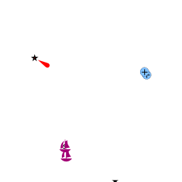
 The inlet of U. Lojena from the N |
Vela Smokvica island lies just half a mile SE of the SE tip of the island of Kornat in the Kornati archipelago group of Croatia. Nearby alternative anchorages include Ravni & Kameni Žakan and Opat on Kornat. The island has just one anchorage, the inlet of U. Lojena on its S side, which offers protection from all wind except from the southerlies. The anchorage is popular in the summer as it is the first a yacht arrives at in the approach to the Kornati Islands from S. As part of the Kornati National Park, a daily permit is required to visit the island. Ashore, there are two restaurants with jetties but no other facilities.
Charts
See Northern Dalmatia.
Weather
See Croatia.
Passages
See Croatia.
Islands
Communication
Add here VHF channel for coastguard, harbor masters. etc.
Also see World Cruiser's Nets
Add any navigation notes such approaches, dangers etc here. If this section does not apply, remove it.
Entrance
Zadar and Šibenik are the nearest all-year ports of entry. In summer only, Božava and Sali on Dugi Otok are also ports of entry.
Berthing
There is only one berthing option on the island, the inlet of U. Lojena on the S side.
Ports
None.
Marinas & Yacht Clubs
None, but the Marina Piškera lies seven miles to the NW.
Anchorages

U. Lojena
U. Lojena is located on the S side of the island, in an inlet protected from all directions except from the S. There are a few buoys deployed there.
At the head of the inlet are two restaurants with jetties, both of which have suitable depths for a yacht (but if yours has a larger draft, prefer the outer jetty). The jetties are equipped with laid moorings and concrete bollards for taking lines. Depths are 3.0 - 4.0 metres.
Alternatively, anchor in the inlet in 6.0 - 8.0 metres, taking a line ashore if possible. Holding is good in sand and weed. U. Lojena is completely open to the S and should be evacuated if strong winds from that direction are forecasted.
Konoba Piccolo (the one at the head of the bay) is considered to be a very good restaurant by local standards (but rather pricey).Amenities
None.
Provisioning
None.
Eating out
![]() Konoba Piccolo [[Vela Smokvica#Konoba Piccolo|Konoba Piccolo]] at the head of the U. Lojena bay is considered to be a very good restaurant by local standards (but rather pricey).
Konoba Piccolo [[Vela Smokvica#Konoba Piccolo|Konoba Piccolo]] at the head of the U. Lojena bay is considered to be a very good restaurant by local standards (but rather pricey).
![]() [[Vela Smokvica# | ]] There is also second restaurant in U. Lojena bay.
[[Vela Smokvica# | ]] There is also second restaurant in U. Lojena bay.
Transportation
N/A.
Tourism
A few cottages being occupied seasonally by fishermen or other owners from the mainland or adjoining islands. Most of the summer residents consist of the restaurant owners, the national park staff and their families. There are no restrictions on walking ashore but bear in mind that most of the land is private property.
Friends
Contact details of "Cruiser's Friends" that can be contacted for local information or assistance.
Forums
List links to discussion threads on partnering forums. (see link for requirements)
Links
- Vela Smokvica at the Wikipedia
- Kornati National Park
- List of all Croatian marinas
- Croatian National Tourist Board
- Find Croatia travel guide
- Wikipedia - Croatia
References
See Croatia.
Comments
We welcome users' contributions to the Wiki. Please click on Comments to view other users' comments, add your own personal experiences or recommend any changes to this page following your visit.
Verified by
Date of member's last visit to Vela Smokvica and this page's details validated:
- July 2005 --Athene of Lymington 16:20, 15 November 2012 (GMT)
- June 2013 --Dimrub 17:53, 4 June 2013 (BST)
| This is a usable page of the cruising guide. However, please contribute if you can to help it grow further. Click on Comments to add your personal notes on this page or to discuss its contents. Alternatively, if you feel confident to edit the page, click on the edit tab at the top and enter your changes directly. |
| |
|---|
|
Names: Athene of Lymington |