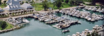
Old Bahama Bay Marina
From CruisersWiki
Old Bahama Bay Marina
| Radio | VHF channel 16, switch to 10 |
|---|---|
| Phone | ? |
| [email protected] | |
| Berths | 72 |
| Max. length | ? |
| Max. draft | ? |
| Fuel | Fuel dock |
| Water | On berth |
| Electricity | Yes, 240v/110v?? |
| Toilets | Yes |
| Showers | Yes |
| Hours | ? |
| More notes about the marina | |
Marina description...
Communication
Contact "Old Bahama Bay Marina" on VHF 16 before entry.
- Daylight approach:
- A conspicuous red and white water tower, red and green navigation lights on the end of the jetty; a 30 foot tower on port jetty.
- Night time approach:
- Excellent Red & green navigation lights visible from approximate 3-5 miles.
Berthing
After clearing, all vessels must check-in with the Dockmaster on Ch. 16 for slip assignment & register on board or at the Front Desk.
Facilities
List all the marina facilities.
Repairs
Haul-out?, yard?, etc.
Security
Describe marina security.
Marina location
Is the marina close to shops and other facilities ?
Transportation
List transportation (local and/or international. Bus service to town?)
Price
Provide price information. If possible add a link to the marina's pricing page.)
Verified by
Date of member's last visit to Old Bahama Bay Marina and this page's details validated: Date of member's visit to this marina & this page's details validated:
If you provide a lot of info and this page is almost complete, change to {{page useable}}.
| This page has an outline in place but needs completing. Please contribute if you can to help it grow further. Click on Comments to suggest further content or alternatively, if you feel confident to edit this page, click on the edit tab at the top and enter your changes directly. |
| |
|---|
|
Names: Lighthouse |
