Porto Lago
From CruisersWiki
Istioploos (Talk | contribs) (Coords & minor edits) |
Istioploos (Talk | contribs) (Added Infobox) |
||
| Line 1: | Line 1: | ||
==Porto Lago== | ==Porto Lago== | ||
| - | GPS: {{Coord|40|59.6|N|25|07.3|E|}} | + | {| class="infobox bordered" style="width: 25em; text-align: left; font-size: 85%;" |
| - | [ | + | |- |
| + | | colspan="2" style="text-align:left; font-size: smaller;" | {{Small info}} (''Click links for more information'') | ||
| + | |- | ||
| + | ! GPS: | ||
| + | | {{Coord|40|59.6|N|25|07.3|E|}} | ||
| + | |- | ||
| + | ! Gallery: | ||
| + | | [http://www.panoramio.com/map/#lt=41.000662&ln=25.124402&z=2&k=0&a=1&tab=2 Photo gallery] | ||
| + | |- | ||
| + | ! Chartlet: | ||
| + | | [http://mapserver.maptech.com/homepage/index.cfm?lat=41.00291965466167&lon=25.126453760024294&scale=20000&zoom=50&type=0&icon=0&width=498&height=498&searchscope=dom&CFID=1509264&CFTOKEN=22608242&scriptfile=http://mapserver.maptech.com/homepage/index.cfm&latlontype=DMS Local chartlet] | ||
| + | |} | ||
===Background=== | ===Background=== | ||
[http://en.wikipedia.org/wiki/Porto_Lago Porto Lago] (Πόρτο Λάγγο) is a harbor in the Vistonikos gulf in [http://en.wikipedia.org/wiki/Western_Thrace Thrace]. Lake Vistonis is a narrow strip away. This is an area with many water foul. The port is very commercial but surprisingly not unattractive, save for murky waters which give home to clouds of bloodthirsty mosquitoes. | [http://en.wikipedia.org/wiki/Porto_Lago Porto Lago] (Πόρτο Λάγγο) is a harbor in the Vistonikos gulf in [http://en.wikipedia.org/wiki/Western_Thrace Thrace]. Lake Vistonis is a narrow strip away. This is an area with many water foul. The port is very commercial but surprisingly not unattractive, save for murky waters which give home to clouds of bloodthirsty mosquitoes. | ||
| - | + | {| align="right" | |
| + | |valign="top"| | ||
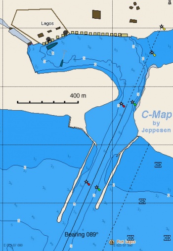
| + | [[Image:Greece_PortoLago_r.jpg|350px|thumb|right|Chart of Porto Lago Region<br/>''Click for larger view'']] | ||
| + | |} | ||
===Charts=== | ===Charts=== | ||
| - | + | ;BA | |
| - | + | :1086 Srimonikos kólpos to Edremit Körfezi | |
| - | + | ;Imray-Tetra | |
| - | + | :G2 Aegean Sea (North) | |
| - | + | ;NIMA | |
| - | + | :54360 Thessaloniki to Canakkale Bogazi Dardanelles | |
| - | + | :54363 Akra Akrathos to Dardanelles Ayio Oros | |
| - | + | ;Greek | |
| - | + | :31 North Evoikos to Kavala Gulf | |
| - | + | :32 Thrakiko Sea | |
| + | :321 Thassos, Alexandroupolis, Samothrake, Imvros | ||
===Radio Nets=== | ===Radio Nets=== | ||
| Line 28: | Line 43: | ||
===Check-in facilities=== | ===Check-in facilities=== | ||
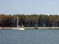
[[Image:Greece_PortoLago1.jpg|200px|thumb|right|Porto Lago near the "yachting club"<br/>''Click for larger view'']] | [[Image:Greece_PortoLago1.jpg|200px|thumb|right|Porto Lago near the "yachting club"<br/>''Click for larger view'']] | ||
| - | GPS: {{Coord|41|0.3|N|25|07.2|E|}} | + | GPS: {{Coord|41|0.3|N|25|07.2|E|}}<br/> |
The large harbor is very well protected and is an all weather shelter. One can anchor off, in 6 m depth with excellent holding in mud, but the port authorities seem to disapprove. | The large harbor is very well protected and is an all weather shelter. One can anchor off, in 6 m depth with excellent holding in mud, but the port authorities seem to disapprove. | ||
| Line 98: | Line 113: | ||
====''Last Visited & Details Checked (and updated here)''==== | ====''Last Visited & Details Checked (and updated here)''==== | ||
''Date of member's visit to this Port/Stop & this page's details validated'': | ''Date of member's visit to this Port/Stop & this page's details validated'': | ||
| - | * June 2002 --[[User:Istioploos|Istioploos]] | + | * June 2002 --[[User:Istioploos|Istioploos]] [[Image:Greece_Icon.png]] |
* | * | ||
Revision as of 18:19, 5 May 2009
Porto Lago
| | |
| GPS: | 40°59.6′N, 25°07.3′E |
|---|---|
| Gallery: | Photo gallery |
| Chartlet: | Local chartlet |
Background
Porto Lago (Πόρτο Λάγγο) is a harbor in the Vistonikos gulf in Thrace. Lake Vistonis is a narrow strip away. This is an area with many water foul. The port is very commercial but surprisingly not unattractive, save for murky waters which give home to clouds of bloodthirsty mosquitoes.
Charts
- BA
- 1086 Srimonikos kólpos to Edremit Körfezi
- Imray-Tetra
- G2 Aegean Sea (North)
- NIMA
- 54360 Thessaloniki to Canakkale Bogazi Dardanelles
- 54363 Akra Akrathos to Dardanelles Ayio Oros
- Greek
- 31 North Evoikos to Kavala Gulf
- 32 Thrakiko Sea
- 321 Thassos, Alexandroupolis, Samothrake, Imvros
Radio Nets
Also see Cruiser's Nets
- Coast Guard - VHF channel 12, Tel. +30 5350 22 222
- Olympia Radio - VHF no signal
The approach to Porto Lago is via a dredged channel in the very shallow Vistonikos gulf, it is best not to be attempted at night, although it is well marked by buoys.
Check-in facilities
GPS: 41°0.3′N, 25°07.2′E
The large harbor is very well protected and is an all weather shelter. One can anchor off, in 6 m depth with excellent holding in mud, but the port authorities seem to disapprove.
There are two other alternatives equally less attractive: dock side-to the very tall quay to the N, or dock at the two floating piers in what may be a "yachting club" on the SW which has very short and dirty laid mooring lines. It is best to anchor and come either bow or stern-to the outer pier.
Warning: There are large numbers of flies and mosquitoes here.
Tourism & things to do ashore
The lake is a short walk away across the highway. There are flamingoes, herons, storks, and other birds.
Fuel, Water, & Electricity
- Fuel - There is a fuel station on the highway, some distance from the harbor. You have to use jerry cans
- Water - N/A
- Electricity - N/A
Laundry
N/A.
Grocery & Supply Stores
Limited provision shopping.
Eateries
There is good sea food at the waterfront tavernas
Internet/WiFi
N/A.
Motorbike & Car Rentals
N/A.
Marine Stores & Facilities
There is a surprising modern looking chandlery on the highway, near the church.
Repairs
N/A.
Garbage Disposal
Trash cans.
Transportation
Buses to either Xanthi or Komotini.
Routes/Passages To/From
Popular passages/routes, timing, etc.
References & Publications
See Greece.
Cruiser's Friends
Contact details of "Cruiser's Friends" that can be contacted for local information or assistance.
Forum Discussions
List links to discussion threads on the Cruiser Log Forum
External Links
- Porto Lago (Wikipedia)
Personal Notes
Personal experiences?
Last Visited & Details Checked (and updated here)
Date of member's visit to this Port/Stop & this page's details validated:
- June 2002 --Istioploos

| |
|---|
| | HOMEPAGE | Wiki Contents | Mediterranean | Aegean Sea | Greece | Porto Lago | |
.

