Cesme
From CruisersWiki
Istioploos (Talk | contribs) m (→Charts: Cosmetic) |
Istioploos (Talk | contribs) (Reformated) |
||
| Line 1: | Line 1: | ||
==Çesme (Port of entry)== | ==Çesme (Port of entry)== | ||
| - | {| | + | {| class="infobox bordered" style="width: 33em; text-align: left; font-size: 85%;" |
|- | |- | ||
| - | | | + | | colspan="2" style="text-align:center; font-size: smaller;" | {{Small info}} (''Click links for more information'') |
| - | + | |- | |
| - | | | + | ! <center>[[image:World_icon.png]]</center> |
| - | < | + | | {{Coord|38|19.6|N|26|17.6|E|}} |
| - | === | + | |- |
| - | + | ! <center>[[image:Photo_icon.png]]</center> | |
| - | + | | [http://www.panoramio.com/map/#lt=38.341387&ln=26.305046&z=4&k=0&a=1&tab=2 Photo gallery] | |
| - | [[Image:Cesme1.jpg|200px|thumb|center|The Çesme Castle<br/>''Click for larger view'']] | + | |- |
| + | ! <center>[[image:Chart_icon.png]]</center> | ||
| + | | [http://mapserver.mytopo.com/homepage/index.cfm?lat=38.326667&lon=26.293333&scale=24000&zoom=50&type=1 Local chartlet] | ||
| + | |} | ||
| + | |||
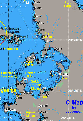
| + | [http://en.wikipedia.org/wiki/Cesme Çesme] is a small old fashion town surrounded by a region of over 1 million inhabitants, mostly in vacation homes during the summer. It is a very pleasant region because it has two openings to the sea: in the Aegean to the W and into the the Gulf of Ildir to the E. | ||
| + | |||
| + | <div style="clear: both;">[[Image:Cesme1.jpg|200px|thumb|center|The Çesme Castle<br/>''Click for larger view'']]</div> | ||
| + | |||
| + | ==Charts== | ||
| + | [[Image:Turkey_Cesme_r.jpg|350px|thumb|right|Chart of Çesme Region<br/>''Click for larger view'']] | ||
| - | |||
;BA | ;BA | ||
:1645 Nisos Chios and Izmir Körfezi | :1645 Nisos Chios and Izmir Körfezi | ||
| Line 25: | Line 34: | ||
:334 Chios Island & Opposite Coast of Asia Minor | :334 Chios Island & Opposite Coast of Asia Minor | ||
| - | + | ==Radio Nets== | |
''Also see [[HF_Radio|Cruiser's Nets]]'' | ''Also see [[HF_Radio|Cruiser's Nets]]'' | ||
Submit details of local radio Nets. | Submit details of local radio Nets. | ||
| - | + | ==Local Weather== | |
| - | + | ''See [[Turkey#Climate_&_Weather|Turkey]]''. | |
| - | ===Approach and Navigation | + | <div style="clear: both;"></div> |
| - | + | ==Approach and Navigation== | |
| - | | | + | [[Image:Turkey_Cesme_Uc.jpg|350px|thumb|right|Chart of Uç Passage - [http://mapserver.maptech.com/homepage/index.cfm?lat=38.35180615338178&lon=26.302678189764443&scale=150000&zoom=100&type=0&icon=0&width=498&height=498&searchscope=dom&CFID=1509264&CFTOKEN=22608242&scriptfile=http://mapserver.maptech.com/homepage/index.cfm&latlontype=DMS Chartlet]<br/>''Click for larger view'']] |
| + | |||
| + | Approaching the [[#Çesme_Harbor|Çesme Harbor]] from the Aegean or approaching the [[Setur_Cesme_Marina|Setur Çeşme Marina]] and other anchorages in the Gulf of Ildir from the gulf is straight forward and with out dangers but: | ||
<font color="red">Danger:</font> Care must be taken when going from the Aegean to the gulf of Ildir. There are many reefs and shallow areas. | <font color="red">Danger:</font> Care must be taken when going from the Aegean to the gulf of Ildir. There are many reefs and shallow areas. | ||
| Line 47: | Line 58: | ||
# When you are past the E point turn right and head S. | # When you are past the E point turn right and head S. | ||
| - | + | ==Check-in facilities== | |
On the Aegean side, there is the old [[#Çesme_Harbor|Çesme Harbor]] and on the Ildir side, there is the [[Setur_Cesme_Marina|Setur Çeşme Marina]] (Golden Dolphin Marina) and several small harbors which mostly cater to local boats. | On the Aegean side, there is the old [[#Çesme_Harbor|Çesme Harbor]] and on the Ildir side, there is the [[Setur_Cesme_Marina|Setur Çeşme Marina]] (Golden Dolphin Marina) and several small harbors which mostly cater to local boats. | ||
Boats checking-in or out of [[Turkey#Arrival/Departure_procedures|Turkey]] should contact the Harbor Master, Health (accross the street from the harbor), Customs, and Passport Control (on the SW entrance of the harbor). | Boats checking-in or out of [[Turkey#Arrival/Departure_procedures|Turkey]] should contact the Harbor Master, Health (accross the street from the harbor), Customs, and Passport Control (on the SW entrance of the harbor). | ||
| - | + | ||
| - | + | ==Offshore Islands== | |
| - | + | ====Kara Adasi==== | |
| + | GPS: {{Coord|38|25.5|N|26|20.6|E|}}<br /> | ||
| + | There is a possible anchorage on the S side of the island. | ||
| + | |||
| + | <font color="red">Danger:</font> There many reefs near the island. | ||
| + | |||
| + | ==Marinas & Yacht Clubs== | ||
| + | * [[Setur_Cesme_Marina|Setur Çeşme Marina]] (Golden Dolphin Marina) | ||
| + | |||
| + | ==Ports and Popular Stops== | ||
====Çesme Harbor==== | ====Çesme Harbor==== | ||
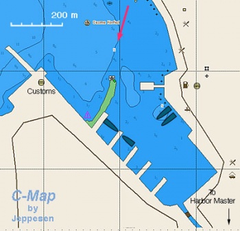
| - | + | [[Image:Turkey_Cesme_h.jpg|350px|thumb|right|Chart of Çesme Harbor<br/>''Click for larger view'']] | |
| - | | | + | |
| + | GPS: {{Coord|38|19.6|N|26|17.6|E|}}<br /> | ||
Work is almost completed on the municipal marina within the harbor. Go stern-to any of the pontoons. There are permanent moorings. | Work is almost completed on the municipal marina within the harbor. Go stern-to any of the pontoons. There are permanent moorings. | ||
| Line 66: | Line 87: | ||
=====Last Visited & Details Checked (and updated here)===== | =====Last Visited & Details Checked (and updated here)===== | ||
''Date of member's visit to this Port/Stop & this page's details validated'': | ''Date of member's visit to this Port/Stop & this page's details validated'': | ||
| - | * August 2004 --[[User:Istioploos|Istioploos]] | + | * August 2004 --[[User:Istioploos|Istioploos]] [[Image:Greece_Icon.png]] |
* | * | ||
| - | + | <div style="clear: both;"></div> | |
| - | + | ||
====Dalyan Ildur==== | ====Dalyan Ildur==== | ||
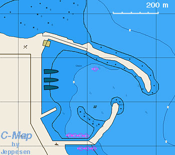
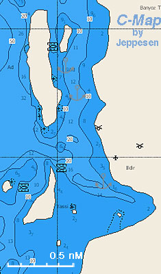
| - | + | [[Image:Turkey_Cesme_Dalyan_h.jpg|350px|thumb|right|Chart of Dalyan Ildur<br/>''Click for larger view'']] | |
| - | | | + | |
| + | GPS: {{Coord|38|21.5|N|26|19.1|E|}}<br /> | ||
A nice and well protected harbor, about 2 nM N of [[Setur_Cesme_Marina|Setur Çeşme Marina]] (Golden Dolphin) . It is operated as marina but it is almost always full by local boats. | A nice and well protected harbor, about 2 nM N of [[Setur_Cesme_Marina|Setur Çeşme Marina]] (Golden Dolphin) . It is operated as marina but it is almost always full by local boats. | ||
=====Last Visited & Details Checked (and updated here)===== | =====Last Visited & Details Checked (and updated here)===== | ||
''Date of member's visit to this Port/Stop & this page's details validated'': | ''Date of member's visit to this Port/Stop & this page's details validated'': | ||
| - | * July 2002 --[[User:Istioploos|Istioploos]] | + | * July 2002 --[[User:Istioploos|Istioploos]] [[Image:Greece_Icon.png]] |
* | * | ||
| - | |||
| - | |||
| + | <div style="clear: both;"></div> | ||
====Ilica==== | ====Ilica==== | ||
| - | + | [[Image:Turkey_Cesme_Ilica_h.jpg|350px|thumb|right|Chart of Ilica - [http://mapserver.maptech.com/homepage/index.cfm?lat=38.311667&lon=26.361667&scale=150000&zoom=100&type=0&icon=0&searchscope=dom&CFID=1509264&CFTOKEN=22608242&scriptfile=http://mapserver.maptech.com/homepage/index.cfm&latlontype=DMS Chartlet]<br/>''Click for larger view'']] | |
| - | | | + | |
| + | GPS: {{Coord|38|18.7|N|26|21.7|E|}}<br /> | ||
This is a small harbor about 1 nM S of [[Setur_Cesme_Marina|Setur Çeşme Marina]] (Golden Dolphin). It is used mainly by small local boats. | This is a small harbor about 1 nM S of [[Setur_Cesme_Marina|Setur Çeşme Marina]] (Golden Dolphin). It is used mainly by small local boats. | ||
| - | |||
| - | |||
| - | === | + | <div style="clear: both;"></div> |
| - | + | ==Anchorages== | |
| + | ====Egri Liman==== | ||
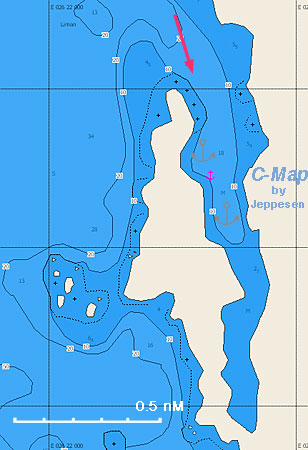
| + | [[Image:Turkey_Cesme_Egri_m.jpg|350px|thumb|right|Chart of Egri Liman - [http://mapserver.maptech.com/homepage/index.cfm?lat=38.539106949056446&lon=26.37759104424089&scale=15000&zoom=50&type=0&icon=0&width=498&height=498&searchscope=dom&CFID=1509264&CFTOKEN=22608242&scriptfile=http://mapserver.maptech.com/homepage/index.cfm&latlontype=DMS Chartlet]<br/>''Click for larger view'']] | ||
| - | + | GPS: {{Coord|38|32.6|N|26|22.5|E|}}<br /> | |
| - | + | ||
| - | + | ||
| - | + | ||
Egri Liman is a delightful small gulf with several anchorage. There is very good shelter from most winds including the ''meltem''. Anchor on the W side. The bottom is mud and weed and there may be some difficulty. | Egri Liman is a delightful small gulf with several anchorage. There is very good shelter from most winds including the ''meltem''. Anchor on the W side. The bottom is mud and weed and there may be some difficulty. | ||
| Line 103: | Line 121: | ||
=====Last Visited & Details Checked (and updated here)===== | =====Last Visited & Details Checked (and updated here)===== | ||
''Date of member's visit to this Port/Stop & this page's details validated'': | ''Date of member's visit to this Port/Stop & this page's details validated'': | ||
| - | * June 1993 --[[User:Istioploos|Istioploos]] | + | * June 1993 --[[User:Istioploos|Istioploos]] [[Image:Greece_Icon.png]] |
* | * | ||
| - | + | <div style="clear: both;"></div> | |
| - | + | ||
====Ildir==== | ====Ildir==== | ||
[[Image:Turkey_Cesme_Ildir_m.jpg|350px|thumb|right|Chart of Ildir - [http://mapserver.maptech.com/homepage/index.cfm?lat=38.4&lon=26.466667&scale=150000&zoom=100&type=0&icon=0&searchscope=dom&CFID=1509264&CFTOKEN=22608242&scriptfile=http://mapserver.maptech.com/homepage/index.cfm&latlontype=DMS Chartlet]<br/>''Click for larger view'']] | [[Image:Turkey_Cesme_Ildir_m.jpg|350px|thumb|right|Chart of Ildir - [http://mapserver.maptech.com/homepage/index.cfm?lat=38.4&lon=26.466667&scale=150000&zoom=100&type=0&icon=0&searchscope=dom&CFID=1509264&CFTOKEN=22608242&scriptfile=http://mapserver.maptech.com/homepage/index.cfm&latlontype=DMS Chartlet]<br/>''Click for larger view'']] | ||
| - | GPS: {{Coord|38|24|N|26|28|E|}}<br/> | + | |
| + | GPS: {{Coord|38|24|N|26|28|E|}}<br /> | ||
An attractive anchorage [38° 24' N 26° 28' E]. Anchor behind the island or W of the village. There are several good restaurants ashore specializing in fresh fish. The water here is not very clean, being polluted b y the many fish farms. | An attractive anchorage [38° 24' N 26° 28' E]. Anchor behind the island or W of the village. There are several good restaurants ashore specializing in fresh fish. The water here is not very clean, being polluted b y the many fish farms. | ||
=====Last Visited & Details Checked (and updated here)===== | =====Last Visited & Details Checked (and updated here)===== | ||
''Date of member's visit to this Port/Stop & this page's details validated'': | ''Date of member's visit to this Port/Stop & this page's details validated'': | ||
| - | * August 2004 --[[User:Istioploos|Istioploos]] | + | * August 2004 ---[[User:Istioploos|Istioploos]] [[Image:Greece_Icon.png]] |
* | * | ||
| - | == | + | ==Yacht Repairs and Services== |
| - | ==== | + | ====Marine Stores==== |
| - | + | At the [[Setur_Cesme_Marina|Setur Çeşme Marina]] (Golden Dolphin) and in the town of Çesme. | |
| - | + | ||
| - | + | ====Repairs/Yards==== | |
| + | In the [[Setur_Cesme_Marina|Setur Çeşme Marina]]. | ||
| - | === | + | ====Fuel, Water, & Electricity==== |
| - | + | ; Fuel | |
| + | : In the [[Setur_Cesme_Marina|Setur Çeşme Marina]] (Golden Dolphin Marina) | ||
| + | : A mini tank will deliver in the [[#Çesme_Harbor|Çesme Harbor]] | ||
| + | ; Water | ||
| + | : On the dock in [[Setur_Cesme_Marina|Setur Çeşme Marina]] (Golden Dolphin) | ||
| + | : On the dock in [[#Çesme_Harbor|Çesme Harbor]] | ||
| + | : On the dock in [[#Dalyan_Ildur|Dalyan Ildur]] | ||
| + | ; Electricity | ||
| + | : On the dock in [[Setur_Cesme_Marina|Setur Çeşme Marina]] (Golden Dolphin) | ||
| + | : On the dock in [[#Çesme_Harbor|Çesme Harbor]] | ||
| + | : On the dock in [[#Dalyan_Ildur|Dalyan Ildur]] | ||
| - | + | ==Tourism and Things to do Ashore== | |
| + | ===Tourism=== | ||
Other than the local area which has many pleasant day anchorages, one can visit [[Izmir]] about 1 hour by car. | Other than the local area which has many pleasant day anchorages, one can visit [[Izmir]] about 1 hour by car. | ||
| Line 134: | Line 163: | ||
The restored Greek village of [http://en.wikipedia.org/wiki/Alaçatı Alaçatı] is very upscale and has many fashionable stores and restaurants. | The restored Greek village of [http://en.wikipedia.org/wiki/Alaçatı Alaçatı] is very upscale and has many fashionable stores and restaurants. | ||
| - | |||
| - | |||
| - | |||
| - | |||
| - | |||
| - | |||
| - | |||
| - | |||
===Grocery & Supply Stores=== | ===Grocery & Supply Stores=== | ||
| Line 152: | Line 173: | ||
===Internet/WiFi=== | ===Internet/WiFi=== | ||
| + | In the [[Setur_Cesme_Marina|Setur Çeşme Marina]] (Golden Dolphin). | ||
| + | |||
| + | ===Laundry=== | ||
In the [[Setur_Cesme_Marina|Setur Çeşme Marina]] (Golden Dolphin). | In the [[Setur_Cesme_Marina|Setur Çeşme Marina]] (Golden Dolphin). | ||
| Line 157: | Line 181: | ||
Cars in Çesme and at the [[Setur_Cesme_Marina|Setur Çeşme Marina]] (Golden Dolphin). | Cars in Çesme and at the [[Setur_Cesme_Marina|Setur Çeşme Marina]] (Golden Dolphin). | ||
| - | === | + | ===Garbage Disposal=== |
| - | + | There are bins in all harbors and most anchorages. | |
| - | + | ||
| - | + | ||
| - | + | ||
===Transportation=== | ===Transportation=== | ||
| Line 168: | Line 189: | ||
* Izmir Airport is 95 km away | * Izmir Airport is 95 km away | ||
| - | == | + | ==Routes/Passages To/From== |
| - | See [[ | + | ''See [[Aegean_Sea#Passages|Aegean_Sea]]''. |
| - | + | ==Cruiser's Friends== | |
Contact details of "Cruiser's Friends" that can be contacted for local information or assistance. | Contact details of "Cruiser's Friends" that can be contacted for local information or assistance. | ||
| - | + | ==Forum Discussions== | |
List links to discussion threads on the Cruiser Log Forum | List links to discussion threads on the Cruiser Log Forum | ||
* | * | ||
| Line 180: | Line 201: | ||
* | * | ||
| - | + | ==External Links== | |
* [http://en.wikipedia.org/wiki/Cesme Çesme] (Wikipedia) | * [http://en.wikipedia.org/wiki/Cesme Çesme] (Wikipedia) | ||
* | * | ||
* | * | ||
| - | == | + | ==References & Publications== |
| - | + | ''See [[Turkey#References_&_Publications| Turkey]]''. | |
| - | + | ==Last Visited & Details Checked (and updated here)== | |
See individual ports in this page. | See individual ports in this page. | ||
| + | |||
| + | |||
| + | ==Personal Notes== | ||
| + | Personal experiences? | ||
| + | * | ||
| Line 201: | Line 227: | ||
|} | |} | ||
| + | |||
| + | [[Category:Ports - Turkey]] | ||
| + | |||
| + | |||
. | . | ||
Revision as of 10:39, 15 May 2010
Çesme (Port of entry)
| | |
| | 38°19.6′N, 26°17.6′E |
|---|---|
| | Photo gallery |
| | Local chartlet |
Çesme is a small old fashion town surrounded by a region of over 1 million inhabitants, mostly in vacation homes during the summer. It is a very pleasant region because it has two openings to the sea: in the Aegean to the W and into the the Gulf of Ildir to the E.
Charts
- BA
- 1645 Nisos Chios and Izmir Körfezi
- Imray-Tetra
- G28 Nísos Khíos & the Coast of Turkey
- G32 Eastern Sporades, Dodecanese & the Coast of Turkey
- NIMA
- 54389 Fener Adasi to Samos Strait
- Turkey
- 2223 Gerence - Ildır Körfezi
- 2224 Süngükaya Geçidi
- Greek
- 334 Chios Island & Opposite Coast of Asia Minor
Radio Nets
Also see Cruiser's Nets
Submit details of local radio Nets.
Local Weather
See Turkey.
Approaching the Çesme Harbor from the Aegean or approaching the Setur Çeşme Marina and other anchorages in the Gulf of Ildir from the gulf is straight forward and with out dangers but:
Danger: Care must be taken when going from the Aegean to the gulf of Ildir. There are many reefs and shallow areas.
The Uç Burunlar Passage
Going through the tricky Uç Burunlar Passage saves time and distance. At first glance, it seems hopeless because many of the reefs are just below the surface and are very hard to see. The trick is to move very slowly and carefully along an S shaped course. From Çesme to the Gulf of Ildir proceed as follows:
- Head N towards Toprak Adasi
- When you are half way between Toprak Adasi and Uç Burunlar Point turn right heading E
- After coming abreast of Uç Burunlar Point turn right and head SE
- When your abreast the middle of the cove to your S turn left heading NE
- When you are past the E point turn right and head S.
Check-in facilities
On the Aegean side, there is the old Çesme Harbor and on the Ildir side, there is the Setur Çeşme Marina (Golden Dolphin Marina) and several small harbors which mostly cater to local boats.
Boats checking-in or out of Turkey should contact the Harbor Master, Health (accross the street from the harbor), Customs, and Passport Control (on the SW entrance of the harbor).
Offshore Islands
Kara Adasi
GPS: 38°25.5′N, 26°20.6′E
There is a possible anchorage on the S side of the island.
Danger: There many reefs near the island.
Marinas & Yacht Clubs
- Setur Çeşme Marina (Golden Dolphin Marina)
Ports and Popular Stops
Çesme Harbor
GPS: 38°19.6′N, 26°17.6′E
Work is almost completed on the municipal marina within the harbor. Go stern-to any of the pontoons. There are permanent moorings.
Camper and Nicholsons have now the management of the marina and there is hope that it will be operating soon with full services. For information sent Email or call +90 232 712 99 13.
Bavaria Yachts, a local dealer and a charter company operates in a small area on the quay. Mr. Tener Gümüs, the director, is very friendly and kind.
Last Visited & Details Checked (and updated here)
Date of member's visit to this Port/Stop & this page's details validated:
- August 2004 --Istioploos

Dalyan Ildur
GPS: 38°21.5′N, 26°19.1′E
A nice and well protected harbor, about 2 nM N of Setur Çeşme Marina (Golden Dolphin) . It is operated as marina but it is almost always full by local boats.
Last Visited & Details Checked (and updated here)
Date of member's visit to this Port/Stop & this page's details validated:
- July 2002 --Istioploos

Ilica
GPS: 38°18.7′N, 26°21.7′E
This is a small harbor about 1 nM S of Setur Çeşme Marina (Golden Dolphin). It is used mainly by small local boats.
Anchorages
Egri Liman
GPS: 38°32.6′N, 26°22.5′E
Egri Liman is a delightful small gulf with several anchorage. There is very good shelter from most winds including the meltem. Anchor on the W side. The bottom is mud and weed and there may be some difficulty.
Danger: There are several reefs in the area.
Last Visited & Details Checked (and updated here)
Date of member's visit to this Port/Stop & this page's details validated:
- June 1993 --Istioploos

Ildir
GPS: 38°24′N, 26°28′E
An attractive anchorage [38° 24' N 26° 28' E]. Anchor behind the island or W of the village. There are several good restaurants ashore specializing in fresh fish. The water here is not very clean, being polluted b y the many fish farms.
Last Visited & Details Checked (and updated here)
Date of member's visit to this Port/Stop & this page's details validated:
- August 2004 ---Istioploos

Yacht Repairs and Services
Marine Stores
At the Setur Çeşme Marina (Golden Dolphin) and in the town of Çesme.
Repairs/Yards
In the Setur Çeşme Marina.
Fuel, Water, & Electricity
- Fuel
- In the Setur Çeşme Marina (Golden Dolphin Marina)
- A mini tank will deliver in the Çesme Harbor
- Water
- On the dock in Setur Çeşme Marina (Golden Dolphin)
- On the dock in Çesme Harbor
- On the dock in Dalyan Ildur
- Electricity
- On the dock in Setur Çeşme Marina (Golden Dolphin)
- On the dock in Çesme Harbor
- On the dock in Dalyan Ildur
Tourism and Things to do Ashore
Tourism
Other than the local area which has many pleasant day anchorages, one can visit Izmir about 1 hour by car.
A visit to Çeşme Castle and its museum (08:30 and 17:00) is worthwhile.
The restored Greek village of Alaçatı is very upscale and has many fashionable stores and restaurants.
Grocery & Supply Stores
- Excellent shopping in the town
- Mini-market in Setur Çeşme Marina (Golden Dolphin)
Eateries
- Good food at numerous restaurants especially in Dalyan Ildur
- Also, good food at the fashionable and upscale Alaçatı
Internet/WiFi
In the Setur Çeşme Marina (Golden Dolphin).
Laundry
In the Setur Çeşme Marina (Golden Dolphin).
Motorbike & Car Rentals
Cars in Çesme and at the Setur Çeşme Marina (Golden Dolphin).
Garbage Disposal
There are bins in all harbors and most anchorages.
Transportation
Routes/Passages To/From
See Aegean_Sea.
Cruiser's Friends
Contact details of "Cruiser's Friends" that can be contacted for local information or assistance.
Forum Discussions
List links to discussion threads on the Cruiser Log Forum
External Links
- Çesme (Wikipedia)
References & Publications
See Turkey.
Last Visited & Details Checked (and updated here)
See individual ports in this page.
Personal Notes
Personal experiences?
| |
|---|
| | HOMEPAGE | Wiki Contents | Mediterranean | Aegean Sea | Turkey | Cesme | |
.

