Kythnos
From CruisersWiki
m (→Loutra) |
|||
| Line 1: | Line 1: | ||
| - | ==Kythnos== | + | == Kythnos == |
| - | {| | + | |
| + | {| style="text-align: left; width: 28em; font-size: 90%" class="infobox bordered FCK__ShowTableBorders" | ||
|- | |- | ||
| - | | | + | | style="text-align: center; font-size: smaller" colspan="2" | {{Small info}} (''Click links for more information'') |
|- | |- | ||
| - | ! <center>[[ | + | ! <center>[[Image:World icon.png]]</center> |
| {{Coord|37|23.5|N|24|23.7|E|}} | | {{Coord|37|23.5|N|24|23.7|E|}} | ||
|- | |- | ||
| - | ! <center>[[ | + | ! <center>[[Image:Photo icon.png]]</center> |
| [http://www.panoramio.com/map/#lt=37.368520&ln=24.421234&z=6&k=0&a=1&tab=2 Photo gallery] | | [http://www.panoramio.com/map/#lt=37.368520&ln=24.421234&z=6&k=0&a=1&tab=2 Photo gallery] | ||
|- | |- | ||
| - | ! <center>[[ | + | ! <center>[[Image:Chart icon.png]]</center> |
| [http://mapserver.mytopo.com/homepage/index.cfm?lat=37.3577825736&lon=24.3832627635&scale=150000&zoom=50&type=0&height=498&width=498&icon=0&searchscope=dom&CFID=17583484&CFTOKEN=79232580&scriptfile=http://mapserver.mytopo.com/homepage/index.cfm&bpid=MAP0204021051&latlontype=DMS Local chartlet] | | [http://mapserver.mytopo.com/homepage/index.cfm?lat=37.3577825736&lon=24.3832627635&scale=150000&zoom=50&type=0&height=498&width=498&icon=0&searchscope=dom&CFID=17583484&CFTOKEN=79232580&scriptfile=http://mapserver.mytopo.com/homepage/index.cfm&bpid=MAP0204021051&latlontype=DMS Local chartlet] | ||
|} | |} | ||
| - | The island of [http://en.wikipedia.org/wiki/Kythnos Kythnos] (Κύθνος) or Kithnos | + | The island of [http://en.wikipedia.org/wiki/Kythnos Kythnos] (Κύθνος) or Kithnos or Thermia (Θερμιά) lies at the western end of the Cyclades group of islands in Greece, 30 miles due S of the large island of Evia and 25 miles SE of Cape Sounion at the NE limit of the Saronic Gulf. The island is a popular port of call for yachts sailing down from the harbours around Athens or from Lavrio in the Evia Channel and a regular stopping off point for yachts transiting the Corinth Canal. There are two main harbours on the island, the main ferry harbour of Merikas on the W coast (which is not particularly yacht friendly) and the popular harbour of Loutra on the NE coast, which regularly accommodates up to 20 or so yachts on passage through the Cyclades. There are also a number of lovely anchorages on both the E and W coast of the island which can be used in the appropriate wind conditions. Kythnos is at the western fringe of the prevailing Aegean weather system and does not normally experience quite the same wind strengths as the islands further east. |
| - | {{TOCleft}} | + | {{TOCleft}} |
| - | + | ||
| - | + | ||
| - | ;BA | + | == Charts == |
| - | :1038 Stenó Sífnou to Stenó Kafiréa | + | |
| - | ;Imray-Tetra | + | [[Image:Kithnos m.jpg|thumb|350px|Kithnos m.jpg]] |
| - | :G31 North Cyclades | + | |
| - | ;NIMA | + | ;BA |
| - | :54320 Cyclades to Crete | + | :1038 Stenó Sífnou to Stenó Kafiréa |
| - | ;Greek | + | ;Imray-Tetra |
| + | :G31 North Cyclades | ||
| + | ;NIMA | ||
| + | :54320 Cyclades to Crete | ||
| + | ;Greek | ||
:421 Karystos to Naxos | :421 Karystos to Naxos | ||
| - | ==Radio Nets== | + | == Radio Nets == |
| - | + | ||
| - | + | ''Also see [[HF Radio|Cruiser's Nets]]'' | |
| - | + | ||
| - | + | *Coast Guard - VHF channel 12 | |
| - | + | *Olympia Radio - VHF channel 27; No reception in [[#Fikiadha|Fikiadha]] and [[#Kolimpithres|Kolimpithres]] | |
| - | == | + | == Weather == |
| - | + | ||
| - | + | ''See [[Aegean Sea#Weather_and_Winds|Aegean Sea]]''. | |
| - | + | ||
| - | == | + | == Approach and Navigation == |
| - | + | ||
| - | + | ||
| - | + | ||
| - | + | ||
| - | + | See entries for individual harbours and anchorages. | |
| - | + | == Check-in facilities == | |
| - | + | There is no port of entry on Kythnos. The nearest ports of entry are [[Ermoupolis]] on [[Syros]] to the E and [[Lavrion]] or the marinas around Athene to the N and W. | |
| - | + | ||
| - | + | ||
| - | + | ||
| - | ==== | + | == Ports and Popular Stops == |
| - | + | ||
| - | + | ||
| - | + | ||
| - | + | === Ports === | |
| - | + | ||
| - | + | ==== Merikas ==== | |
| - | + | [[Image:World icon.png]] {{Coord|37|23.5|N|24|23.7|E|}} - [http://mapserver.maptech.com/homepage/index.cfm?lat=37.391667&lon=24.395&scale=24000&zoom=50&type=1 Chartlet]<br>The harbour of Merikas lies on the W side of the island, five miles S of the cape of Ak Kefalos at its northern tip. The main harbour used by the ferry boats, Merikas lies at the SE end of the bay of the same name and offers reasonable protection from the ''meltemi'', which mainly gusts here from the NE. Visiting yachts can moor stern/bows to the quay (or even alongside in quiet periods) SE of the short ferry jetty, where depths are 3.0 – 5.0 metres and the holding good in sand and mud. Shelter is good in the prevailing NE winds, which blow a yacht off the quay, but poor with anything W in the wind. Strong westerlies would probably make the harbour untenable. The surroundings here are not very attractive, but Merikas is a useful port of call when strong NE winds make a passage round Ak Kefalos challenging. | |
| - | = | + | <font color="#ff0000">Warning:</font> Be aware that there can be substantial prop wash down the quayside from ferries when leaving which can, in extreme cases, cause damage to yacht mooring lines, fairleads and cleats. |
| - | + | ||
| - | + | ||
| - | + | ||
| - | + | There are several tavernas and a minimarket ashore. Buses go from here regularly to the Chora two miles uphill to the NE | |
| - | + | ||
| - | + | ||
| - | + | ||
| - | + | ||
| - | =====Last Visited & Details Checked (and updated here)===== | + | ===== Last Visited & Details Checked (and updated here) ===== |
| - | ''Date of member's visit to this Port/Stop & this page's details validated'': | + | |
| - | * May 2010 --[[User:Istioploos|Istioploos]] [[Image: | + | ''Date of member's visit to this Port/Stop & this page's details validated'': |
| - | * | + | |
| - | <center><gallery | + | *1988 --[[User:Istioploos|Istioploos]] [[Image:Greece Icon.png]] |
| + | *September 2011 --[[User:Atheneoflymington|Athene of Lymington]] 16:28, 6 September 2011 (BST) | ||
| + | |||
| + | ==== Loutra ==== | ||
| + | |||
| + | [[Image:Greece Kythnos Loutra r.jpg|thumb|right|330px|Greece Kythnos Loutra r.jpg]] [[Image:LoutraHarbour.jpg|thumb|right|330px|LoutraHarbour.jpg]] [[Image:LoutraNEQuay.jpg|thumb|right|330px|LoutraNEQuay.jpg]] | ||
| + | |||
| + | [[Image:World icon.png]] {{Coord|37|26.6|N|24|25.9|E|}}<br>The harbour of Loutra (Λουτρά) is on the NE side of the island and is somewhat more yacht-friendly than the main ferry harbour. Although the prevailing NE winds blow down into the bay and cause a pronounced swell, the harbour, situated at the extreme W end of the bay, escapes much of the worst. The harbour is defined by a long NE breakwater with an L-shaped extension and, on the SW side, by a short jetty filled with local small craft. It is quite small, and yachts are advised to prepare anchors, lines and fenders before entering in view of the limited space to manoeuvre. Yachts can moor in one of three positions: stern/bows-to the quay of the NE breakwater using their anchors, where there is space for around 12 yachts; alongside the inside of the L-shaped extension, where there is space for two yachts; or alongside the outside of this extension, where there is room for four yachts. The last position experiences some swell with strong NE winds and is very uncomfortable in gales from this direction. The remaining positions afford very good shelter in all winds. There are plentiful water and electricity points along the quays. | ||
| + | |||
| + | An alternative if the harbour is full is the anchorage of Ay Irini, a deep inlet at the SE end of the bay. A yacht can anchor here in 3.0 – 5.0 metres and take a line ashore to rings in the rocks on the N side of the inlet. Shelter here is reasonably good in moderate winds, though a swell comes in with strong NE winds. | ||
| + | |||
| + | In the town are the main hot springs from which Kea derives its alternative name of Thermia. There are several tavernas around the harbour, a couple of good minimarkets in the village and car and scooter rental can be arranged. | ||
| + | |||
| + | ===== Last Visited & Details Checked (and updated here) ===== | ||
| + | |||
| + | ''Date of member's visit to this Port/Stop & this page's details validated'': | ||
| + | |||
| + | *May, 2010 --[[User:Istioploos|Istioploos]] [[Image:Greece Icon.png]] | ||
| + | *September 2011 --[[User:Atheneoflymington|Athene of Lymington]] 16:28, 6 September 2011 (BST) | ||
| + | |||
| + | === Anchorages === | ||
| + | |||
| + | ==== Fikiadha[[Image:Greece Kythnos Fikiada h.jpg|thumb|right|330px|Greece Kythnos Fikiada h.jpg]] ==== | ||
| + | |||
| + | ==== [[Image:World icon.png]] {{Coord|37|24.7|N|24|23|E|}} ==== | ||
| + | |||
| + | Fikiadha (Φικιάδα) is a beautiful anchorage, and is very well protected from both the ''meltemi'' and southerlies. Depending on the prevailing wind, anchor either on the N or S side of the little cove. Be careful, because there is weed at the bottom and sometimes anchors give the appearance of having caught but come undone when strained by a strong gust. Always check the anchor by snorkeling. If the anchorage is full, you can drop your anchor near the NW and take a line to the N shore. There is now a restaurant over the sandbar. Its food is of an indifferent quality. | ||
| + | |||
| + | ===== Last Visited & Details Checked (and updated here) ===== | ||
| + | |||
| + | ''Date of member's visit to this Port/Stop & this page's details validated'': | ||
| + | |||
| + | *May 2010 --[[User:Istioploos|Istioploos]] [[Image:Greece Icon.png]] | ||
| + | * | ||
| + | <center><gallery perrow="3" widths="250px"> | ||
Image:Greece_Kythnos_a.jpg|Aerial View of Fikiadha & Kolimpithres<br/>''Click for larger view'' | Image:Greece_Kythnos_a.jpg|Aerial View of Fikiadha & Kolimpithres<br/>''Click for larger view'' | ||
Image:Kythnos_Fikiada2.jpg|The Sandbar in Fikiadha<br/>''Click for larger view'' | Image:Kythnos_Fikiada2.jpg|The Sandbar in Fikiadha<br/>''Click for larger view'' | ||
Image:Kythnos_Fikiada1.jpg|Fikiadha from the E<br/>''Click for larger view'' | Image:Kythnos_Fikiada1.jpg|Fikiadha from the E<br/>''Click for larger view'' | ||
</gallery></center> | </gallery></center> | ||
| + | ==== Kolimpithres ==== | ||
| - | ==== | + | ==== [[Image:Greece Kythnos Kolona h.jpg|thumb|right|330px|Greece Kythnos Kolona h.jpg]] [[Image:World icon.png]] {{Coord|37|24.9|N|24|22|E|}} ==== |
| - | [[Image: | + | |
| - | [[ | + | |
| - | + | ||
| - | + | ||
| - | + | Kolimpithres or Kolona is E of the sand bar which separates it from Fikiada is also a very attractive anchorage. It is very well protected from both the ''meltemi'' and southerlies. On a small beach on the N side of the cove, there is a hot spring in the shape of a small bathtub where you can relax. Unfortunately, it is very popular with motor cruisers from Athens during the summer weekends. Anchor to the S and take a line to a rock on the N shore. The bottom is weed and not always good holding. Drop the anchor on a sandy patch and always check the anchor by snorkeling. [[Image:Kythnos Kolona1.jpg|thumb|right|330px|Kythnos Kolona1.jpg]] | |
| - | + | ||
| - | + | ||
| - | + | ||
| - | ==== | + | ===== Last Visited & Details Checked (and updated here) ===== |
| - | + | ||
| - | + | ||
| - | + | ||
| - | + | ||
| - | + | ''Date of member's visit to this Port/Stop & this page's details validated'': | |
| - | ''Date of member's visit to this Port/Stop & this page's details validated'': | + | |
| - | + | ||
| - | + | ||
| - | + | *May 2010 --[[User:Istioploos|Istioploos]] [[Image:Greece Icon.png]] | |
| - | [[ | + | * |
| - | [[ | + | |
| - | + | ||
| - | ==== | + | ==== Apokrousis[[Image:Greece Kythnos Apokrisis h.jpg|thumb|right|330px|Greece Kythnos Apokrisis h.jpg]] ==== |
| - | + | ||
| - | + | ||
| - | + | ||
| - | ==== | + | ==== [[Image:World icon.png]] {{Coord|37|24.8|N|24|23.8|E|}} ==== |
| - | [[ | + | |
| - | + | ||
| - | + | This cove is just E of Fikiada (sometimes it is referred as Apokrisis or Apokriosis). It is well protected. Be careful, because there is weed at the bottom and sometimes anchors give the appearance of having caught but come undone when strained by a strong gust. Anchor in 4.0 metres and check the anchor by snorkeling. [[Image:Kythnos Apokrisis.jpg|thumb|right|310px|Kythnos Apokrisis.jpg]] | |
| - | [[ | + | |
| - | + | ||
| - | ==== | + | ===== Last Visited & Details Checked (and updated here) ===== |
| - | + | ||
| - | + | ||
| - | + | ''Date of member's visit to this Port/Stop & this page's details validated'': | |
| - | ''Date of member's visit to this Port/Stop & this page's details validated'': | + | |
| - | + | ||
| - | + | ||
| - | + | *June, 2003 --[[User:Istioploos|Istioploos]] [[Image:Greece Icon.png]] | |
| - | + | * | |
| - | == | + | ==== Ayios Stefanos & Ayios Ioannis[[Image:Kythnos AyIoannis2.jpg|thumb|right|321px|Kythnos AyIoannis2.jpg]] ==== |
| - | ==== | + | |
| - | + | ||
| - | ==== | + | [[Image:World icon.png]] {{Coord|37|23.3|N|24|27.9|E|}} - [http://mapserver.maptech.com/homepage/index.cfm?lat=37.394100436703056&lon=24.46279077377787&scale=20000&zoom=50&type=0&icon=0&width=498&height=498&searchscope=dom&CFID=1509264&CFTOKEN=22608242&scriptfile=http://mapserver.maptech.com/homepage/index.cfm&latlontype=DMS Chartlet]<br>These two bays are on the E coast of the island. They provide good shelter from the ''meltemi''. |
| - | + | ||
| - | ==== | + | ===== Last Visited & Details Checked (and updated here) ===== |
| - | + | ||
| - | + | ||
| - | + | ||
| - | + | ||
| - | + | ||
| - | + | ||
| - | + | ''Date of member's visit to this Port/Stop & this page's details validated'': | |
| - | + | ||
| - | + | ||
| - | + | *September 2000 --[[User:Istioploos|Istioploos]] [[Image:Greece Icon.png]] | |
| - | + | * | |
| - | + | ||
| - | [[ | + | |
| - | + | ||
| - | + | ||
| - | * | + | |
| - | === | + | ==== Episkopis ==== |
| - | + | ||
| - | + | [[Image:World icon.png]] {{Coord|37|24.1|N|24|23.6|E|}} - [http://mapserver.maptech.com/homepage/index.cfm?lat=37.401667&lon=24.393333&scale=24000&zoom=50&type=1 Chartlet]<br>Open to the W. Swell enters with the ''meltemi''. Good only in calm weather. | |
| - | + | ||
| - | + | ||
| - | + | ||
| - | === | + | ==== Kanala ==== |
| - | + | ||
| - | ===Laundry=== | + | [[Image:World icon.png]] {{Coord|37|20.5|N|24|26.1|E|}}<br>Open to the SE. Not very good shelter from the ''meltemi''. Good only in calm weather. |
| - | * | + | |
| + | ==== Ayios Nikolaos ==== | ||
| + | |||
| + | [[Image:World icon.png]] {{Coord|37|18.8|N|24|24.3|E|}}<br>Nice cove. Open to the SE. Not very good shelter from the ''meltemi''. Good only in calm weather. | ||
| + | |||
| + | ===== Last Visited & Details Checked (and updated here) ===== | ||
| + | |||
| + | ''Date of member's visit to this Port/Stop & this page's details validated'': | ||
| + | |||
| + | *1997 --[[User:Istioploos|Istioploos]] [[Image:Greece Icon.png]] | ||
| + | * | ||
| + | |||
| + | == Marinas & Yacht Clubs == | ||
| + | |||
| + | None. | ||
| + | |||
| + | == Yacht Services and Repairs == | ||
| + | |||
| + | ==== Marine Stores ==== | ||
| + | |||
| + | None. | ||
| + | |||
| + | ==== Yacht Services/Repairs/Yards ==== | ||
| + | |||
| + | None. | ||
| + | |||
| + | ==== Fuel, Water, & Electricity ==== | ||
| + | |||
| + | ;Fuel | ||
| + | :fuel can be delivered at [[#Loutra|Loutra]] and [[#Merikas|Merikas]]. Call +30 6945 316808 or +30 22810 31419 | ||
| + | ;Water | ||
| + | :is available on the quay at [[#Loutra|Loutra]], there is an extra charge for this | ||
| + | ;Electricity | ||
| + | :is available on the quay at [[#Loutra|Loutra]], there is an extra charge for this | ||
| + | |||
| + | == Offshore Islands == | ||
| + | |||
| + | *[[Kea]] | ||
| + | *[[Serifos]] | ||
| + | |||
| + | == Tourism and Things to do Ashore == | ||
| + | |||
| + | === Tourism === | ||
| + | |||
| + | === Tourism & things to do ashore === | ||
| + | |||
| + | [[Image:Kythnos Chora1.jpg|thumb|right|300px|Kythnos Chora1.jpg]] | ||
| + | |||
| + | *Visit Chora, two miles S of Loutra and the same distance E of Merikas. | ||
| + | *Take a bath in the hot springs of [[#Loutra|Loutra]] | ||
| + | *Visit the [http://www.windmillstravel.com/destination.php?type=island&id=55 churches], some of which are quite old | ||
| + | |||
| + | === Grocery & Supply Stores === | ||
| + | |||
| + | Several small stores in [[#Loutra|Loutra]] and [[#Merikas|Merikas]]. | ||
| + | |||
| + | === Eateries === | ||
| + | |||
| + | *Excellent food at the ''Steki'' in Chora (tel. +30 22810 31 204). You can call the taxi of Moschoula's (the proprietress) brother Yiannis, at +30 6944 271 609 or +30 22810 31272. He can pick you up from [[#Loutra|Loutra]] or where the road ends in [[#Apokrousis|Apokrousis]] where you could go with the dinghy from [[#Fikiadha|Fikiadha]] | ||
| + | *In [[#Loutra|Loutra]] there are very good local meat dishes at the ''Koutsikos'', on the road to Chora | ||
| + | *In [[#Loutra|Loutra]] there is good sea food at the ''Araxovoli'' at the harbor | ||
| + | |||
| + | === Internet/WiFi === | ||
| + | |||
| + | In internet cafés in Merikas and Loutra. | ||
| + | |||
| + | === Laundry === | ||
| + | |||
| + | * | ||
| + | |||
| + | === Motorbike & Car Rentals === | ||
| - | |||
Can be arranged in Merikas and Loutra. | Can be arranged in Merikas and Loutra. | ||
| - | ===Transportation=== | + | === Transportation === |
| - | + | ||
| - | + | There are ferries, several per day, to Lavrio and in the summer hydrofoils from Zea. | |
| - | There are | + | |
| - | == | + | === Garbage Disposal === |
| - | + | ||
| - | + | ||
| - | + | ||
| - | + | There are bins around the two harbours and in several anchorages. | |
| - | + | ||
| - | == | + | == Routes/Passages To/From == |
| - | + | ||
| - | + | ||
| - | + | ||
| - | + | ||
| - | + | ||
| - | + | ||
| - | + | ||
| - | + | *[[Passages between Athens Region and Samos - Kusadasi]] | |
| - | + | *[[Passages between Athens Region and Rhodes - Marmaris]] | |
| + | *[[Cruising the Cyclades Islands]] | ||
| - | == | + | == Cruiser's Friends == |
| - | + | ||
| - | + | Contact details of "Cruiser's Friends" that can be contacted for local information or assistance. | |
| - | + | ||
| - | + | ||
| + | == Forum Discussions == | ||
| - | + | List links to discussion threads on [[Cruising Forums|partnering forums]]. (see link for requirements) | |
| + | ** | ||
| - | + | == External Links == | |
| - | + | ||
| - | + | *[http://en.wikipedia.org/wiki/Kythnos Kythnos] (Wikipedia) | |
| + | *[http://www.windmillstravel.com/destination.php?type=island&id=55 Kythnos] | ||
| + | * | ||
| + | |||
| + | == References & Publications == | ||
| + | |||
| + | See [[Greece#References_.26_Publications|Greece]]. | ||
| + | |||
| + | == Last Visited & Details Checked (and updated here) == | ||
| + | |||
| + | See individual ports in this page. | ||
| + | |||
| + | == Personal Notes == | ||
| + | |||
| + | Personal experiences? | ||
| + | |||
| + | * | ||
| + | |||
| + | <br>{{Guide2}} | ||
| + | |||
| + | <br><br> | ||
| + | |||
| + | {| style="border-bottom: #fa8072 1px solid; border-left: #fa8072 1px solid; background: #fff5ee; vertical-align: top; border-top: #fa8072 1px solid; border-right: #fa8072 1px solid" id="mp-right" class="FCK__ShowTableBorders" cellspacing="1" cellpadding="2" width="100%" | ||
|- | |- | ||
| - | |style="color:#000 | + | ! |
| + | == [[Image:SailorSmiley.gif]]Contributors to this page == | ||
| + | |||
| + | |- | ||
| + | | style="color: #000" | <small> | ||
'''Names''': --[[User:Atheneoflymington|Athene of Lymington]] 16:28, 6 September 2011 (BST) | '''Names''': --[[User:Atheneoflymington|Athene of Lymington]] 16:28, 6 September 2011 (BST) | ||
</small> | </small> | ||
|} | |} | ||
| + | |||
<br> | <br> | ||
| - | {| | + | |
| - | + | {| style="border-bottom: #a3b0bf 1px solid; border-left: #a3b0bf 1px solid; background: #f5faff; vertical-align: top; border-top: #a3b0bf 1px solid; border-right: #a3b0bf 1px solid" id="mp-right" class="FCK__ShowTableBorders" cellspacing="1" cellpadding="2" width="100%" | |
| + | |- | ||
| + | ! | ||
| + | == Cruising Wiki Navigation == | ||
| + | |||
|- | |- | ||
| - | |style="color:#000 | + | | style="color: #000" | | [[World Cruising and Sailing Wiki|HOMEPAGE]] | [[World Cruising Guides|Wiki Contents]] | [[Mediterranean]] | [[Aegean Sea]] | [[Greece]] | [[Kythnos]] | |
|} | |} | ||
| - | . | + | . |
| - | [[Category: | + | [[Category:Islands_-_Greece]] |
Revision as of 15:42, 6 September 2011
Kythnos
| | |
| | 37°23.5′N, 24°23.7′E |
|---|---|
| | Photo gallery |
| | Local chartlet |
The island of Kythnos (Κύθνος) or Kithnos or Thermia (Θερμιά) lies at the western end of the Cyclades group of islands in Greece, 30 miles due S of the large island of Evia and 25 miles SE of Cape Sounion at the NE limit of the Saronic Gulf. The island is a popular port of call for yachts sailing down from the harbours around Athens or from Lavrio in the Evia Channel and a regular stopping off point for yachts transiting the Corinth Canal. There are two main harbours on the island, the main ferry harbour of Merikas on the W coast (which is not particularly yacht friendly) and the popular harbour of Loutra on the NE coast, which regularly accommodates up to 20 or so yachts on passage through the Cyclades. There are also a number of lovely anchorages on both the E and W coast of the island which can be used in the appropriate wind conditions. Kythnos is at the western fringe of the prevailing Aegean weather system and does not normally experience quite the same wind strengths as the islands further east.
Charts

- BA
- 1038 Stenó Sífnou to Stenó Kafiréa
- Imray-Tetra
- G31 North Cyclades
- NIMA
- 54320 Cyclades to Crete
- Greek
- 421 Karystos to Naxos
Radio Nets
Also see Cruiser's Nets
- Coast Guard - VHF channel 12
- Olympia Radio - VHF channel 27; No reception in Fikiadha and Kolimpithres
Weather
See Aegean Sea.
See entries for individual harbours and anchorages.
Check-in facilities
There is no port of entry on Kythnos. The nearest ports of entry are Ermoupolis on Syros to the E and Lavrion or the marinas around Athene to the N and W.
Ports and Popular Stops
Ports
Merikas
![]() 37°23.5′N, 24°23.7′E - Chartlet
37°23.5′N, 24°23.7′E - Chartlet
The harbour of Merikas lies on the W side of the island, five miles S of the cape of Ak Kefalos at its northern tip. The main harbour used by the ferry boats, Merikas lies at the SE end of the bay of the same name and offers reasonable protection from the meltemi, which mainly gusts here from the NE. Visiting yachts can moor stern/bows to the quay (or even alongside in quiet periods) SE of the short ferry jetty, where depths are 3.0 – 5.0 metres and the holding good in sand and mud. Shelter is good in the prevailing NE winds, which blow a yacht off the quay, but poor with anything W in the wind. Strong westerlies would probably make the harbour untenable. The surroundings here are not very attractive, but Merikas is a useful port of call when strong NE winds make a passage round Ak Kefalos challenging.
Warning: Be aware that there can be substantial prop wash down the quayside from ferries when leaving which can, in extreme cases, cause damage to yacht mooring lines, fairleads and cleats.
There are several tavernas and a minimarket ashore. Buses go from here regularly to the Chora two miles uphill to the NE
Last Visited & Details Checked (and updated here)
Date of member's visit to this Port/Stop & this page's details validated:
- 1988 --Istioploos

- September 2011 --Athene of Lymington 16:28, 6 September 2011 (BST)
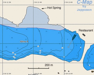
Loutra


![]() 37°26.6′N, 24°25.9′E
37°26.6′N, 24°25.9′E
The harbour of Loutra (Λουτρά) is on the NE side of the island and is somewhat more yacht-friendly than the main ferry harbour. Although the prevailing NE winds blow down into the bay and cause a pronounced swell, the harbour, situated at the extreme W end of the bay, escapes much of the worst. The harbour is defined by a long NE breakwater with an L-shaped extension and, on the SW side, by a short jetty filled with local small craft. It is quite small, and yachts are advised to prepare anchors, lines and fenders before entering in view of the limited space to manoeuvre. Yachts can moor in one of three positions: stern/bows-to the quay of the NE breakwater using their anchors, where there is space for around 12 yachts; alongside the inside of the L-shaped extension, where there is space for two yachts; or alongside the outside of this extension, where there is room for four yachts. The last position experiences some swell with strong NE winds and is very uncomfortable in gales from this direction. The remaining positions afford very good shelter in all winds. There are plentiful water and electricity points along the quays.
An alternative if the harbour is full is the anchorage of Ay Irini, a deep inlet at the SE end of the bay. A yacht can anchor here in 3.0 – 5.0 metres and take a line ashore to rings in the rocks on the N side of the inlet. Shelter here is reasonably good in moderate winds, though a swell comes in with strong NE winds.
In the town are the main hot springs from which Kea derives its alternative name of Thermia. There are several tavernas around the harbour, a couple of good minimarkets in the village and car and scooter rental can be arranged.
Last Visited & Details Checked (and updated here)
Date of member's visit to this Port/Stop & this page's details validated:
- May, 2010 --Istioploos
- September 2011 --Athene of Lymington 16:28, 6 September 2011 (BST)
Anchorages
Fikiadha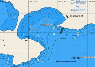
 Greece Kythnos Fikiada h.jpg

 37°24.7′N, 24°23′E
Fikiadha (Φικιάδα) is a beautiful anchorage, and is very well protected from both the meltemi and southerlies. Depending on the prevailing wind, anchor either on the N or S side of the little cove. Be careful, because there is weed at the bottom and sometimes anchors give the appearance of having caught but come undone when strained by a strong gust. Always check the anchor by snorkeling. If the anchorage is full, you can drop your anchor near the NW and take a line to the N shore. There is now a restaurant over the sandbar. Its food is of an indifferent quality.
Last Visited & Details Checked (and updated here)
Date of member's visit to this Port/Stop & this page's details validated:
- May 2010 --Istioploos
 Aerial View of Fikiadha & Kolimpithres |
 The Sandbar in Fikiadha |
 Fikiadha from the E |
Kolimpithres
 Greece Kythnos Kolona h.jpg 37°24.9′N, 24°22′E
Kolimpithres or Kolona is E of the sand bar which separates it from Fikiada is also a very attractive anchorage. It is very well protected from both the meltemi and southerlies. On a small beach on the N side of the cove, there is a hot spring in the shape of a small bathtub where you can relax. Unfortunately, it is very popular with motor cruisers from Athens during the summer weekends. Anchor to the S and take a line to a rock on the N shore. The bottom is weed and not always good holding. Drop the anchor on a sandy patch and always check the anchor by snorkeling. 

Last Visited & Details Checked (and updated here)
Date of member's visit to this Port/Stop & this page's details validated:
- May 2010 --Istioploos
Apokrousis Greece Kythnos Apokrisis h.jpg

37°24.8′N, 24°23.8′E
This cove is just E of Fikiada (sometimes it is referred as Apokrisis or Apokriosis). It is well protected. Be careful, because there is weed at the bottom and sometimes anchors give the appearance of having caught but come undone when strained by a strong gust. Anchor in 4.0 metres and check the anchor by snorkeling. 
Last Visited & Details Checked (and updated here)
Date of member's visit to this Port/Stop & this page's details validated:
- June, 2003 --Istioploos
Ayios Stefanos & Ayios Ioannis Kythnos AyIoannis2.jpg

![]() 37°23.3′N, 24°27.9′E - Chartlet
37°23.3′N, 24°27.9′E - Chartlet
These two bays are on the E coast of the island. They provide good shelter from the meltemi.
Last Visited & Details Checked (and updated here)
Date of member's visit to this Port/Stop & this page's details validated:
- September 2000 --Istioploos
Episkopis
![]() 37°24.1′N, 24°23.6′E - Chartlet
37°24.1′N, 24°23.6′E - Chartlet
Open to the W. Swell enters with the meltemi. Good only in calm weather.
Kanala
![]() 37°20.5′N, 24°26.1′E
37°20.5′N, 24°26.1′E
Open to the SE. Not very good shelter from the meltemi. Good only in calm weather.
Ayios Nikolaos
![]() 37°18.8′N, 24°24.3′E
37°18.8′N, 24°24.3′E
Nice cove. Open to the SE. Not very good shelter from the meltemi. Good only in calm weather.
Last Visited & Details Checked (and updated here)
Date of member's visit to this Port/Stop & this page's details validated:
- 1997 --Istioploos
Marinas & Yacht Clubs
None.
Yacht Services and Repairs
Marine Stores
None.
Yacht Services/Repairs/Yards
None.
Fuel, Water, & Electricity
- Fuel
- fuel can be delivered at Loutra and Merikas. Call +30 6945 316808 or +30 22810 31419
- Water
- is available on the quay at Loutra, there is an extra charge for this
- Electricity
- is available on the quay at Loutra, there is an extra charge for this
Offshore Islands
Tourism and Things to do Ashore
Tourism
Tourism & things to do ashore

- Visit Chora, two miles S of Loutra and the same distance E of Merikas.
- Take a bath in the hot springs of Loutra
- Visit the churches, some of which are quite old
Grocery & Supply Stores
Several small stores in Loutra and Merikas.
Eateries
- Excellent food at the Steki in Chora (tel. +30 22810 31 204). You can call the taxi of Moschoula's (the proprietress) brother Yiannis, at +30 6944 271 609 or +30 22810 31272. He can pick you up from Loutra or where the road ends in Apokrousis where you could go with the dinghy from Fikiadha
- In Loutra there are very good local meat dishes at the Koutsikos, on the road to Chora
- In Loutra there is good sea food at the Araxovoli at the harbor
Internet/WiFi
In internet cafés in Merikas and Loutra.
Laundry
Motorbike & Car Rentals
Can be arranged in Merikas and Loutra.
Transportation
There are ferries, several per day, to Lavrio and in the summer hydrofoils from Zea.
Garbage Disposal
There are bins around the two harbours and in several anchorages.
Routes/Passages To/From
- Passages between Athens Region and Samos - Kusadasi
- Passages between Athens Region and Rhodes - Marmaris
- Cruising the Cyclades Islands
Cruiser's Friends
Contact details of "Cruiser's Friends" that can be contacted for local information or assistance.
Forum Discussions
List links to discussion threads on partnering forums. (see link for requirements)
External Links
References & Publications
See Greece.
Last Visited & Details Checked (and updated here)
See individual ports in this page.
Personal Notes
Personal experiences?
|
|---|
|
Names: --Athene of Lymington 16:28, 6 September 2011 (BST) |
|
|
|---|
| | HOMEPAGE | Wiki Contents | Mediterranean | Aegean Sea | Greece | Kythnos | |
.