Spinaloga
From CruisersWiki
m (Text replace - " <small>[''add 3 tildes (<nowiki>~~~</nowiki>) on the name line'']</small>" to "") |
Istioploos (Talk | contribs) (Added contributors) |
||
| Line 13: | Line 13: | ||
| [http://mapserver.mytopo.com/homepage/index.cfm?lat=35.2846587768488&lon=25.73365080647424&scale=150000&zoom=100&type=0&icon=0&searchscope=dom&CFID=29704&CFTOKEN=79115022&scriptfile=http://mapserver.mytopo.com/homepage/index.cfm&latlontype=DMS Local chartlet] | | [http://mapserver.mytopo.com/homepage/index.cfm?lat=35.2846587768488&lon=25.73365080647424&scale=150000&zoom=100&type=0&icon=0&searchscope=dom&CFID=29704&CFTOKEN=79115022&scriptfile=http://mapserver.mytopo.com/homepage/index.cfm&latlontype=DMS Local chartlet] | ||
|} | |} | ||
| - | + | {{TOCleft}} | |
| - | [[Image:Crete_Spinalonga.jpg|350px|thumb|right|The island of Spinalonga<br/>''Click for larger view'']] | + | [[Image:Crete_Spinalonga.jpg|350px|thumb|right|The island of Spinalonga<br />''Click for larger view'']] |
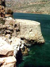
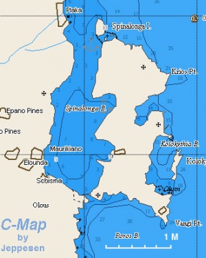
The Spinaloga or Spinalonga (Σπιναλόγκα) lagoon is formed by a long peninsula, almost an island, connected with Crete with a very narrow sandbar, near the very developed region of [http://www.interkriti.org/visits/elouda.html Elounda]. At the western tip of the peninsula there is a small island, the [http://en.wikipedia.org/wiki/Spinalonga Spinalonga Island]. On the Cretan side of the lagoon are high mountains. As described by [http://www.imray.com/record.cfm?i_stock_code=IB0050 Heikell], the Spinalonga lagoon is very calm but experiences fierce gusts from the mountains, although it is somewhat sheltered on the lee side of the Spinalonga Island. The island is surrounded by most imposing [http://en.wikipedia.org/wiki/Venice_Republic Venetian] fortifications. | The Spinaloga or Spinalonga (Σπιναλόγκα) lagoon is formed by a long peninsula, almost an island, connected with Crete with a very narrow sandbar, near the very developed region of [http://www.interkriti.org/visits/elouda.html Elounda]. At the western tip of the peninsula there is a small island, the [http://en.wikipedia.org/wiki/Spinalonga Spinalonga Island]. On the Cretan side of the lagoon are high mountains. As described by [http://www.imray.com/record.cfm?i_stock_code=IB0050 Heikell], the Spinalonga lagoon is very calm but experiences fierce gusts from the mountains, although it is somewhat sheltered on the lee side of the Spinalonga Island. The island is surrounded by most imposing [http://en.wikipedia.org/wiki/Venice_Republic Venetian] fortifications. | ||
| Line 21: | Line 21: | ||
==Charts== | ==Charts== | ||
| - | [[Image:Greece_Crete_Spinalonga_m.jpg|300px|thumb|right|Chart of Spinaloga Region - [http://mapserver.maptech.com/homepage/index.cfm?lat=35.295&lon=25.738333&scale=150000&zoom=100&type=0&icon=0&searchscope=dom&CFID=1509264&CFTOKEN=22608242&scriptfile=http://mapserver.maptech.com/homepage/index.cfm&latlontype=DMS Chartlet]<br/>''Click for larger view'']] | + | [[Image:Greece_Crete_Spinalonga_m.jpg|300px|thumb|right|Chart of Spinaloga Region - [http://mapserver.maptech.com/homepage/index.cfm?lat=35.295&lon=25.738333&scale=150000&zoom=100&type=0&icon=0&searchscope=dom&CFID=1509264&CFTOKEN=22608242&scriptfile=http://mapserver.maptech.com/homepage/index.cfm&latlontype=DMS Chartlet]<br />''Click for larger view'']] |
See [[Crete#Charts|Crete]] | See [[Crete#Charts|Crete]] | ||
| Line 37: | Line 37: | ||
==Check-in facilities== | ==Check-in facilities== | ||
None. | None. | ||
| - | + | <div style="clear: both;"></div> | |
==Offshore Islands and Groups== | ==Offshore Islands and Groups== | ||
====Spinaloga Island==== | ====Spinaloga Island==== | ||
| - | [[image:World_icon.png]] {{Coord|35|17.7|N|25|44.3|E|}}<br/> | + | [[image:World_icon.png]] {{Coord|35|17.7|N|25|44.3|E|}}<br /> |
It is possible to anchor temporarily on the NE side of the island while visiting the island. Anchor as close to the island as the depth allow, the lagoon being very shallow with hardly any depths deeper than 5 m. | It is possible to anchor temporarily on the NE side of the island while visiting the island. Anchor as close to the island as the depth allow, the lagoon being very shallow with hardly any depths deeper than 5 m. | ||
| Line 46: | Line 46: | ||
<center><gallery caption="Spinaloga" widths="300px" heights="170px" perrow="2"> | <center><gallery caption="Spinaloga" widths="300px" heights="170px" perrow="2"> | ||
| - | Image:Spinalonga.jpeg|The anchorage<br/>''Click for larger view'' | + | Image:Spinalonga.jpeg|The anchorage<br />''Click for larger view'' |
| - | Image:Spinalonga2.jpeg|Entrance to old town<br/>''Click for larger view'' | + | Image:Spinalonga2.jpeg|Entrance to old town<br />''Click for larger view'' |
</gallery></center> | </gallery></center> | ||
| Line 55: | Line 55: | ||
==Anchorages== | ==Anchorages== | ||
====Spinaloga Lagoon==== | ====Spinaloga Lagoon==== | ||
| - | [[image:World_icon.png]] {{Coord|35|16.8|N|25|44.4|E|}}<br/> | + | [[image:World_icon.png]] {{Coord|35|16.8|N|25|44.4|E|}}<br /> |
Here a boat is very well protected despite the gusts. There is a good anchorage in 5-7 meters in the bight to the west of Spinalonga peninsula. Anchor in the center of the cove, if possible, to allow for swinging as the wind can come from many directions during the gusts. I have stayed here with some comfort during a force 7 gale (--[[User:Istioploos|Istioploos]]). | Here a boat is very well protected despite the gusts. There is a good anchorage in 5-7 meters in the bight to the west of Spinalonga peninsula. Anchor in the center of the cove, if possible, to allow for swinging as the wind can come from many directions during the gusts. I have stayed here with some comfort during a force 7 gale (--[[User:Istioploos|Istioploos]]). | ||
With fresh northerlies or northwesterlies, conditions are gusty and quite choppy around Spinalonga island itself, but become much less so towards the southern part of the lagoon off Elounda. In addition to the anchorage above, there is also a good anchorage off the beach to the north of Elounda village, with some protection from northerly winds. | With fresh northerlies or northwesterlies, conditions are gusty and quite choppy around Spinalonga island itself, but become much less so towards the southern part of the lagoon off Elounda. In addition to the anchorage above, there is also a good anchorage off the beach to the north of Elounda village, with some protection from northerly winds. | ||
| - | <center><gallery widths="250px" heights="170px" perrow="2"> | + | <center style="clear: both;"><gallery widths="250px" heights="170px" perrow="2"> |
Image:Elounda.jpeg|Elounda fishing harbour<br/>''Click for larger view'' | Image:Elounda.jpeg|Elounda fishing harbour<br/>''Click for larger view'' | ||
Image:Crete_Spinalonga11.jpg|The Spinaloga Lagoon<br/>''Click for larger view'' | Image:Crete_Spinalonga11.jpg|The Spinaloga Lagoon<br/>''Click for larger view'' | ||
| Line 84: | Line 84: | ||
{| class="wikitable" align=right | {| class="wikitable" align=right | ||
|- | |- | ||
| - | |[[Image:Crete_Spinalonga5.jpg|200px]]<br/><small>The Ramparts of the Castle</small> | + | |[[Image:Crete_Spinalonga5.jpg|200px]]<br /><small>The Ramparts of the Castle</small> |
|- | |- | ||
| - | |[[Image:Crete_Spinalonga7.jpg|200px]]<br/><small>The Castle's Gate</small> | + | |[[Image:Crete_Spinalonga7.jpg|200px]]<br /><small>The Castle's Gate</small> |
|} | |} | ||
| Line 147: | Line 147: | ||
| - | <br/> | + | <br /> |
{|id="mp-right" width="100%" cellpadding="2" cellspacing="1" style="vertical-align:top; background:#fff5ee; border:1px solid #fa8072;" | {|id="mp-right" width="100%" cellpadding="2" cellspacing="1" style="vertical-align:top; background:#fff5ee; border:1px solid #fa8072;" | ||
! <h2 id="mp-itn-h2" style="margin:0; background:#ffe4e1; font-size:120%; font-weight:bold; border:1px solid #fa8072; text-align:left; color:#000; padding:0.2em 0.4em;">[[image:SailorSmiley.gif]]Contributors to this page</h2> | ! <h2 id="mp-itn-h2" style="margin:0; background:#ffe4e1; font-size:120%; font-weight:bold; border:1px solid #fa8072; text-align:left; color:#000; padding:0.2em 0.4em;">[[image:SailorSmiley.gif]]Contributors to this page</h2> | ||
|- | |- | ||
|style="color:#000;"|<small> | |style="color:#000;"|<small> | ||
| - | '''Names''': | + | '''Names''': [[User:Istioploos|Istioploos], [[User:Atheneoflymington|Atheneoflymington]] |
</small> | </small> | ||
|} | |} | ||
| - | <br> | + | |
| + | <br /> | ||
{|id="mp-right" width="100%" cellpadding="2" cellspacing="1" style="vertical-align:top; background:#f5faff; border:1px solid #a3b0bf;" | {|id="mp-right" width="100%" cellpadding="2" cellspacing="1" style="vertical-align:top; background:#f5faff; border:1px solid #a3b0bf;" | ||
! <h2 id="mp-itn-h2" style="margin:0; background:#cedff2; font-size:120%; font-weight:bold; border:1px solid #a3b0bf; text-align:left; color:#000; padding:0.2em 0.4em;">Cruising Wiki Navigation</h2> | ! <h2 id="mp-itn-h2" style="margin:0; background:#cedff2; font-size:120%; font-weight:bold; border:1px solid #a3b0bf; text-align:left; color:#000; padding:0.2em 0.4em;">Cruising Wiki Navigation</h2> | ||
| Line 163: | Line 164: | ||
| - | [[Category: | + | [[Category:Anchorages - Greece]] [[Category:Ports - Crete]] |
| - | + | ||
| - | + | ||
Revision as of 16:59, 10 December 2011
Spinaloga
| | |
| | 35°17.7′N, 25°44.3′E |
|---|---|
| | Photo gallery |
| | Local chartlet |
The Spinaloga or Spinalonga (Σπιναλόγκα) lagoon is formed by a long peninsula, almost an island, connected with Crete with a very narrow sandbar, near the very developed region of Elounda. At the western tip of the peninsula there is a small island, the Spinalonga Island. On the Cretan side of the lagoon are high mountains. As described by Heikell, the Spinalonga lagoon is very calm but experiences fierce gusts from the mountains, although it is somewhat sheltered on the lee side of the Spinalonga Island. The island is surrounded by most imposing Venetian fortifications.
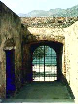
The island was used as Greece's main leper colony as late as 1957. It is now a very popular tourist attraction, the tourists being brought by an endless string of day-trip boats with their loud speakers blaring the spiel in all languages, but predominately in German. They come and go disgorging the tourists at a small landing and taking them back. This seems to go on relentlessly all day until the late afternoon. Surprising enough, the island is not crowded, and walking on it, one gets a very strong sense of isolation. It is very definitely a haunted place. There are on-going efforts to restore the old buildings and fortifications. There are extensive and large Venetian fortifications almost enclosing the island, Venetian houses, a Venetian castle at the island's peak, and many small Venetian and more recent Ottoman houses. In addition, there are a few large 1930 fascist-style institutional buildings, mostly used as hospitals. The lepers, who at any given time did not exceed 200 to 300 people, lived mostly in the old houses, and there are over 1,500 buried here. They lived all by themselves with minimum contact with the outside world until the 30s when the state built "modern" hospital buildings and other facilities for them. These are the most run down and ugly structures in the island. Other than these, the place has an amazing beauty and attraction as the lagoon is really very beautiful and so are the little houses and churches. But one cannot help but feel the weight of all the miserable souls that perished here after years of neglect and isolation.
Charts
See Crete
Radio Nets
See also Crete
- Olympia Radio - VHF no signal
Local Weather
See Aegean Sea.
Approaching Spinaloga is straightforward but Warning: be aware that very strong gusts can suddenly develop.
Check-in facilities
None.
Offshore Islands and Groups
Spinaloga Island
![]() 35°17.7′N, 25°44.3′E
35°17.7′N, 25°44.3′E
It is possible to anchor temporarily on the NE side of the island while visiting the island. Anchor as close to the island as the depth allow, the lagoon being very shallow with hardly any depths deeper than 5 m.
Caution: Before going ashore make sure that the anchor has settled and it is holding.
Marinas & Yacht Clubs
None.
Anchorages
Spinaloga Lagoon
![]() 35°16.8′N, 25°44.4′E
35°16.8′N, 25°44.4′E
Here a boat is very well protected despite the gusts. There is a good anchorage in 5-7 meters in the bight to the west of Spinalonga peninsula. Anchor in the center of the cove, if possible, to allow for swinging as the wind can come from many directions during the gusts. I have stayed here with some comfort during a force 7 gale (--Istioploos).
With fresh northerlies or northwesterlies, conditions are gusty and quite choppy around Spinalonga island itself, but become much less so towards the southern part of the lagoon off Elounda. In addition to the anchorage above, there is also a good anchorage off the beach to the north of Elounda village, with some protection from northerly winds.
Yacht Repairs and Services
Marine Stores
None.
Repairs/Yards
None.
Fuel, Water, & Electricity
- Fuel
- N/A (Not Available)
- Water
- N/A
- Electricity
- N/A
Tourism and Things to do Ashore
Tourism
 The Ramparts of the Castle |
 The Castle's Gate |
The main attraction is, of course, the island of Spinalonga.
Grocery & Supply Stores
N/A.
Eateries
N/A.
Internet/WiFi
N/A.
Laundry
N/A.
Motorbike & Car Rentals
N/A.
Garbage Disposal
N/A.
Transportation
Only day-trip boats.
Routes/Passages To/From
See Crete.
Cruiser's Friends
Contact details of "Cruiser's Friends" that can be contacted for local information or assistance.
Forum Discussions
List links to discussion threads on partnering forums. (see link for requirements)
External Links
- Spinalonga Island (Wikipedia)
References & Publications
See Greece.
Last Visited & Details Checked (and updated here)
Date of member's visit to this Port/Stop & this page's details validated:
- September 1997 --Istioploos

- July 2009 --Atheneoflymington 11:25, 11 July 2009 (UTC)
Personal Notes
Personal experiences?
|
|---|
|
Names: [[User:Istioploos|Istioploos], Atheneoflymington |
| |
|---|
| | HOMEPAGE | Wiki Contents | Mediterranean | Aegean Sea | Greece | Crete | Spinaloga | |


