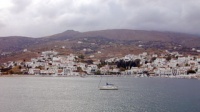
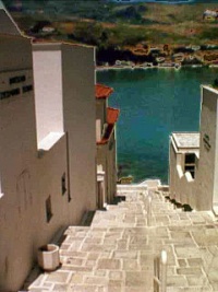
Andros-Greece
From CruisersWiki
Andros, Greece
GPS: 37°53′N, 24°44′E
Background
Andros (Άνδρος), a member of the Cyclades. It is 380,041 km2 and has about 10,009 inhabitants. The highest peak of Andros is 944 m (3097 ft). Andros is not a very touristic island but it is the home of several very rich shipowner families like the fabulously wealthy Goulandris; as a result it is very well kept without the usual tourist related hassles.
The island was named after the Cretan general Andros, the grandson of Apollo. It has been inhabited since pre-historic times by Karians, Phoenicians, Egyptians, Cretans, Pelasgians, and Ionian Greeks. During the 7th century BC Andros was very prosperous. In Classical times Andros was a reluctant member of the Delian Leaque headed by Athens. During the 13th century AD it was taken from the Byzantines by the Frankish crusaders and then by the Ottomans in 1556 to be followed by the Russians in 1774. After the 1821 war of independence Andros became part of Modern Greece.
Charts
- BA 2682 Kólpos Patalion to Nísos Nísiros
- BA 1038 Stenó Sífnou to Stenó Kafiréa
- Imray-Tetra G3 Aegean Sea (South)
- Imray-Tetra G31 Northern Cyclades
- NIMA 54355 Nisos Andros & Dhiekplous Kafireos
- Greek 42 Andros to Chalki Island
- Greek 421 Karystos to Naxos
Radio Nets
Also see Cruiser's Nets
- Coast Guard - VHF channel 12 Tel. +30 2820 22 572
- Olympia Radio - VHF channel 04
In general the west side of the island experiences strong gusts when the meltemi blows. For particulars see individual ports or anchorages.
Ports and Popular Stops
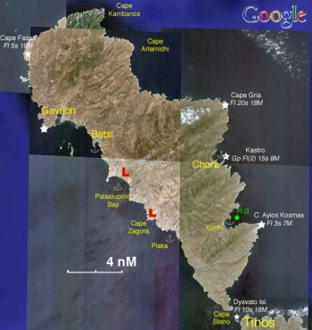
There are several anchorages in Andros. The main harbor on the more protected west side of the island, Gavrio is very busy with ferry boats. Most cruisers prefer the quieter, nearby Batsi.
Gavrio
| GPS: 37°53′N, 24°44′E
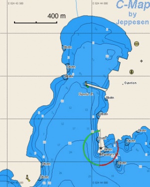
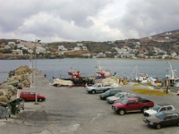
Gavrio (Γαύριο) provides the best shelter in the island. You can either anchor off-shore or go stern-to at the quay. The bottom is mud and provides good holding. Caution: There are several reefs in the approach to Gavrio. In particular there is Vouvi with dangerous shoals at the sourh-east entrance, the rock Rosa, and shoal waters near the islets Akamatis and Plati. Last Visited & Details Checked (and updated here)Date of member's visit to this Port/Stop & this page's details validated:
|
Batsi
| GPS: 37°51.5′N, 24°47′E
Batsi (Μπατσί) is just 2 3/4 nM south-east of Gavrio and provides good shelter, although it can be gusty, from the meltemi but it is exposed to the south. You can either anchor off-shore or go stern-to at the small quay. The bottom is sand and provides good holding. This is a pleasant and quiet anchorage (if you are off-shore) and yet there are enough stores and restaurants ashore. There is fuel available from a station but it is uphill and out of town, not an easy walk carrying jerry cans. You can rent cars and motorbikes. Last Visited & Details Checked (and updated here)Date of member's visit to this Port/Stop & this page's details validated:
|
Kastro
GPS: 37°50.6′N, 24°56.4′E - Chartlet
Kastro (Κάστρο) is the capital of Andros also known as Andros or Chora or Hora.
Danger: The is not protected from the meltemi and it can be dangerous. There is a dangerous reef directly at the approach into the harbor.
Anchorages
Korthi
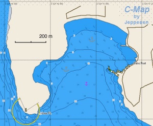
GPS: 37°46.5′N, 24°57.9′E - Chartlet
Korthi (Κορθί) is a very lovely cove.
Warning: It is exposed to the east and it is not protected from the meltemi and it can be dangerous when it blows.
Palaioupolis Bay
GPS: 37°49′N, 24°49′E - Chartlet
This is a lovely anchorage about 3 nMi south-east of Batsi. There is reasonable protection from the meltemi but it is very exposed to the south.
Anchor off-shore. The bottom is sand.
There are some underwater foundations of the ancient harbor and some ruins ashore.
Plaka Bay
GPS: 37°45.8′N, 24°53.1′E - Chartlet
This is a small bay south of Cape Zagora.
Offshore Islands
Yiaros
GPS: 37°35.5′N, 24°42.7′E - Chartlet
Yiaros is a barren uninhabited island mid-way between Kea and Tinos and about 8 nM south-west of Andros. There are no anchorages but with sheltered weather one can anchor in an exposed little cove on its south side of the island for lunch or a swim. There are strong gusts here with the meltemi.
The island was used as a place of exile for political prisoners as recently as during theJunta of the Colonels (1967-72).
Routes/Passages To/From
Popular passages/routes, timing, etc.
Tourism & things to do ashore
Chora
Chora (Χώρα) is the capital of Andros also known as Andros or Hora. It is a very picturesque town with traditional Cycladic architecture.
In town, of interest are the Archaeological Museum which houses many finds from Palaiopolis and Zagora. There is also a small but very good Museum of Modern Art which houses a collection of the local sculptor M. Tombros as well as works of the most important contemporary Greek artists. They also have regular exhibits of non-Greek modern artists. The museum is housed in a very pleasant building which harmonizes with the Cycladic architecture.
In modern times Andros has been the home island of many wealthy shipowners, in particular the various members of the Goulandris family. The Maritime Museum of Andros shows some of this tradition.
Palaiopolis
In addition to the excavation site and the underwater jetty there is a local exhibit of the Archaeological Collection of Palaiopolis.
Zagora
Here is the site of the Geometric settlement at Zagora.
Gavrion
A prominent feature of Gavrion is the Tower at Aghios Petros. It is dated from the Hellenistic period (4th-3rd centuries BC) and it is worth a visit.
Fuel, Water, & Electricity
- Fuel - There is fuel available in Batsi from a station but it is uphill and out of town, not an easy walk carrying jerry cans.
- Water - ?
- Electricity - Ν/Α
Laundry
Grocery Stores
Eateries
- In [#Batsi|Batsi]] Adonis serves some very good mezedes (tasty morsels)
- Several restaurants in both Gavrio and Batsi
Motorbike & Car Rentals
Available in both Gavrio and Batsi
Marine Stores & Facilities
Submit addresses and contact details of marine related businesses that are of interest to cruisers.
Repairs
Transportation
There are daily, and in the summer several per day ferries to Rafina.
References & Publications
See Greece.
Cruiser's Friends
Contact details of "Cruiser's Friends" that can be contacted for local information or assistance.
Forum Discussions
List links to discussion threads on the Cruiser Log Forum
External Links
- Andros (Wikipedia)
Personal Notes
Personal experiences?
Last Visited & Details Checked (and updated here)
See individual ports in this page.
| |
|---|
| | HOMEPAGE | Wiki Contents | Mediterranean | Aegean Sea | Greece | Andros | |
.
