Belep
From CruisersWiki
m (bot: Article with tables categorisation) |
m (bot: Article with infobox table categorisation) |
||
| Line 16: | Line 16: | ||
|- | |- | ||
| colspan="2" style="text-align:center; font-size: smaller;" | [[Image:Wala.jpg|350px]]'''Wala, the main village in the Belep islands''' - ''Click for larger view'' | | colspan="2" style="text-align:center; font-size: smaller;" | [[Image:Wala.jpg|350px]]'''Wala, the main village in the Belep islands''' - ''Click for larger view'' | ||
| - | |}{{TOCleft}} | + | |}[[Category:Articles with infobox table]]{{TOCleft}} |
The [http://en.wikipedia.org/wiki/Belep Belep Islands] are the northern most inhabited islands in New Caledonia. They lie approximately 40 nm from Poum, the nearest centre on Grande Terre. There are very limited opportunities to anchor between Poum and Wala, so it is best to assume that the trip needs to be done in a single day run. The direct track from Poum is free of dangers and nearby hazards are charted. Be cautious of relying to closely on electronic charts in this area - there appear to be some discrepancies. | The [http://en.wikipedia.org/wiki/Belep Belep Islands] are the northern most inhabited islands in New Caledonia. They lie approximately 40 nm from Poum, the nearest centre on Grande Terre. There are very limited opportunities to anchor between Poum and Wala, so it is best to assume that the trip needs to be done in a single day run. The direct track from Poum is free of dangers and nearby hazards are charted. Be cautious of relying to closely on electronic charts in this area - there appear to be some discrepancies. | ||
Revision as of 12:42, 6 March 2016
Belep, New Caledonia
| | |
| | 19°40.7′S, 163°38.8′E |
|---|---|
| | Photo gallery |
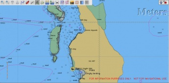
| | Local chartlet |
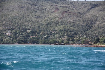
 Wala, the main village in the Belep islands - Click for larger view Wala, the main village in the Belep islands - Click for larger view
| |
The Belep Islands are the northern most inhabited islands in New Caledonia. They lie approximately 40 nm from Poum, the nearest centre on Grande Terre. There are very limited opportunities to anchor between Poum and Wala, so it is best to assume that the trip needs to be done in a single day run. The direct track from Poum is free of dangers and nearby hazards are charted. Be cautious of relying to closely on electronic charts in this area - there appear to be some discrepancies.
It is recommended that on arrival in the Belep Islands you observe the Kanak tradition of approaching the Chief, presenting a gift and requesting permission to visit the islands. The local Maire (council chambers) can arrange this. The Maire is close to the OPT building and this is obvious from the telecommunications tower nearby. The Grande Chef is very welcoming. It would be useful if you could discuss football in French!
There are two main islands:
- Ile Art - with the main town of Wala
- Ile Pott
Note, in visiting Belep, it is almost certain that you will have to beat back to Grande Terre against the SE Trade Winds.
Charts
Submit the chart details that are required for safe navigation.
- Chart Source
- Chart Number
Radio Nets
Also see World Cruiser's Nets.
Weather
Local weather conditions?
Sources for Weather forecasts
Local forecasts are, of course, in French, but non-French speakers should find them relatively easy to understand. A very useful vocabulary can be found at How to Understand French Weather Forecasts for Sailors.
The main source of weather information for the area around New Caledonia is Meteo France Nouvelle-Calédonie. The marine section provides a 6 day forecast for the whole region, with details for each of the passes through the barrier reef.
Nouméa radio broadcasts the weather report in French on VHF 16, everyday at 6:30, 9:30, 15:15, 18:30.
There is a set of repeater channels allowing receipt of weather info anywhere in the country:
- Nouméa area: VHF 26
- Southern portion of the Grande Terre: VHF 28
- Isle of Pines and the southern lagoon: VHF 25
- Grande Terre North West coast: VHF 25
- Northern portion of Grande Terre: VHF 24
- Ouvea: VHF 23
- Lifou: VHF 26
- Maré: VHF 87
Caution: Ile Art appears to be a little (~0.3nm) east of its charted position on C-map charts. All dangers appear to be marked, but their position may not be exactly correct.
Check-in facilities (Customs and Immigration)
Check-in MUST be done at Noumea.
Berthing Options
Ports
- Wala is the main town. There is a small enclosed harbour, but this is not suitable for anything larger than the local fishing boats. It is useful for landing a dinghy. Anchorage can be found in 5 - 6 metres in the middle of the bay. Look for the conspicuous church as a landmark. Baie de Wala may not be very sheltered in strong SEly winds.
Marinas & Yacht Clubs
- None
Anchorages
- Bonne Aiguade is a bay approximately 2 1/2 miles north of Wala. This is a much more sheltered anchorage in strong SEly winds.
Offshore Islands
List Islands
Yacht Services and Repairs
Also see each Port.
Marine Stores
None.
Repairs/Yards
None.
Fuel, Water, & Electricity
- Fuel
- Give details on fuel
- Water
- Water may be available at Wala
- Electricity
- Give details on electricity
Things to do Ashore
Tourism
List places of interest, tours, etc.
Grocery & Supply Stores
- There is a local bakery, but it is best to assume that you need to rely on your own stores for all food.
Eateries
Internet/WiFi
Available?
Laundry
- None
Motorbike & Car Rentals
None.
Garbage Disposal
?
Transportation
- There is an airstrip and regular boats from the mainland
Routes/Passages To/From
Popular passages/routes, timing, etc.
Cruiser's Friends
Contact details of "Cruiser's Friends" that can be contacted for local information or assistance.
Forum Discussions
List links to discussion threads on partnering forums. (see link for requirements)
External Links
References & Publications
Publications, Guides, etc.
Personal Notes
Personal experiences?
Last Visited & Details Checked (and updated here)
Date of member's visit to this Port/Stop & this page's details validated:
- July 2010 - Pedro
| This page has an outline in place but needs completing. Please contribute if you can to help it grow further. Click on Comments to suggest further content or alternatively, if you feel confident to edit this page, click on the edit tab at the top and enter your changes directly. |
|
|---|
|
Names: Lighthouse, Pedro |
| |
|---|
| | HOMEPAGE | Wiki Contents | South Pacific | New Caledonia | Belep | |
