Bodrum
From CruisersWiki
Bodrum (Port of entry)
| | Coords: 37°01.5′N, 27°25.7′E Chartlet: Chartlet Gallery: Photos |
Background
Bodrum the ancient Halicarnassus is a bustling harbor town. The old harbor is full of gulets.
Charts
- BA
- 1055 Rhodes Channel and Gökova Körfezi
- Imray-Tetra
- G35 Dodecanese and Coast of Turkey
- NIMA
- 54400 Samos to Rodhos
- Turkey
- 2248 Gündoğan Limanı - Kadıkalesi
- 311 Bodrum Boğazı - Marmaris
- 3110 Bodrum Boğazı
- 3111 A) Bodrum Limanı
- Greek
- 451 Leros to Rhodos
Radio Nets
Also see Cruiser's Nets
Submit details of local radio Nets.
Danger: Approaching Bodrum from the W stay clear of the Dikilitas Reef about 1 nM from the harbor.
Check-in facilities
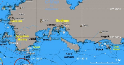
Bodrum is one of Turkey's major yachting regions. As a result there here 3 marinas (Bodrum Marina in Bodrum, Yalikavak Marina, and Turgutreis Marina about 15 nM NW), a boatyard (Icmeler Yat), and several anchorages.
The old Bodrum Harbor caters to commercial gulets and does not welcome yacht.
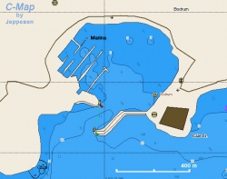
Chart of the Old Harbor and Marina -Chartlet |
Marinas & Yacht Clubs
- Bodrum Marina
- Yalikavak Marina
- Turgutreis Marina
- There is a yachting club based in the marina in Bodrum. They hold frequent races.
Anchorages
Gümüslük
| GPS: 37°03.3′N, 27°14′E
An idyllic although sometimes very busy anchorage on the north west side of the Bodrum peninsular between Turgutreis and Yalikavak. Gumusluk is an ancient harbour, known during former times as Myndos, and some traces of the former settlement remain - especially the half-submerged remains of the ancient breakwaters at the entrance to the harbour. The bay should be entered close to the island on the east side in order to avoid the sunken remains of the mole on the west (which are usually buoyed anyway). Once inside, anchor wherever you can, if necessary taking a line ashore or dropping a kedge anchor to avoid swinging. Depths range from 15-16 meters in the centre to 5-10 meters at the head and sides of the bay. Holding is good once through the weed. Alternatively, it may be possible to anchor moor back to the wooden jetty in front of the village (although the overnight charge, currently YTL30, is kept deliberately high in order to deter private yachts). The anchorage is usually very crowded with private yachts and gulets bringing diners to the restaurants lining the bay and care is usually needed when placing your anchor to avoid frayed tempers. Dining ashore is good - especially fish - but expensive. Date of visit: July 2009 --Atheneoflymington 12:05, 11 July 2009 (UTC) |
Aspat Bay
| GPS: 36°58.4′N, 27°18.2′E - Chartlet
Aspat Bay or Aspat Koyü is a pleasant place to anchor. There are several restaurants ashore. During the day there are a lot of boats from Bodrum In the evening these boats leave but the loud music from the shore establishments start. Anchor in 7 m. Reasonable holding. |
Offshore Islands
Orak Adasi
Routes/Passages To/From
Popular passages/routes, timing, etc.
Tourism & things to do ashore
The town of Bodrum is full of shops and the usual tourist In the old Knights of St. Joan Castle is housed the Underwater Museum with exhibits from the excavations from Serçe Liman, Ulu Burum, etc. Do not miss it.
Fuel, Water, & Electricity
At the Bodrum Marina.
Laundry
At the Bodrum Marina.
Grocery Stores
There numerous food stores in town.
Eateries
- There numerous restaurants in old town
- There is a very good and fancy restaurant in the Bodrum Marina
- Right across from the Bodrum Marina is a "marble palace" Chinese restaurant
Motorbike & Car Rentals
In town.
Marine stores
- At the Bodrum Marina
- At Icmeler Yat (5 km from the town)
Repairs
Major repairs at Icmeler Yat.
Transportation
There are frequent ferries to Kos.
References & Publications
See Turkey.
Cruiser's Friends
Contact details of "Cruiser's Friends" that can be contacted for local information or assistance.
Forum Discussions
List links to discussion threads on the Cruiser Log Forum
External Links
- Bodrum (Wikipedia)
Personal Notes
Personal experiences?
Last Visited & Details Checked (and updated here)
Date of member's visit to this Port/Stop & this page's details validated:
- August 2004 --Istioploos 11:27, 7 June 2008 (MDT)
| |
|---|
| | HOMEPAGE | Wiki Contents | Mediterranean | Aegean Sea | Turkey | Bodrum | |
.


