Bodrum
From CruisersWiki
Revision as of 14:45, 12 January 2010 by Atheneoflymington (Talk | contribs)
Contents |
Bodrum (Port of entry)
| | |
| | 37°01.5′N, 27°25.7′E |
|---|---|
| | Photo gallery |
| | Local chartlet |
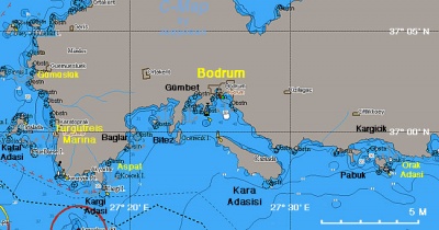
Bodrum the ancient Halicarnassus is a bustling harbor town. The old harbor is full of gulets.
Charts
- BA
- 1055 Rhodes Channel and Gökova Körfezi
- Imray-Tetra
- G35 Dodecanese and Coast of Turkey
- NIMA
- 54400 Samos to Rodhos
- Turkey
- 2248 Gündoğan Limanı - Kadıkalesi
- 311 Bodrum Boğazı - Marmaris
- 3110 Bodrum Boğazı
- 3111 A) Bodrum Limanı
- Greek
- 451 Leros to Rhodos
Radio Nets
Also see Cruiser's Nets
Submit details of local radio Nets.
Local Weather
See Aegean Sea.
Danger: Approaching Bodrum from the W stay clear of the Dikilitas Reef about 1 nM from the harbor.
Check-in facilities
Bodrum is one of Turkey's major yachting regions. As a result there here 4 marinas (Bodrum Marina in Bodrum, Yalikavak Marina, and Turgutreis Marina about 15 nM NW), a boatyard (Icmeler Yat, Port Atami Marina), and several anchorages.
The old Bodrum Harbor caters to commercial gulets and does not welcome yacht.
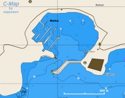
Chart of the Old Harbor and Marina -Chartlet |
==Offshore Islands and Groups==
|
====Orak Adasi====
|
==Marinas & Yacht Clubs==
|
* There is a yachting club based in the marina in Bodrum. They hold frequent races.
|
==Anchorages==
|
====Gümüslük====
|
====Aspat Bay====
|
==Yacht Repairs and Services==
|
====Marine Stores====
|
====Repairs/Yards====
|
====Fuel, Water, & Electricity====
|
; Fuel
|
; Water
|
; Electricity
|
==Tourism and Things to do Ashore==
|
===Tourism===
|
The old-town of Bodrum is full of shops and the usual tourist.
|
===Grocery & Supply Stores===
|
There numerous food stores in town.
|
===Eateries===
|
* There numerous restaurants in old town
|
===Laundry===
|
===Internet/WiFi===
|
===Motorbike & Car Rentals===
|
In town.
|
===Garbage Disposal===
|
===Transportation===
|
* Milas Airport, 23 km. from Bodrum
|
==Routes/Passages To/From==
|
==Cruiser's Friends==
|
Contact details of "Cruiser's Friends" that can be contacted for local information or assistance.
|
==Forum Discussions==
|
List links to discussion threads on the Cruiser Log Forum
|
*
|
*
|
*
|
==External Links==
|
*
|
*
|
==References & Publications==
|
==Last Visited & Details Checked (and updated here)==
|
''Date of member's visit to this Port/Stop & this page's details validated'':
|

